Upper level jet streak and left exit region
A "Rapid Cyclogenesis" is a rapidly deepening storm which can be enlightened from different points of view. In this chapter, the relationship between the upper level jet and its left exit region with "Rapid Cyclogenesis" is studied. All numerical parameter fields are computed from NWP analysis fields.
There is a very distinct connection of "Rapid Cyclogenesis" cases with the corresponding jet streak at, e.g., 300 hPa. This connection shall be be considered from two points of view:
- There are two areas within a jet streak were Wave development is likely: the right entrance region, where developments are usually rather slow, and the left exit region where developments are often extremely rapid. Reasons for the possible developments in these two areas are cross circulation cells with PVA at high levels and frontogenetic effects in lower and middle levels. PVA at higher levels (an increase of PVA with height) contributes to upward motion and is associated with convergence at middle levels and divergence at higher levels. (compare Conceptual Models: Front Intensification by Jet Crossing ).
- If "Rapid Cyclogenesis" has taken place, it can only be in the left exit region. Either a pre-existing surface minimum (Wave) is already located there or moves from the anticyclonic to the cyclonic side of the jet into the relevant region. Such a process can be seen several times during the storms of Christmas 1999.
Lothar and Lothar successor
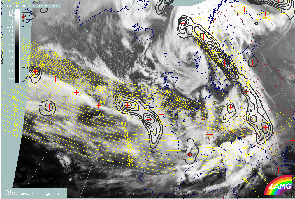
The loop below shows isotachs and PVA at 300 hPa. The combinations of these parameters allows a judgement of the "strength" of the exit region, especially the left exit region, and the relationship between typical cloud configurations and the exit region.
|
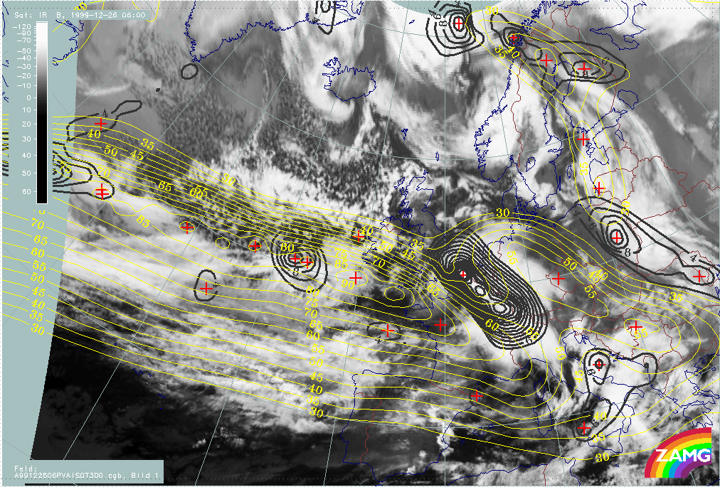
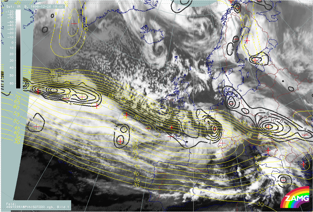
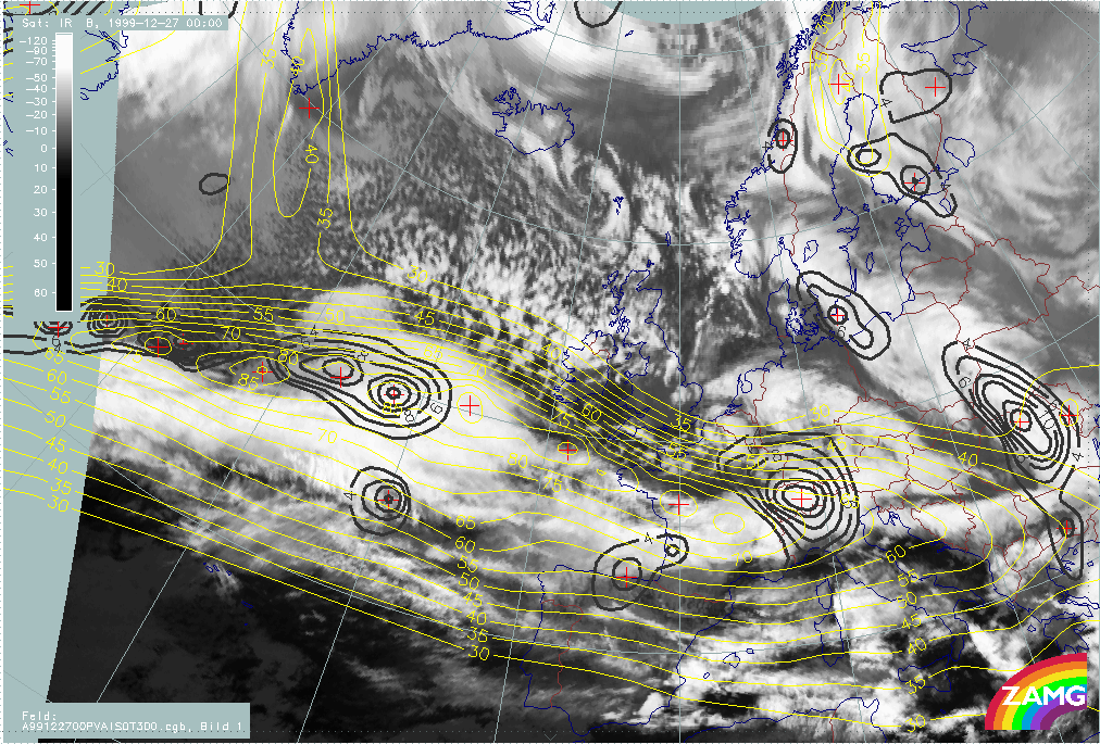
25 December 1999/06.00 UTC - Meteosat IR image; yellow: isotachs 300 hPa, black: positive vorticity advection (PVA) 300 hPa; 25/06.00 - 26/12.00 UTC 6-hourly image loop
|
|
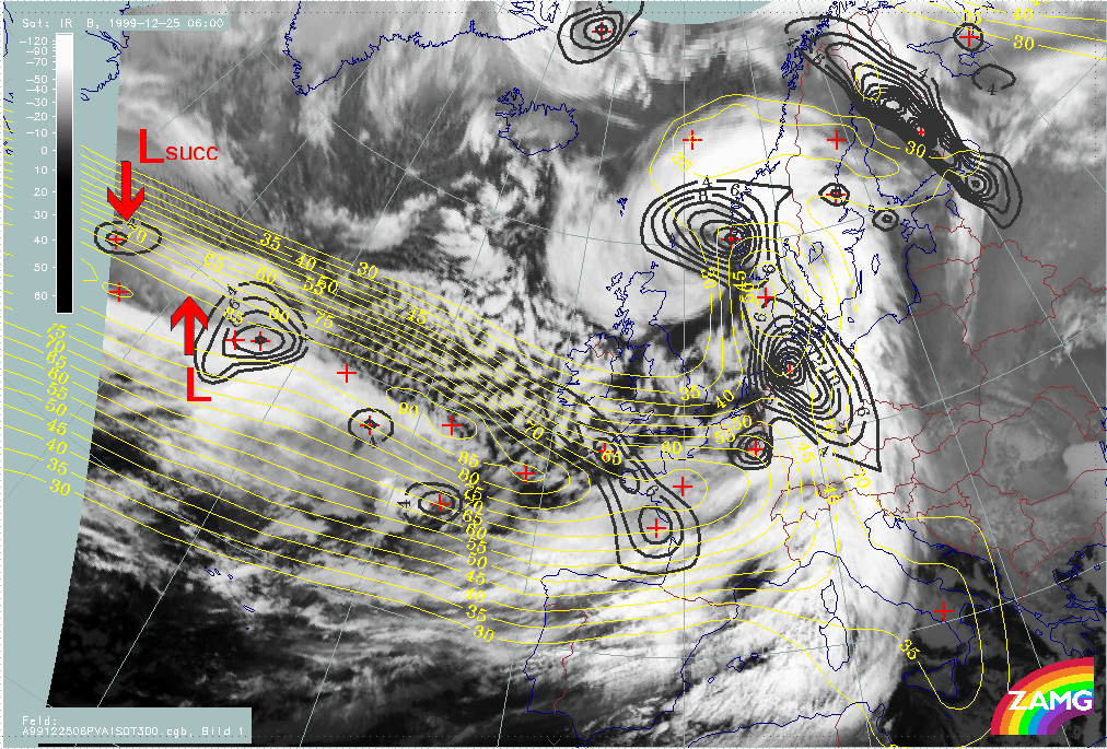
- At the start of this phase (25/06.00 UTC) there is a distinct PVA maximum associated with the "low" cloud head area but this PVA maximum is located within the jet axis. As the jet streak is rather elongated with several maxima, the location of a true exit region is not so clear.
- From 25/12.00 UTC the PVA maximum is clearly associated with a left exit region; both are close to the cloud head area: before rapid development, to the low cloud head area and, after rapid development, to the bright (high) cloud head area.
- Between 25/18.00 UTC and 26/00.00 UTC there is a dramatic intensification of the PVA maximum; this is immediately before the phase of rapid development.
- Consequently, there is a very distinct and clear relationship between "Rapid Cyclogenesis" and a maximum of PVA in the left exit region of a jet streak.
- Similar conclusions can be drawn for Lothar successor: From 26/00.00 UTC, a PVA maximum centred on the jet core is superimposed on the low cloud head; only 12 hours later does a clearer relationship appear between cloud head, PVA maximum and left exit region.
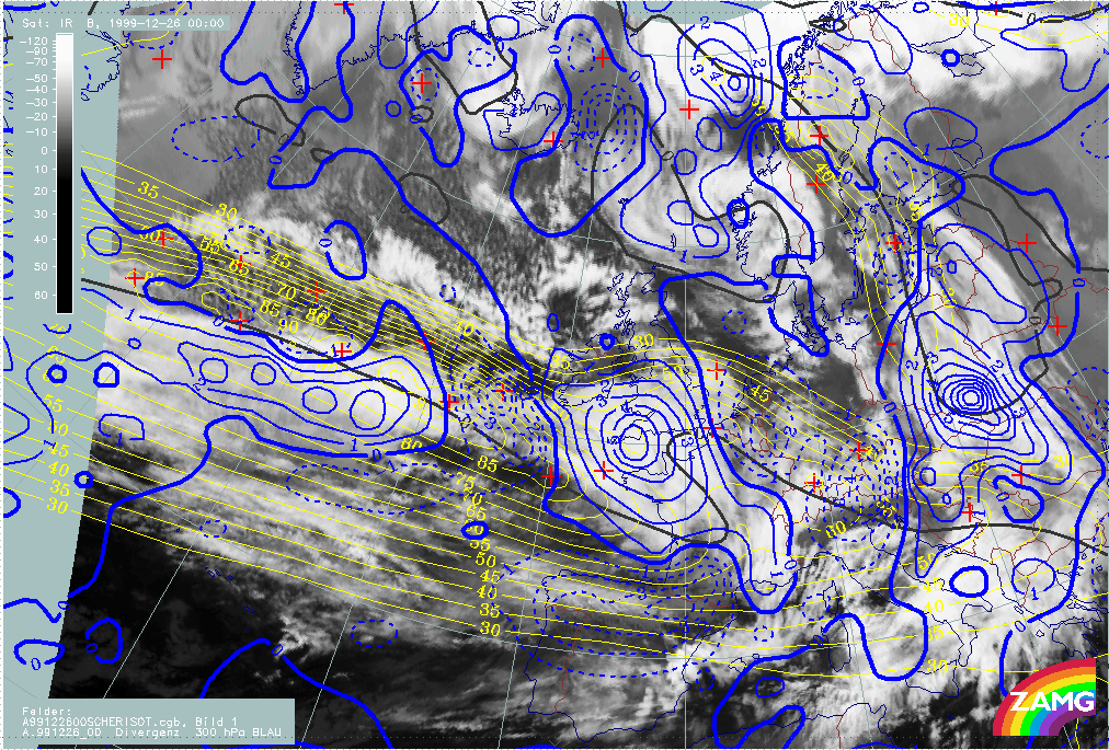
For 26/00.00 UTC the cross circulation cell in the exit region of the jet seems to be very well developed. This can be shown by studying divergence fields at 700 and 500 hPa. As shown below there is an extended area of convergence at 700 hPa in the left exit region of the jet streak which corresponds to the Rapid Cyclogenesis cloud head. In the same area there is divergence at 300 hPa. These are ideal conditions for development.
For Lothar successor there is no such relationship at this stage.
|
26 December 1999/00.00 UTC - Meteosat IR image; yellow: isotachs 300 hPa, black: shear vorticity 300 hPa, red dashed: divergence 700 hPa, red solid: convergence 700 hPa
|
26 December 1999/00.00 UTC - Meteosat IR image; yellow: isotachs 300 hPa, black: shear vorticity 300 hPa, blue dashed: divergence 300 hPa, blue solid: convergence 300 hPa
|

|
|
Martin
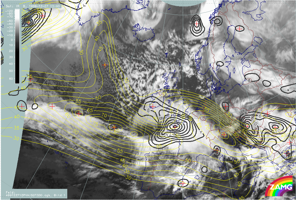
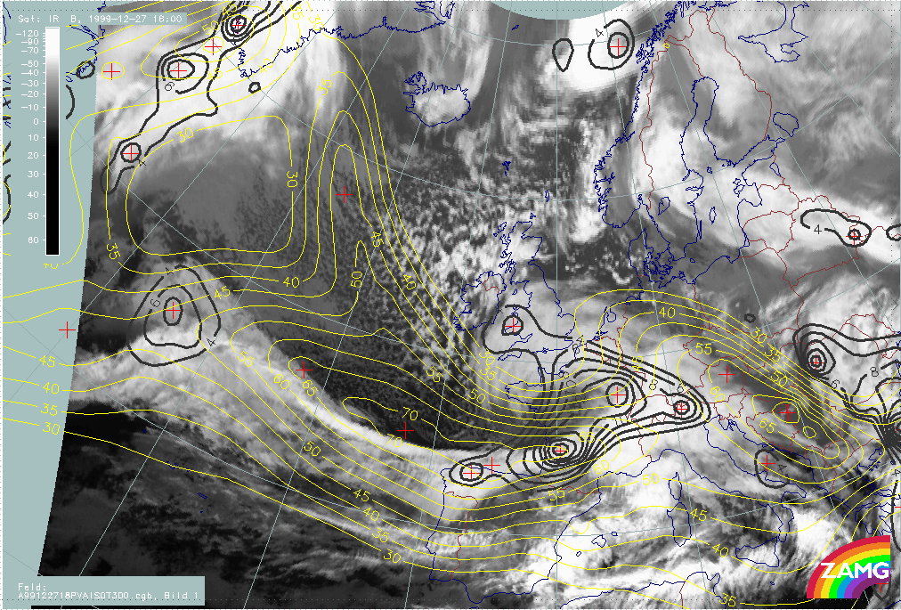
The loop below shows the isotachs and PVA at 300 hPa. The combination of these parameters allows one to judge the strength of the exit regions, especially the left exit region, and the relationship between typical cloud configurations and the exit region.
|
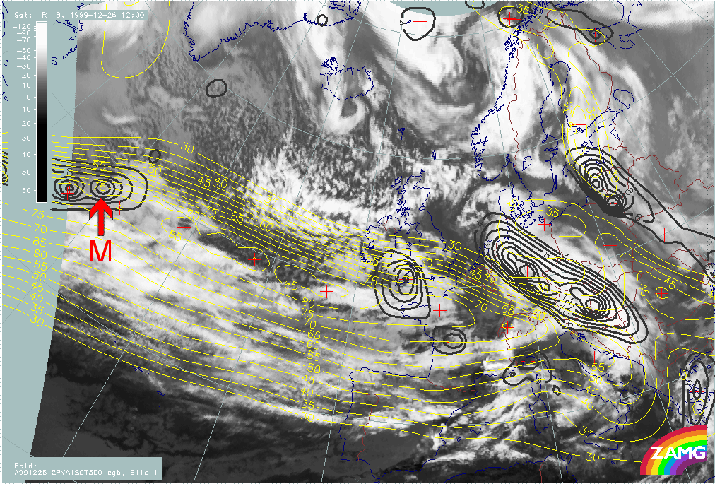
26 December 1999/12.00 UTC - Meteosat IR image; yellow: isotachs 300 hPa, black: positive vorticity advection (PVA) 300 hPa; 26/12.00 - 27/18.00 UTC 6-hourly image loop
|
|
The following remarks can be summarised:
- An intensive PVA maximum at 300 hPa is associated with the low cloud head area during this phase but the relationship with an exit region is, initially, not clear.
- Between 26/18.00 UTC and 27/00.00 UTC a small scale jet streak maximum within the rather elongated jet streak intensifies to the rear of the cloud head; a new PVA maximum develops in the left exit region and becomes associated with the low cloud head feature.
- This development continues and becomes very distinct at 27/06.00 UTC, when a remarkable intensification of the PVA maximum has taken place. This is the phase where rapid system development starts. The PVA maximum is associated with the left exit region of the intensified jet streak as well as the bright cloud head area.
- For a while, Lothar successor also showed this relationship between PVA max and the left exit region of a jet streak; but the relationship tended to disappear in time.
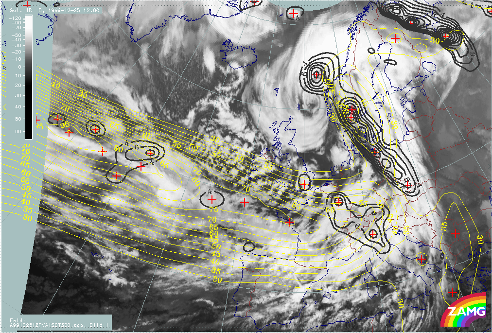
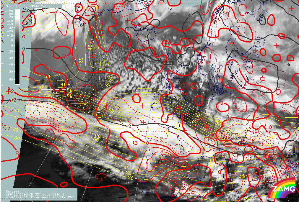
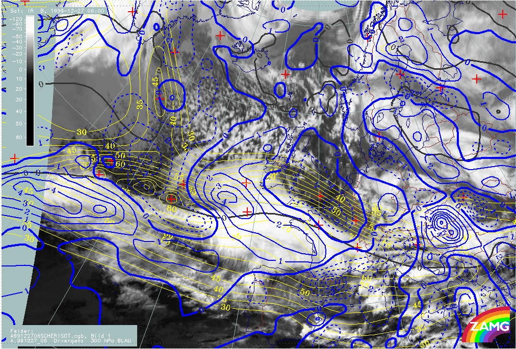
At 27/06.00 UTC, a point in time where the cloud structures of "Rapid Cyclogenesis" are already very distinct, the cross circulation cell in the exit region of the jet seems to be very well developed. This can be seen in divergence fields at 700 and 500 hPa. As shown below, there is an extended area of convergence at 700 hPa in the left exit region of the jet streak, which corresponds to the cloud head. In the same area, there is divergence at 300 hPa. When comparing with Lothar, the vertical distribution of convergence and divergence in the left exit region reflects the classical ideas for both storms, but the situation in the right exit region is much more ideal for Lothar.
|
27 December 1999/06.00 - Meteosat IR image; yellow: isotachs 300 hPa, black: shear vorticity 300 hPa, red dashed: divergence 700 hPa, red solid: convergence 700 hPa
|
27 December 1999/06.00 - Meteosat IR image; yellow: isotachs 300 hPa, black: shear vorticity 300 hPa, blue dashed: divergence 300 hPa, blue solid: convergence 300 hPa
|
|
|