Table of Contents
- I. Introduction
- II. Overview
- Summary of typical cloud features
- Lothar and Lothar successor
- Martin
- III. Physical Background
- Baroclinic zone and surface wave
- Upper level jet streak and left exit region
- Relation between upper level jet streak and surface wave
- The role of Potential Vorticity (PV)
- IV. Weather
- V. Numerical Model forecast problems
- VI. References
Introduction
From 25 to 28 December 1999 a series of four intensive storms developed rapidly over the Atlantic and moved into West Europe and then further east. Two of the four storms caused extensive damage over west and central Europe, primarily due to extremely strong winds.
From a satellite meteorology point of view, the events were extraordinary as all of these storms are examples of the Conceptual Model "Rapid Cyclogenesis" but with different
intensities. Two storms, named "Lothar" (25 - 26 December) and "Martin" (26 - 27 December) can be regarded (with some differences) as ideal examples of "Rapid
Cyclogenesis". A third storm (hereafter called "Lothar successor") initially had the potential for Rapid Cyclogenesis but eventually, developed somewhat less.
The naming "Lothar" and "Martin" is not according to international conventions but was introduced by the German Weather Service (DWD). It is used in this manual for
convenience of storm identification.
From a forecaster's point of view, the storms will be well remembered, since the two most intense storms were not well predicted by any of the numerical models. In this report the problems of the ECMWF and Hirlam NWP forecasts will be discussed.
It should also be noted that these storms are good examples of the potential of conceptual models to correct the output of Numerical Models.
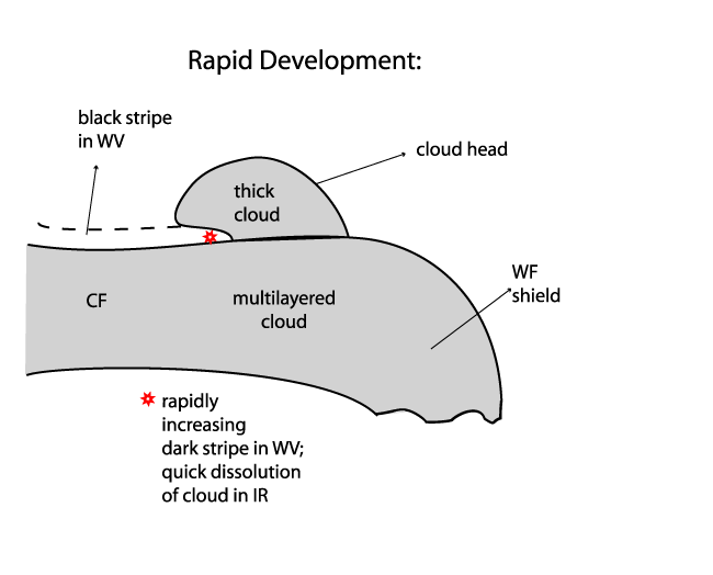
Summary of typical cloud features
The main features in satellite imagery indicating the processes of a "Rapid Cyclogenesis" are (for more information compare manual Conceptual Models: Rapid Cyclogenesis ):
- During the initial stage of "rapid cyclogenesis" the following typical cloud structures can be identified:
- An (often zonally oriented) multilayered frontal cloud band associated with a baroclinic zone;
- A Warm Front Shield towards the front of the frontal cloud band;
- A cloud bulge protruding from below the frontal cloud band into the cold air consisting of lower clouds; this is indicative of an existing Wave;
- A Dark Stripe in WV imagery, along the cold side of the frontal cloud band, indicating sinking dry air with high values of PV;
- Indications for an imminent start of rapid deepening can be:
- A rapidly increasing Dark Stripe in IR and WV to the rear of the low cloud head;
- Strong negative values in motion corrected difference images (see Basics: Satelllite Channels - Artificial and Combination Channels ) indicating the drying of descending air as well as a decay in cloudiness.

|
|
Lothar and Lothar successor
Analysis of Lothar from satellite features
|
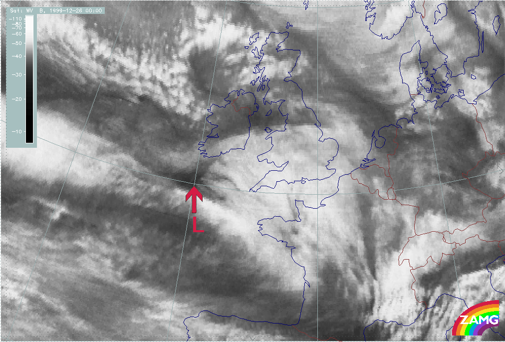
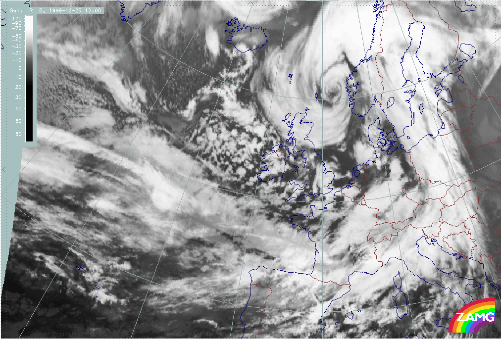
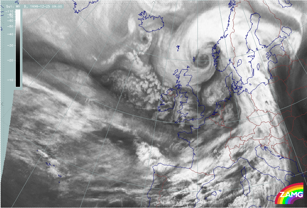
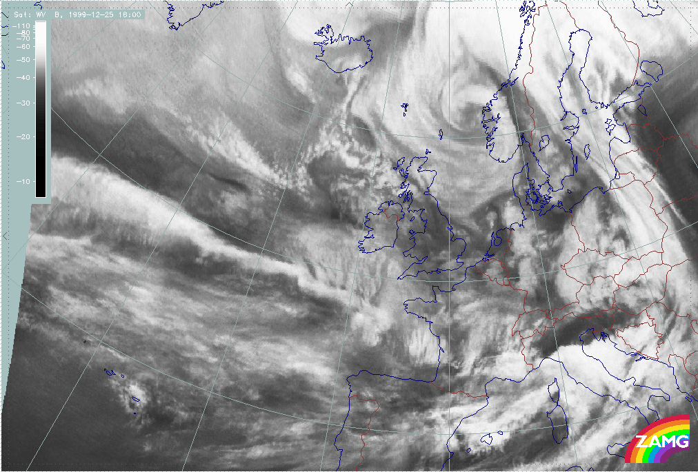
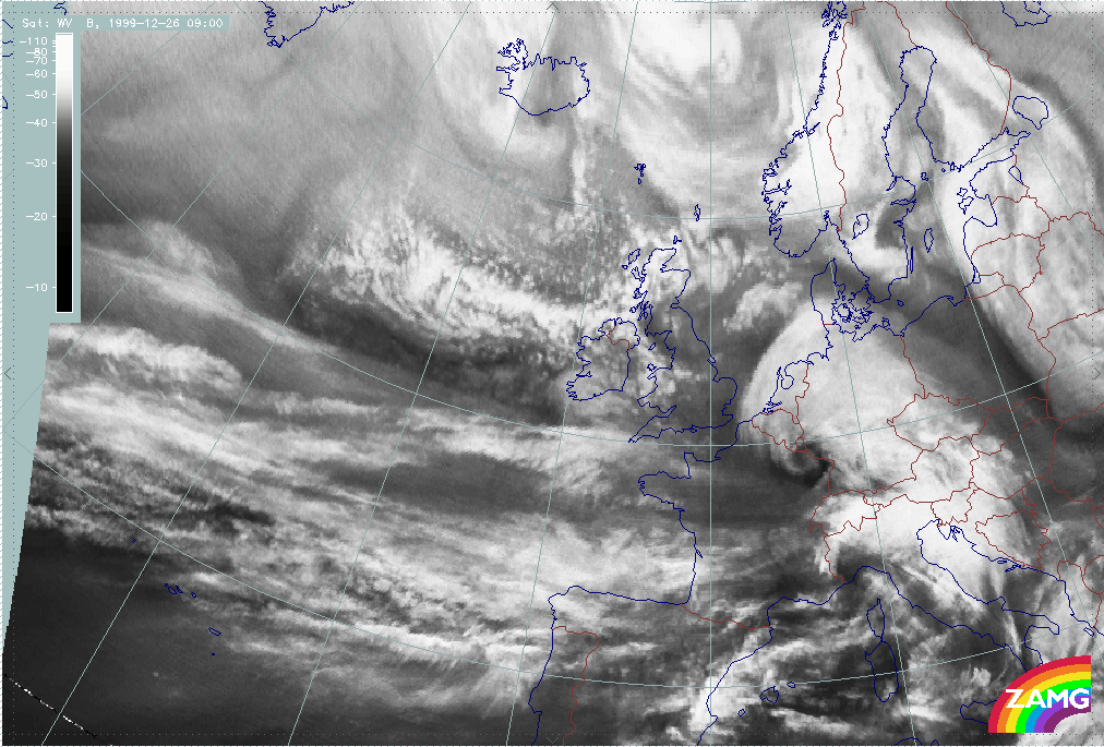
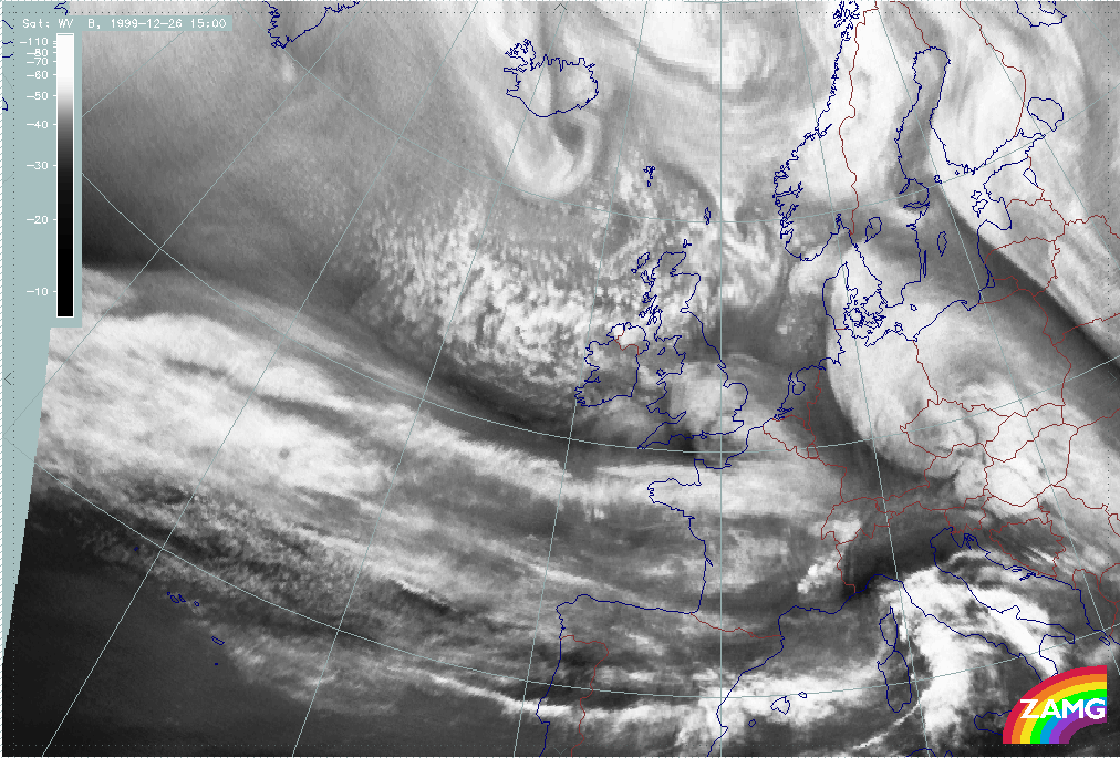
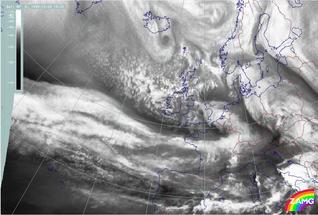
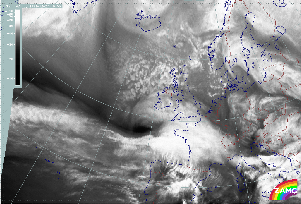
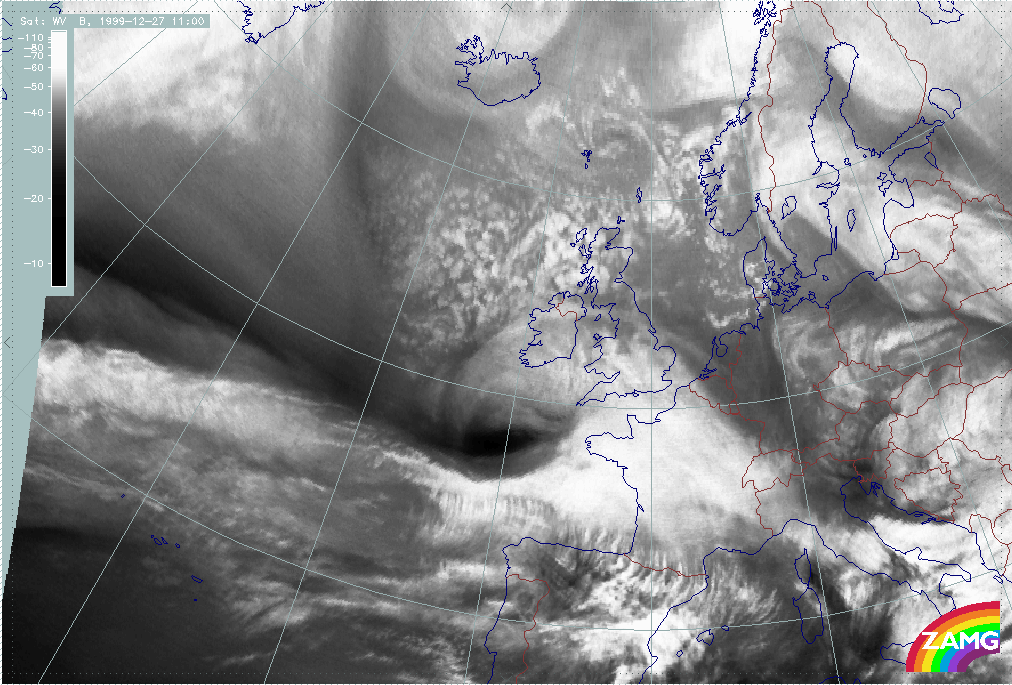
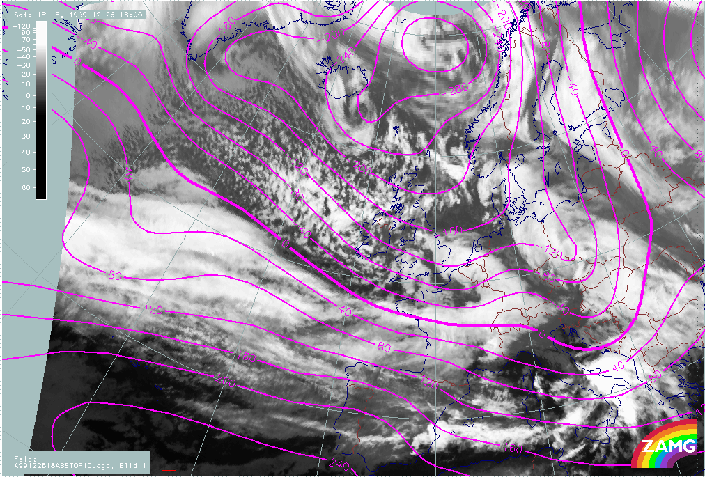
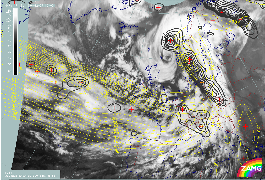
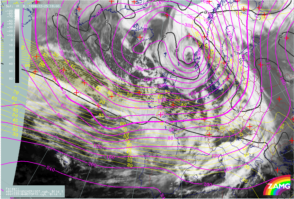
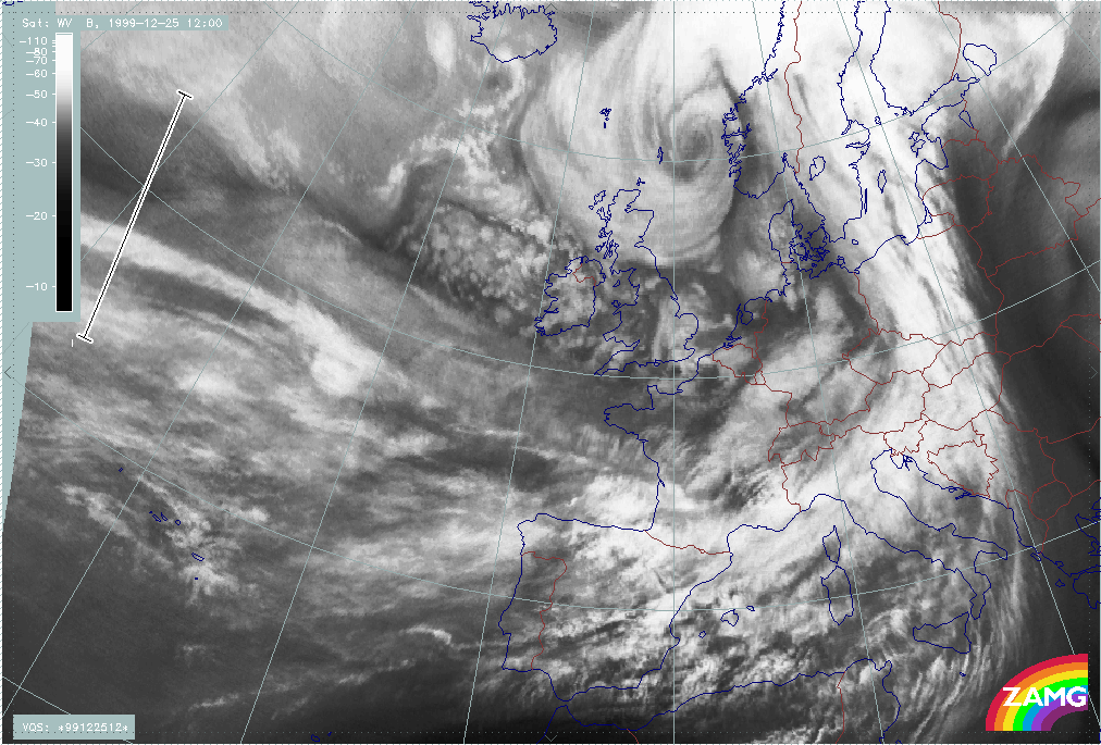
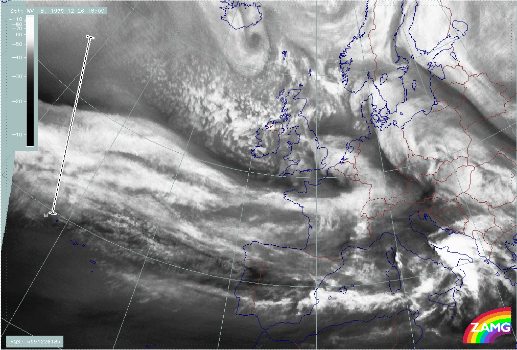
25 December 1999/06.00 UTC - Meteosat IR image; 25/06.00 - 26/00.00 UTC 3-hourly image loop
|
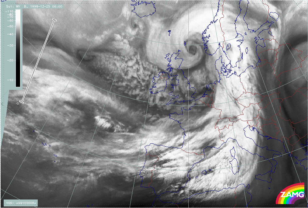
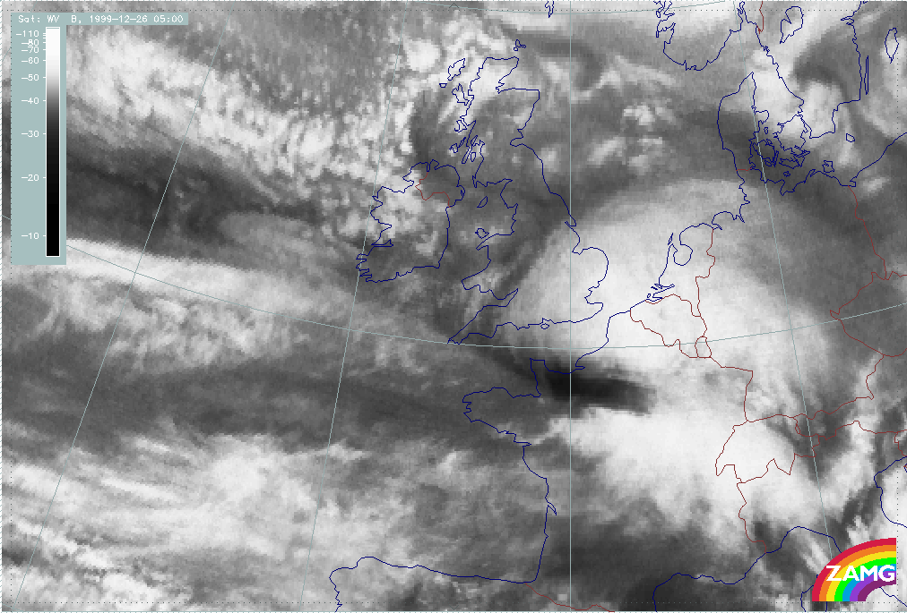
25 December 1999/06.00 UTC - Meteosat WV image; 25/06.00 - 26/00.00 UTC 3-hourly image loop
|
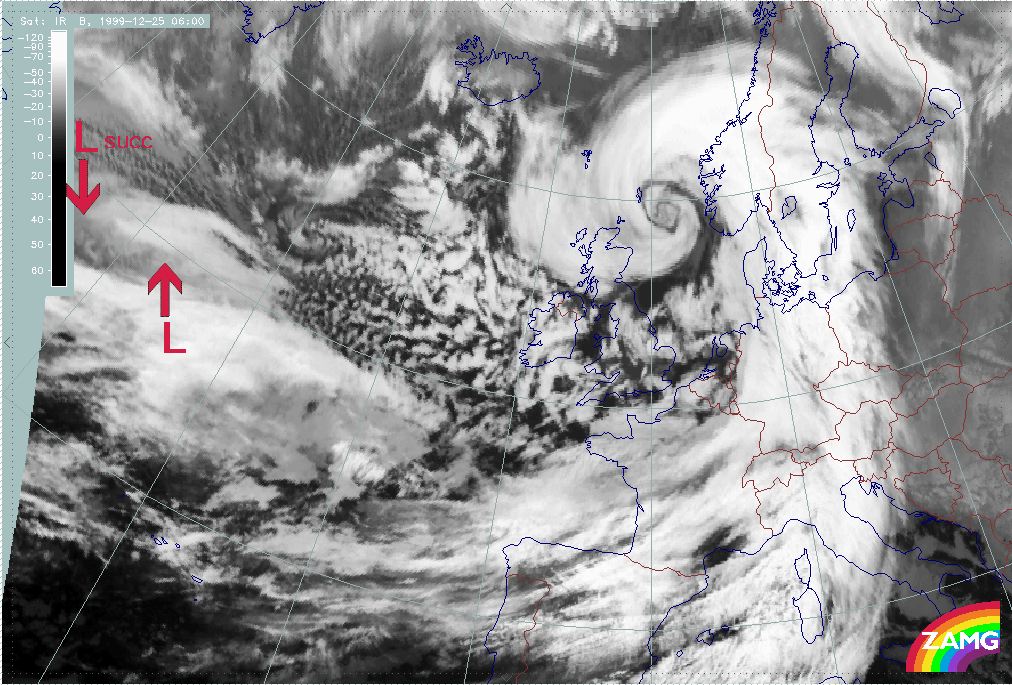
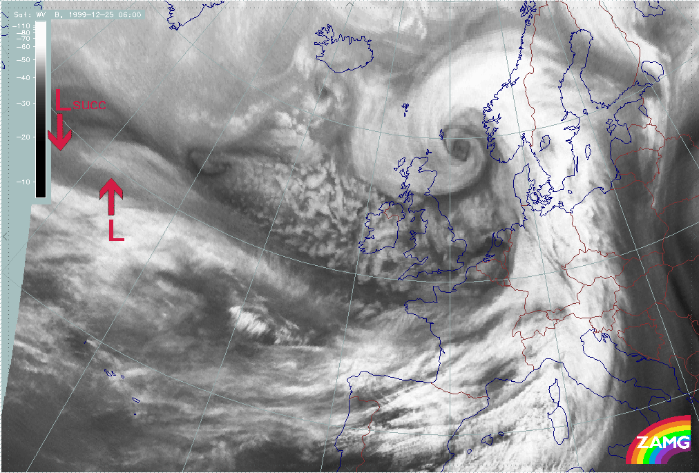
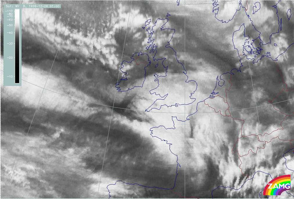
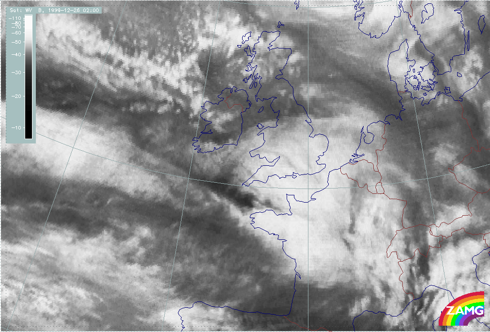
Summary of typical, yet important features in IR and WV imagery for the initial stage of Lothar:
- A broad zonal frontal cloud band, highly structured and composed of cloud fibres at different heights above lower denser cloud fields, extends zonally across the Atlantic;
- The Warm Front Band cloud does not differ much from the main frontal cloud band;
- A "cloud head" exists from the very beginning: this is a lower cloud part penetrating below the zonal front band in direction of the cold air (see red arrow in left hand image). This is not yet a fully developed cloud head of "Rapid Cyclogenesis" but it does indicate possible areas for a Wave and a subsequent rapid development;
- In the case of Lothar the frontal cloud decays immediately to the rear of the low cloud head and close to the rapid development (25/12.00 - 21.00 UTC);
- The WV images show a Dark Stripe at the rear of and along the broad frontal cloud; in the beginning there appears to be a double structure, the more northern black line becomes a feature associated with a subsequent development ("Lothar successor" see below).
- Such a situation can persist for some time until fast "Rapid Cyclogenesis" starts. This happened on 26 December from 00.00 UTC on.
|
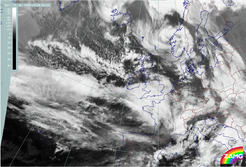
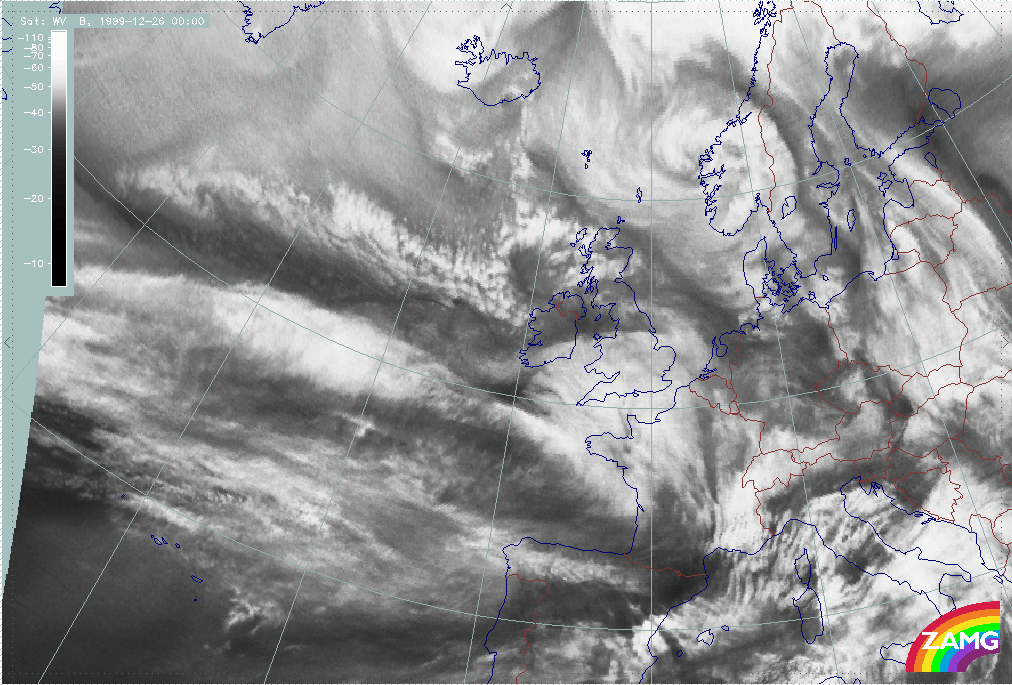
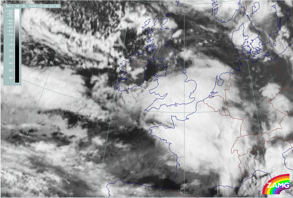
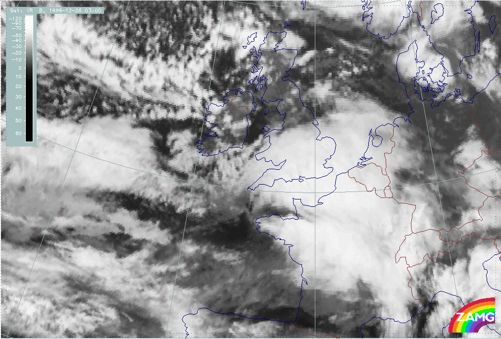
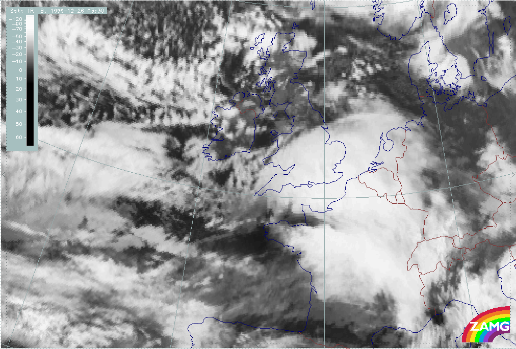
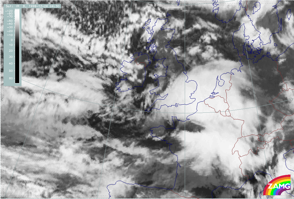
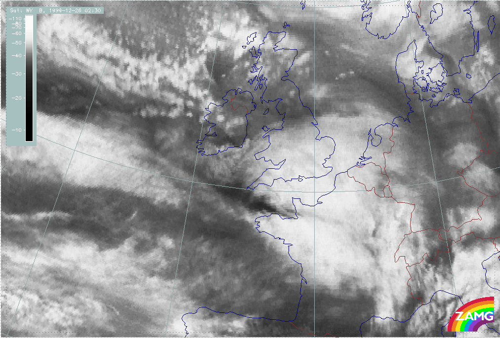
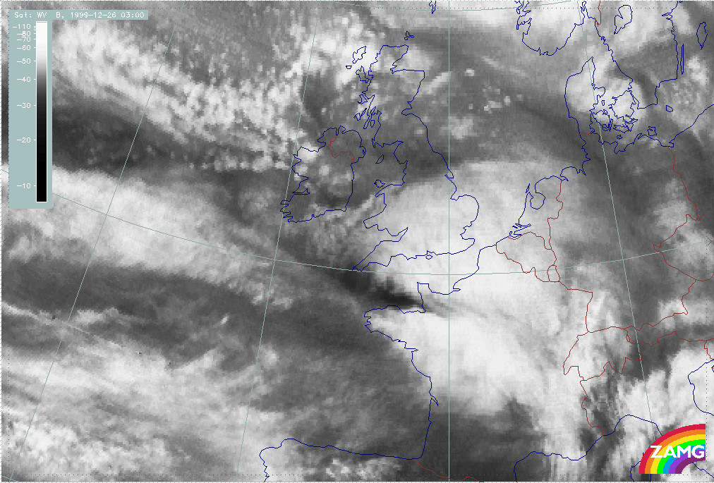
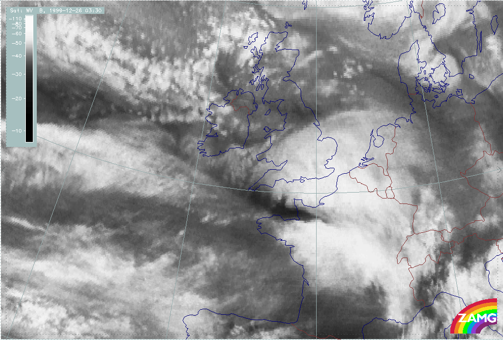
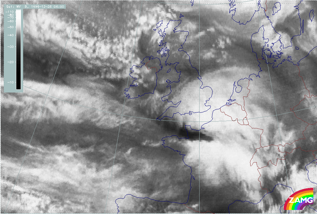
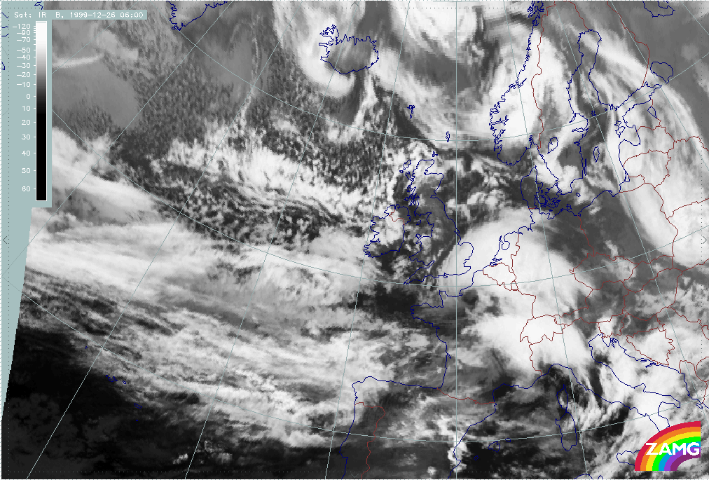
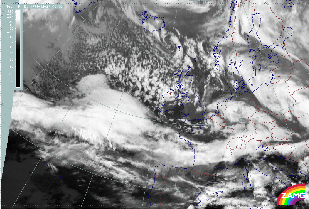
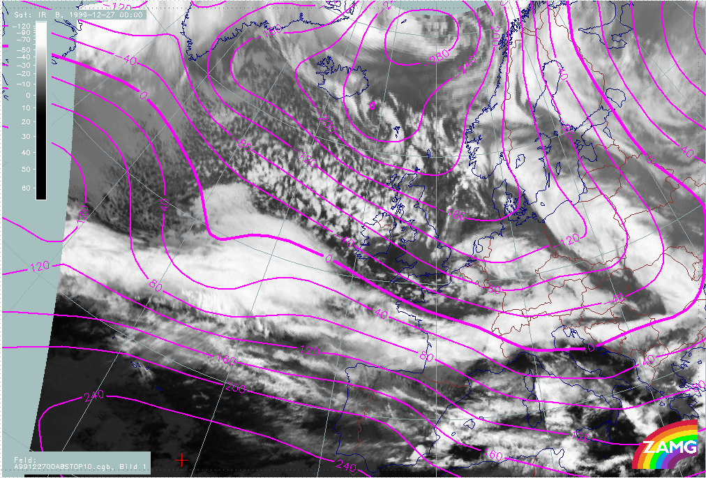
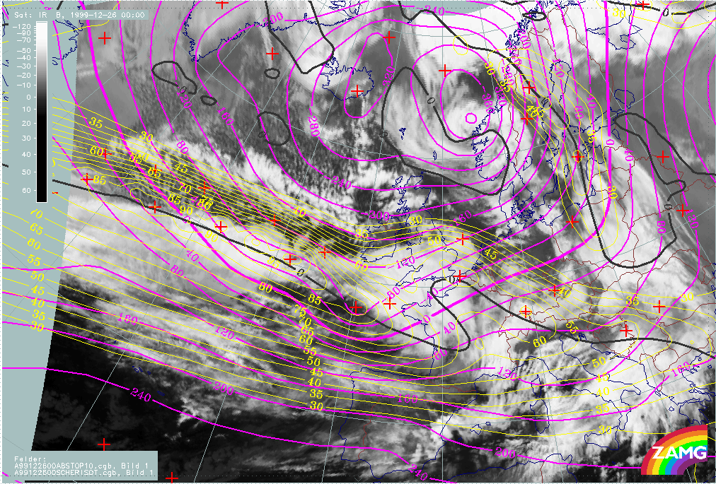
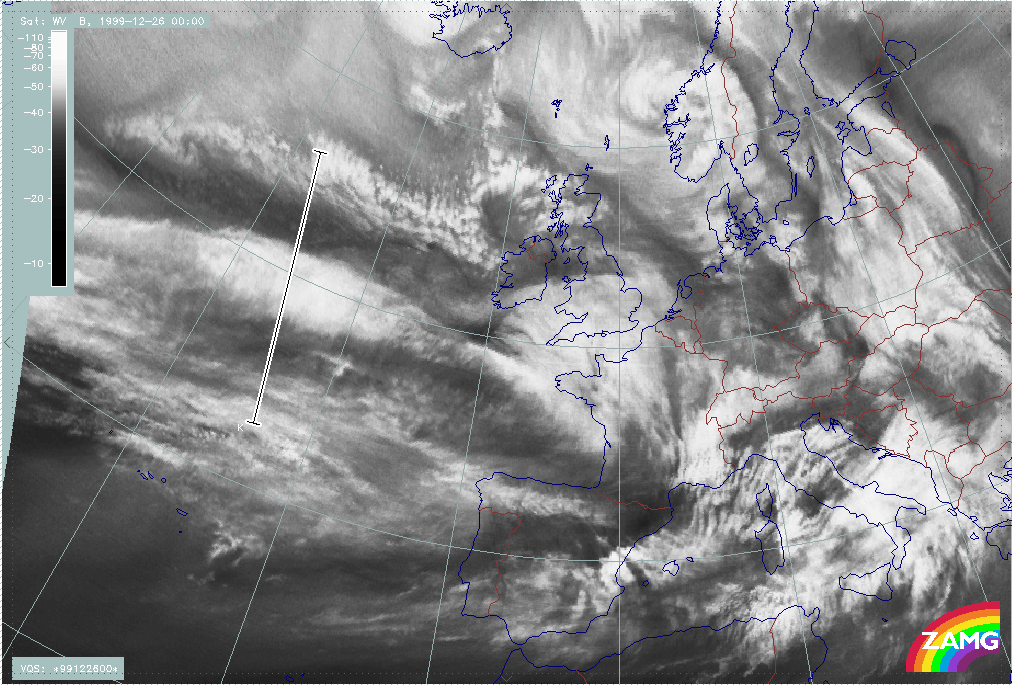
26 December 1999/00.00 UTC - Meteosat IR image; 00.00 - 06.00 UTC half-hourly image loop
|
26 December 1999/00.00 UTC - Meteosat WV image; 00.00 - 06.00 UTC half-hourly image loop
|
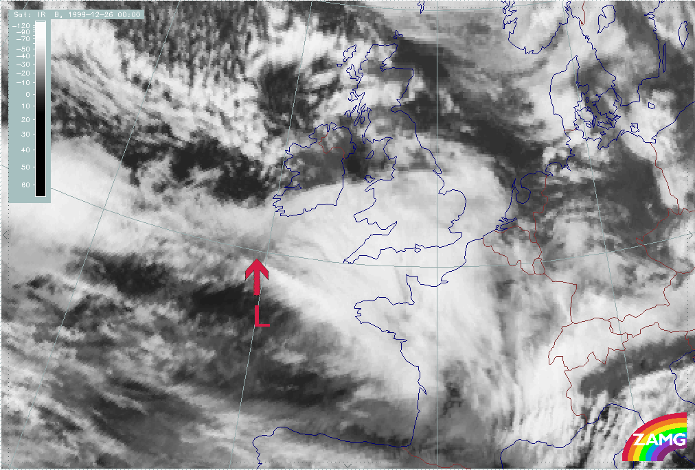
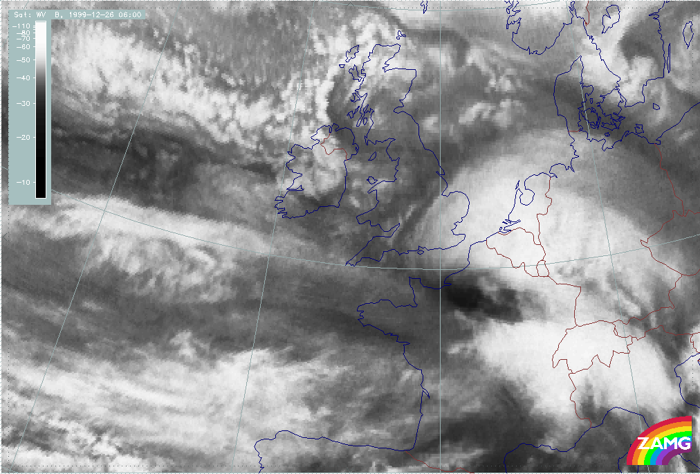
Summary of typical and important features in IR and WV for the fast "Rapid Cyclogenesis" development of Lothar:
- A local darkening (in WV and IR) of an area to the rear of or slightly upstream from the cloud head where the development is going to take place (26/00.00 - 01.00 UTC)
- An intensive development of a Dark Stripe between the zonal cloud band and the cloud head within a very small time scale of several (about 6) hours in both: IR and WV (see region of red arrow);
- The rapid and pronounced intensification of a cloud head (already from 25/18.00 UTC on);
- A subsequent development of a pronounced cloud spiral comprising an increasing black area in the WV.
|
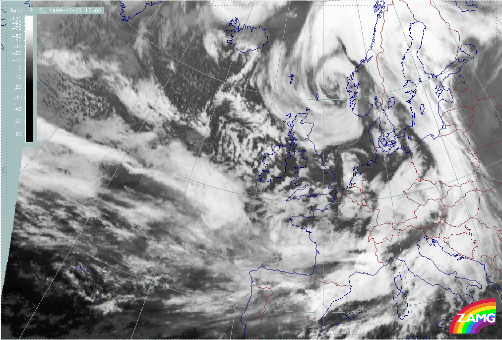
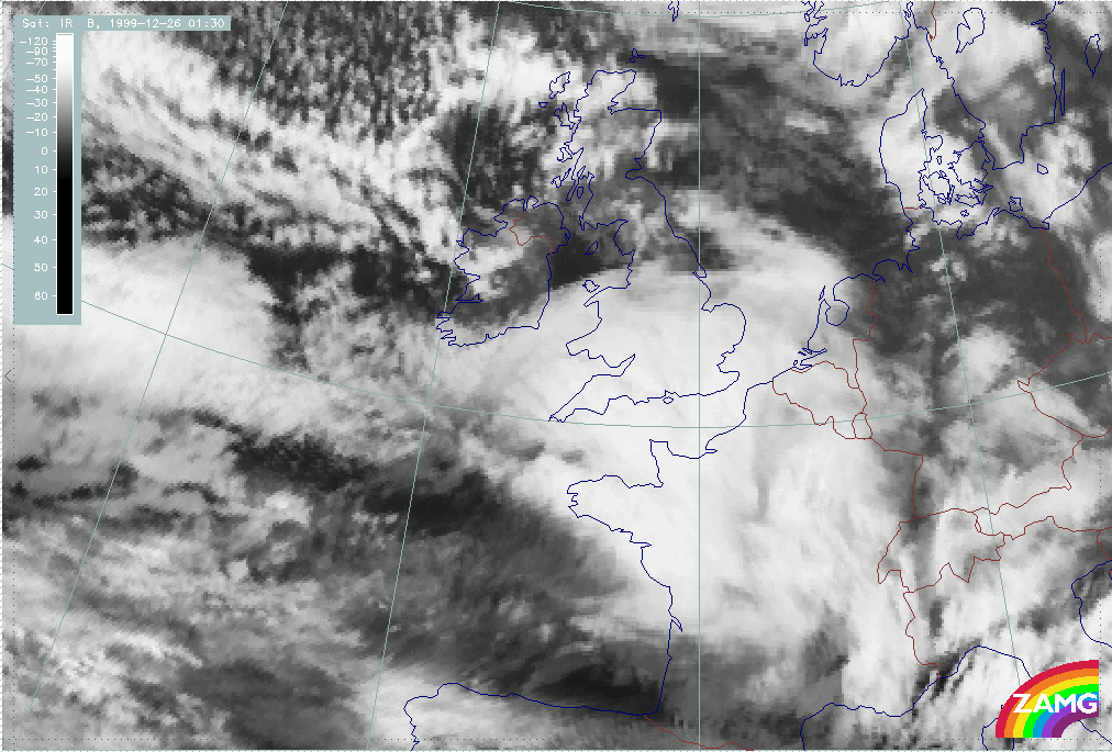
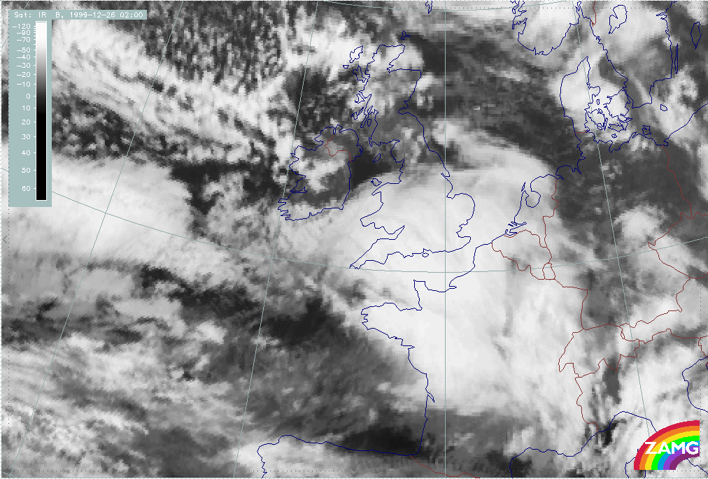
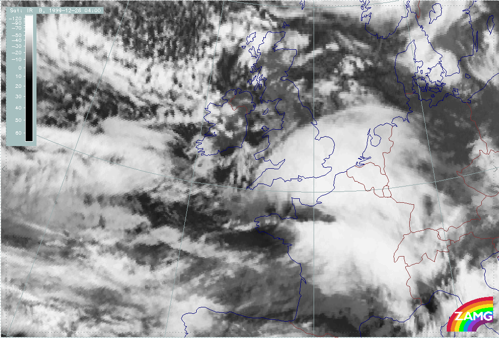
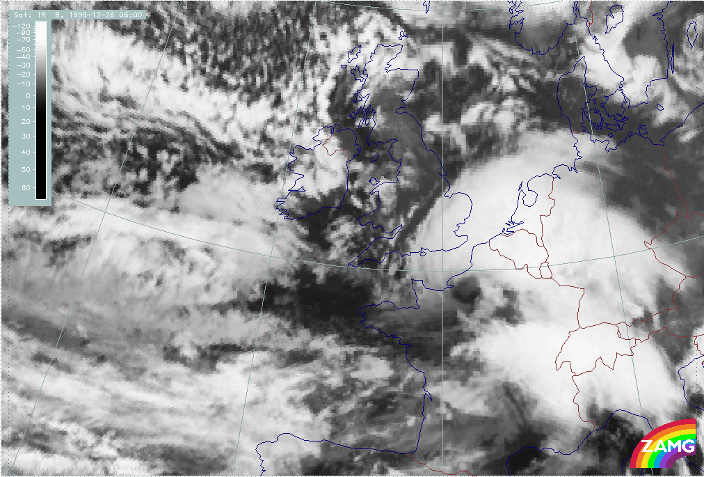
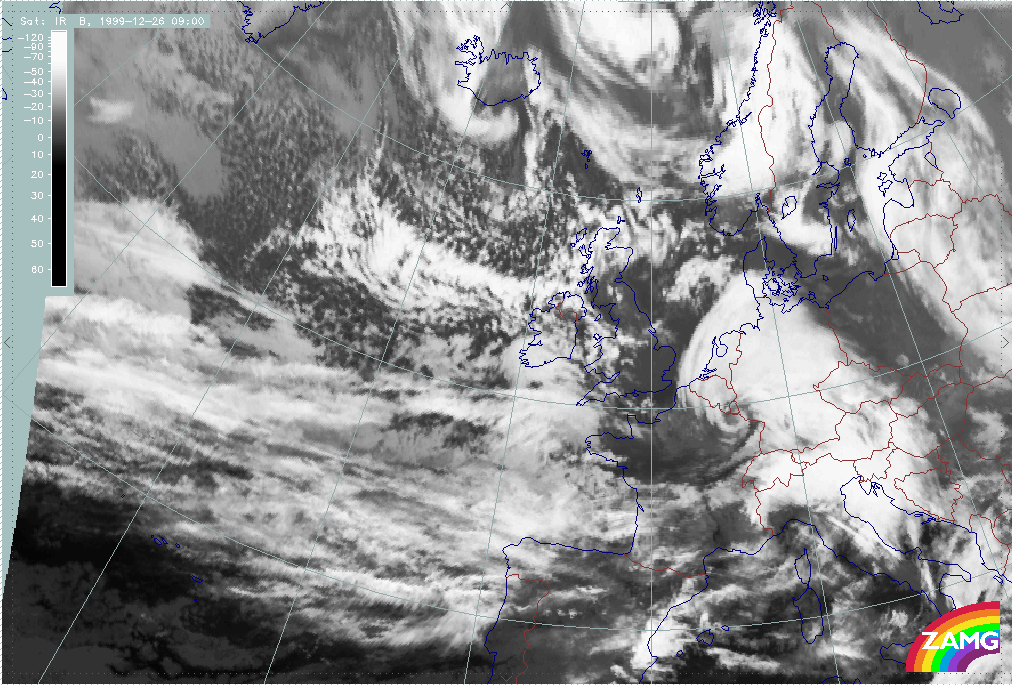
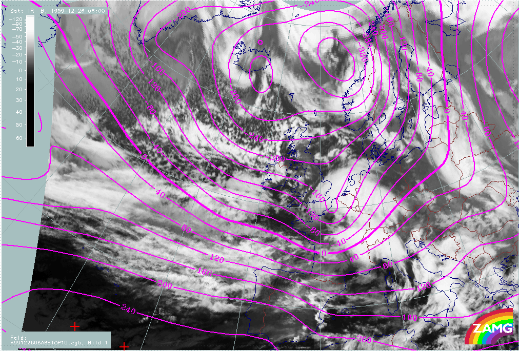
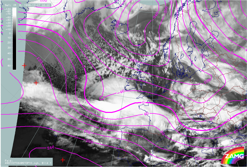
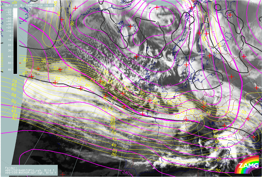
26 December 1999/03.00 UTC - Meteosat IR image; 03.00 - 12.00 UTC 3-hourly image loop
|
26 December 1999/03.00 UTC - Meteosat WV image; 03.00 - 12.00 UTC 3-hourly image loop
|


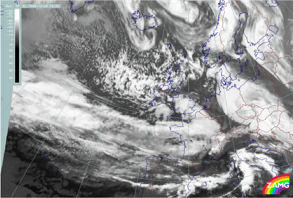
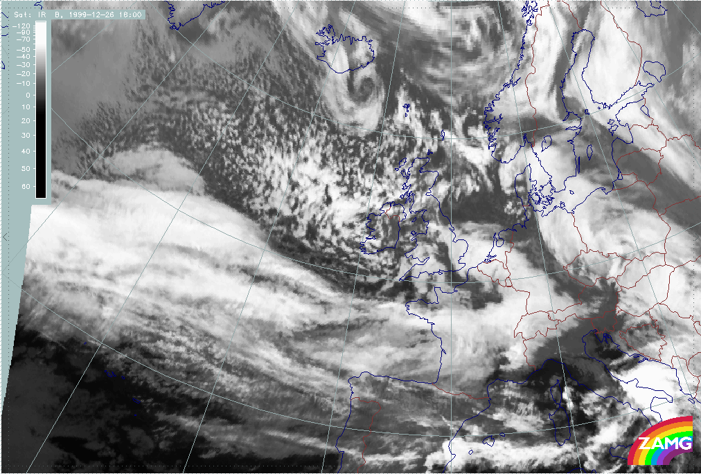
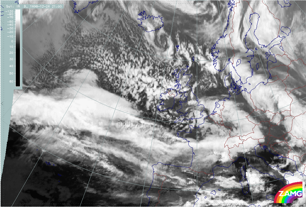
The further "rapid cyclogenesis" development shows:
- The rapid development of a very intensive cloud spiral
- Clouds close to the centre of the surface low (very small scale) can rotate several times around the centre, indicating very high wind speeds (similar to tropical storms);
- A Comma - like but small to mesoscale line of cells often develops in the centre of the low.
Diagnosis of "Lothar successor" from satellite features
|
25 December 1999/06.00 UTC - Meteosat IR image; 25/06.00 - 26/00.00 UTC 3-hourly image loop
|
25 December 1999/06.00 UTC - Meteosat WV image; 25/06.00 - 26/00.00 UTC 3-hourly image loop
|
Summary of typical and important features in IR and WV for the initial stage of Lothar successor:
- "Lothar successor" can be seen from the very beginning in IR images as a substructure in the western part of the low cloud head belonging to Lothar and later as separate (cut off) cold air feature (25 December/06.00 - 15.00 UTC)
- During the same period the WV image shows a pronounced Dark Stripe to the rear of the cloud structure of "Lothar successor"; this WV stripe is much more pronounced than the mere grey shade gradient to the rear of the cloud head belonging to Lothar;
- At 18.00 UTC on 25 December the start of a dramatic change in the WV image can be seen: the area behind the cloud head belonging to Lothar darkens significantly compared to the still dark area behind the cloud head belonging to "Lothar successor"; this is the first indication of the Rapid Cyclogenesis going on within Lothar (see above);
- From 18.00 UTC on 25 December a Wave feature develops in the frontal cloud band in the area of the cloud head belonging to "Lothar successor"; consequently, the bright cloud to the rear of the frontal cloud band is shifted northward and thus partly hides the lower cloud bulge.
Loop of 3-hourly images from 26 December 12.00 till 21.00 UTC shows the further development of "Lothar successor"
|
26 December 1999/03.00 UTC - Meteosat IR image; 03.00 - 12.00 UTC 3-hourly image loop
|
26 December 1999/03.00 UTC - Meteosat WV image; 03.00 - 12.00 UTC 3-hourly image loop
|
The following features can be summarised:
- Although there are some features which are indicative of rapid development, no such development takes place.
- Between 26 December 03.00 - 09.00 UTC there is a dissipation of the frontal cloud band close to the area of the cloud head of "Lothar successor" - a process which could also be observed with Lothar;
- Between 26 December 06.00 and 09.00 UTC, there is a distinct darkening in the WV image, immediately behind the cloud head belonging to "Lothar successor"; this could be regarded as the start of "Rapid Cyclogenesis";
- But: instead of a dissipation of cloudiness in the cloud head and a subsequent intensive spiral development, a rather weak spiral, typical of a Comma develops.
- This spiral increases somewhat but remains at meso-scale; there are extensive cold air features behind.
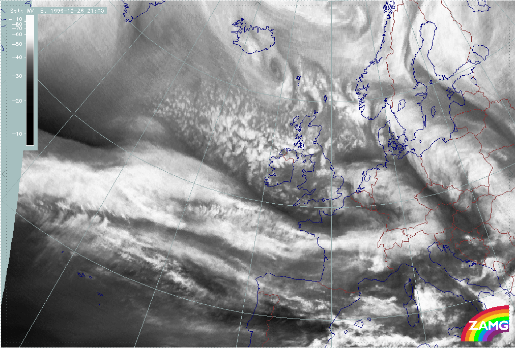
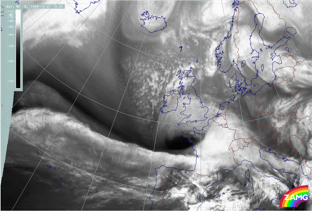
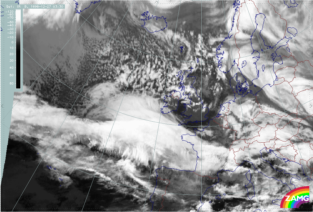
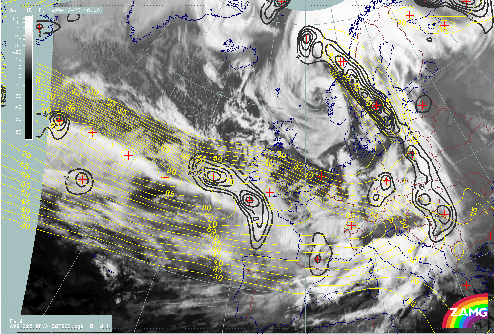
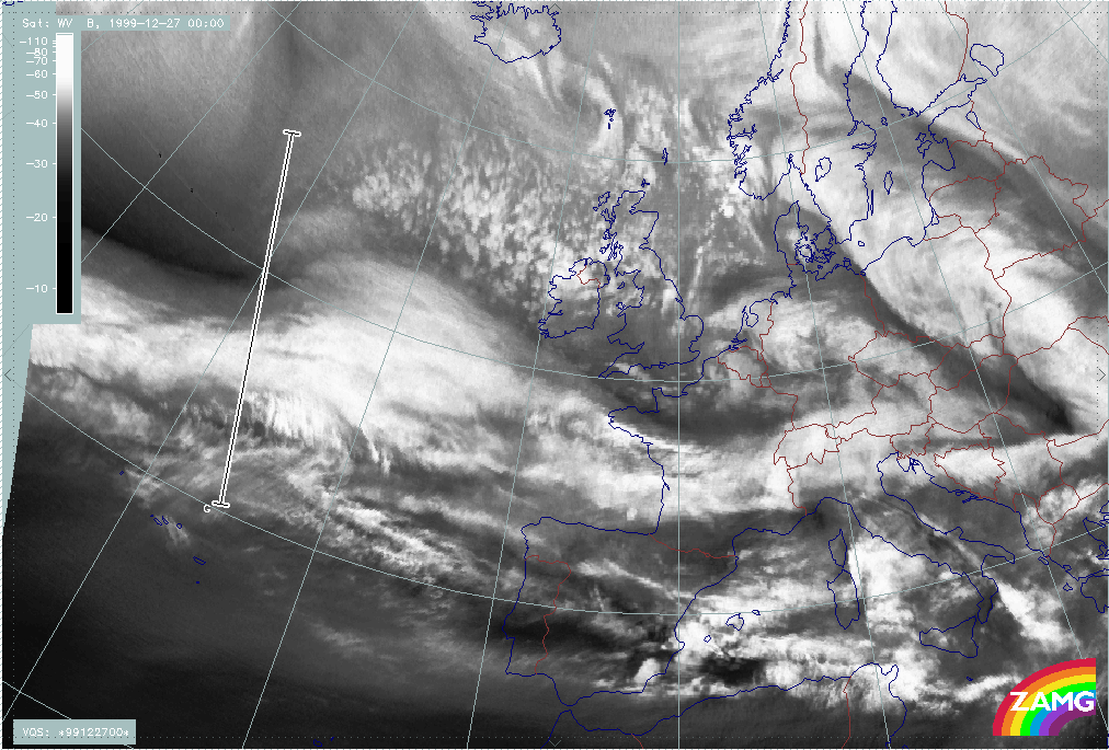
Martin
Analysis of Martin from satellite features
|
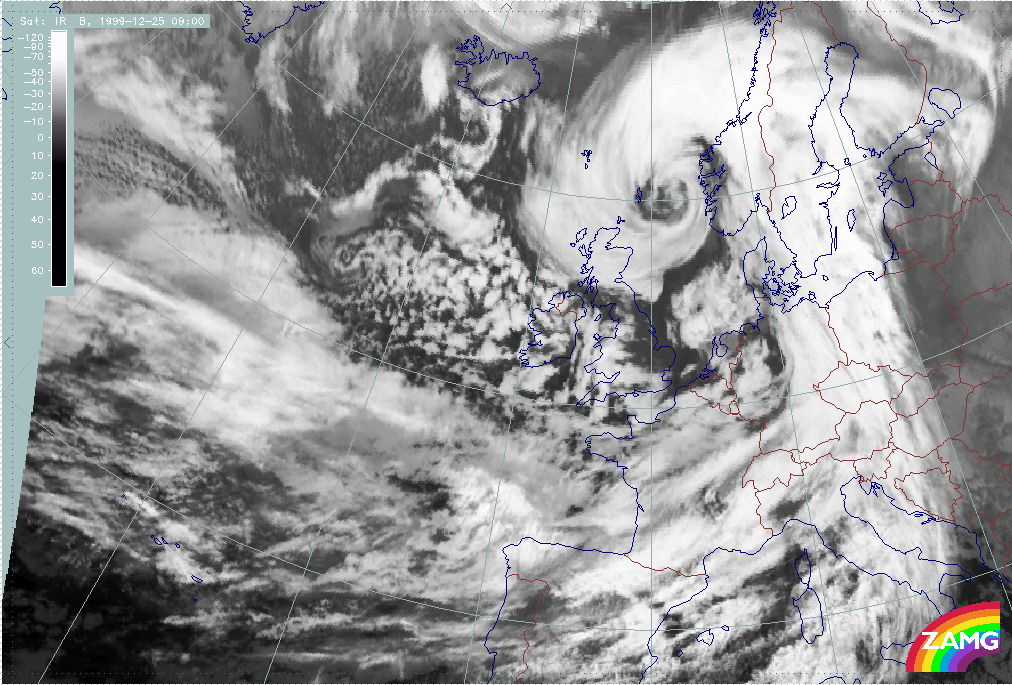
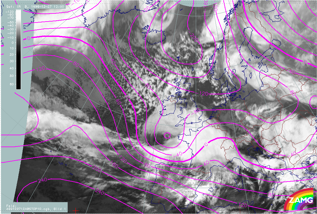
26 December 1999/12.00 UTC - Meteosat IR image; 26/12.00 - 27/18.00 UTC 3-hourly image loop
|
26 December 1999/12.00 UTC - Meteosat WV image; 26/12.00 - 27/18.00 UTC 3-hourly image loop
|
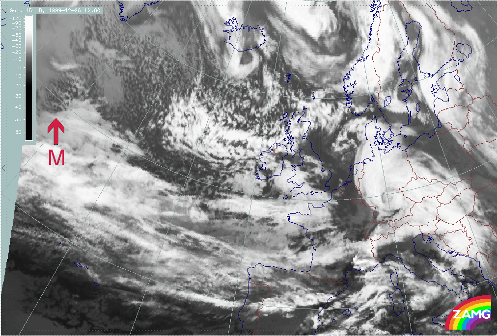
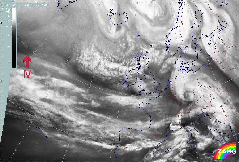
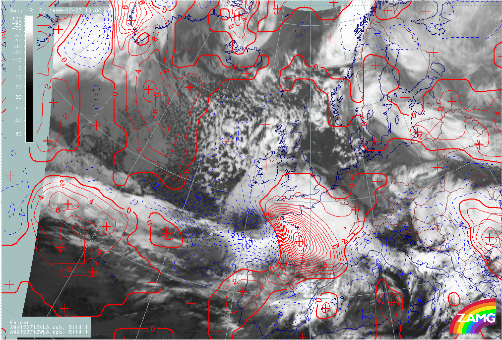
Summary of typical and important features for Martin:
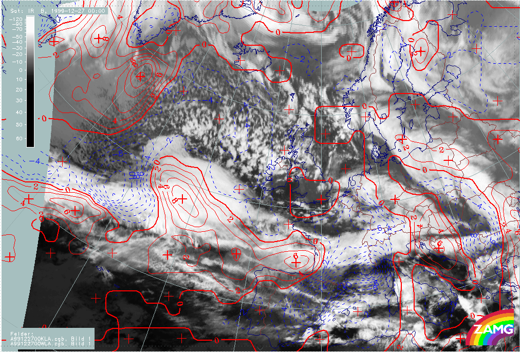
- The development of Martin appears within the same broad frontal cloud band as Lothar and Lothar successor;
- A "cloud head" exists from the very beginning: this is a lower cloud part penetrating below the zonal front band in the direction of the cold air. This is not yet the typical pronounced cloud head of "Rapid Cyclogenesis" in its mature stage of development but it does indicate possible areas for a Wave and a later development;
- The WV image shows a Dark Stripe to the rear of and along the broad frontal cloud;
- Such a situation can last some time till the "Rapid Cyclogenesis" development starts;
- In the case of Martin, there is a splitting of the "low cloud shield" at the western boundary leading to an independent cold air cloud like an EC or Comma, probably maintained by a PVA maximum ahead of an upper level trough (rather similar to Lothar and Lothar successor).
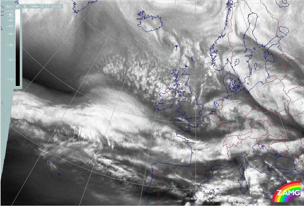
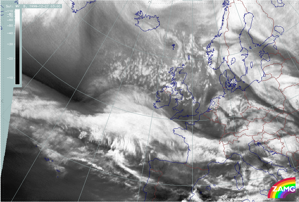
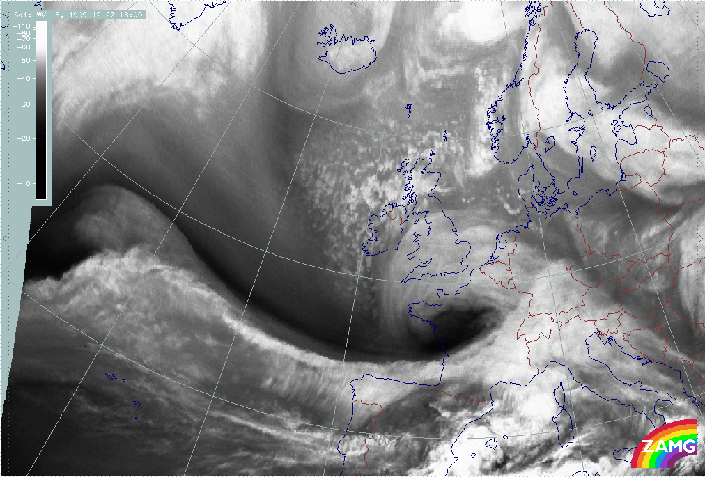
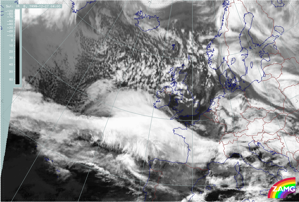
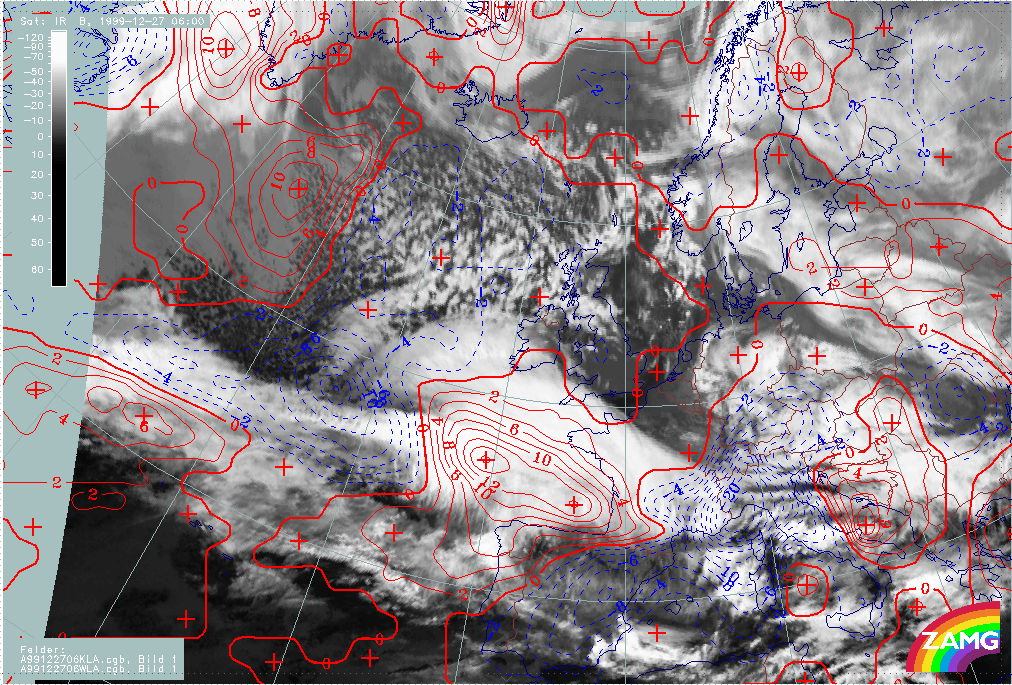
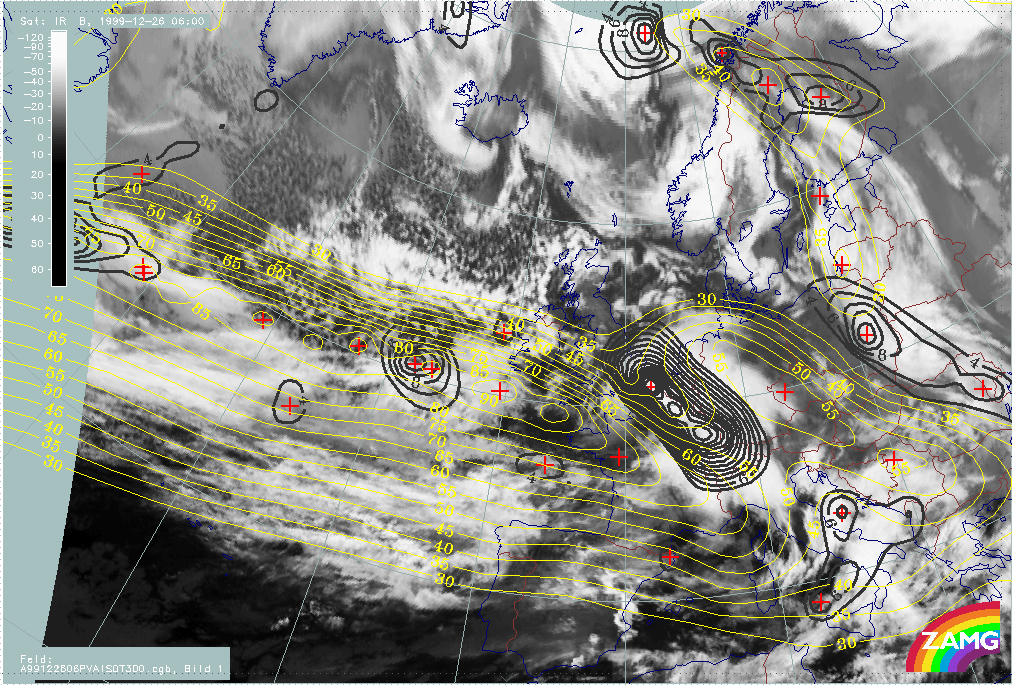
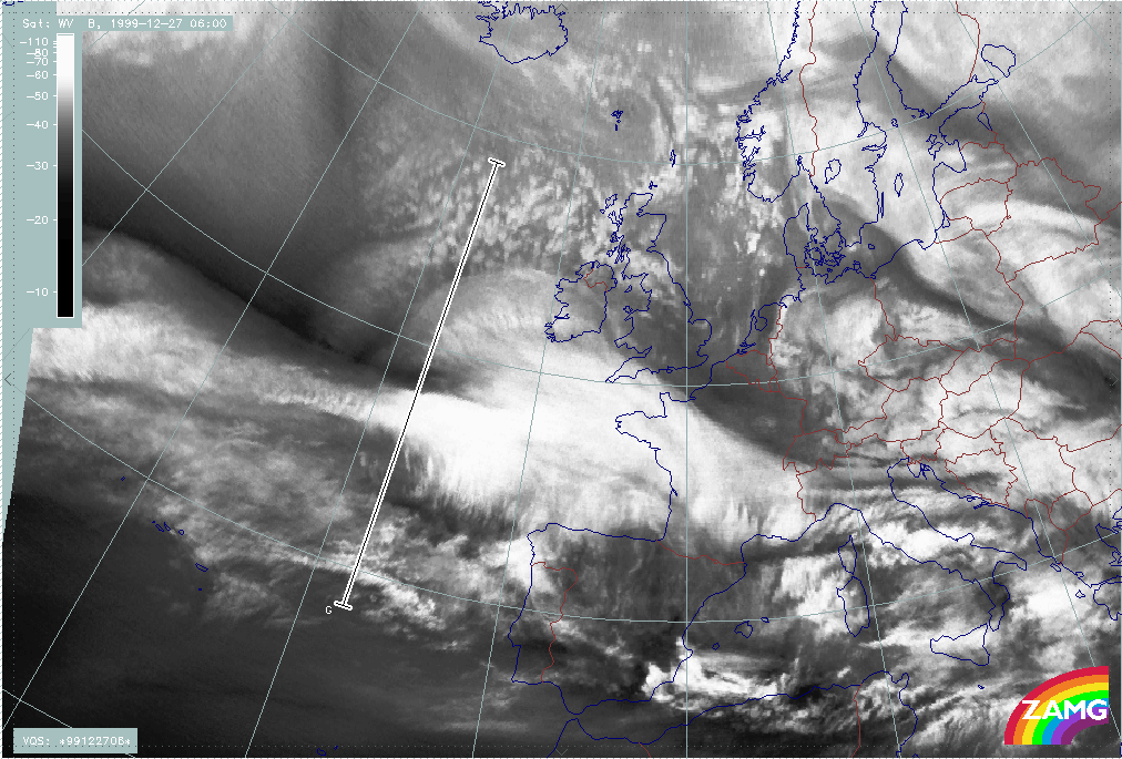
The two 1/2 hourly image loops below show the period where the fast development takes place:
|
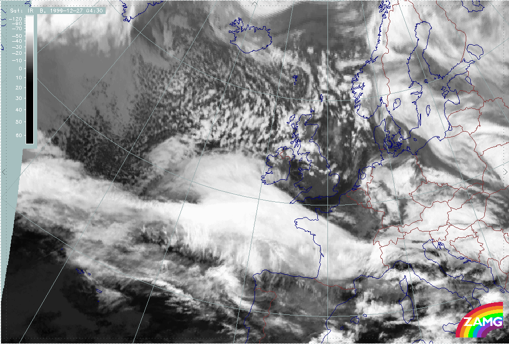
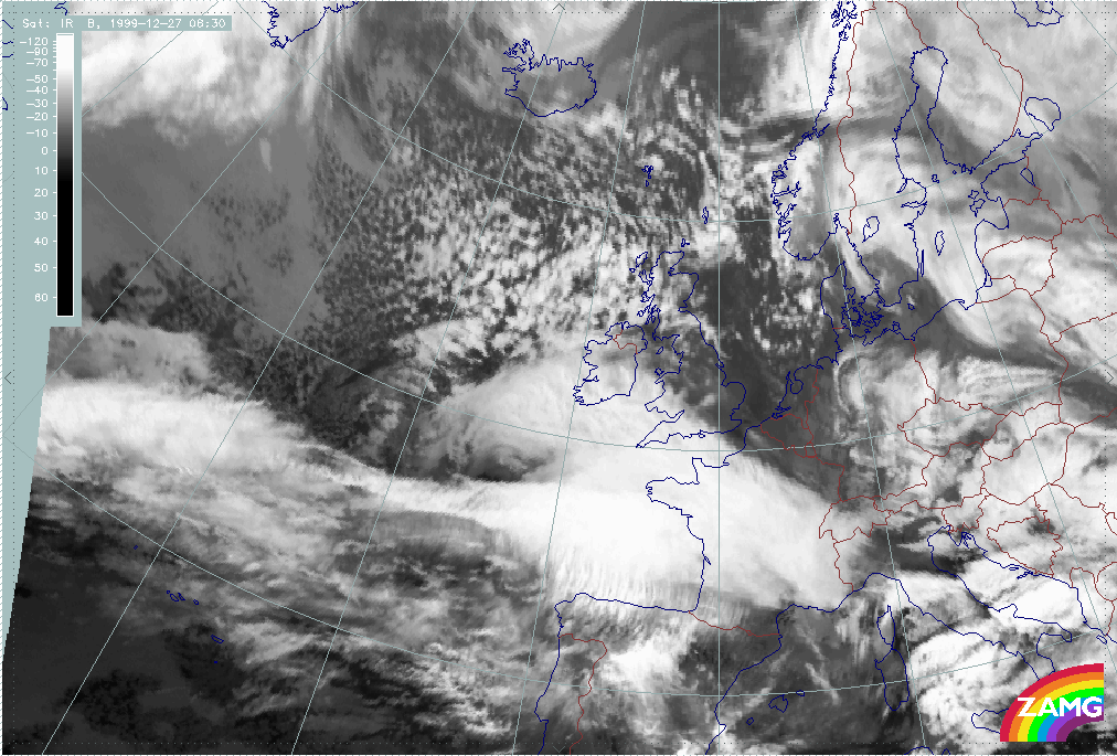
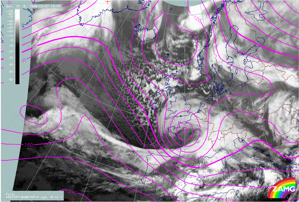
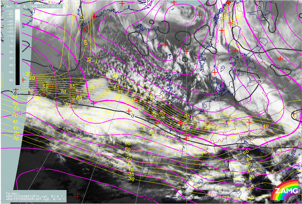
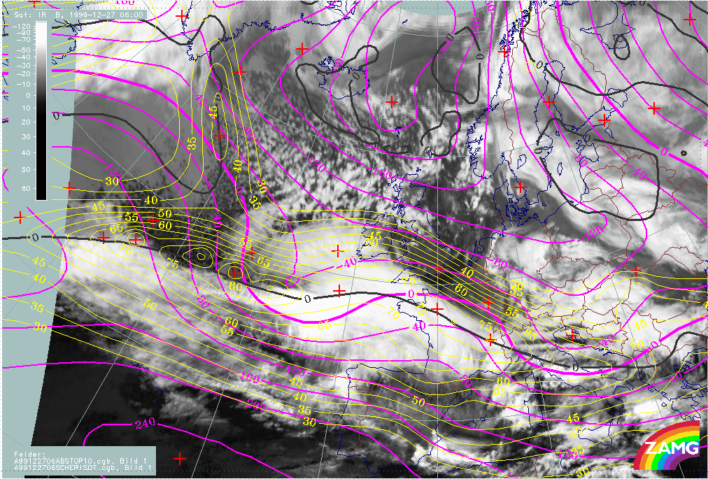
27 December 1999/03.00 UTC - Meteosat IR image; 03.00 - 06.00 UTC half-hourly image loop
|
|
|
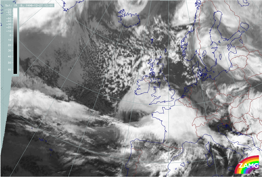
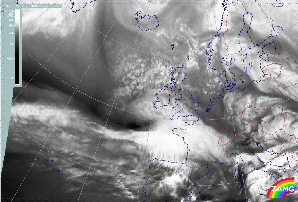
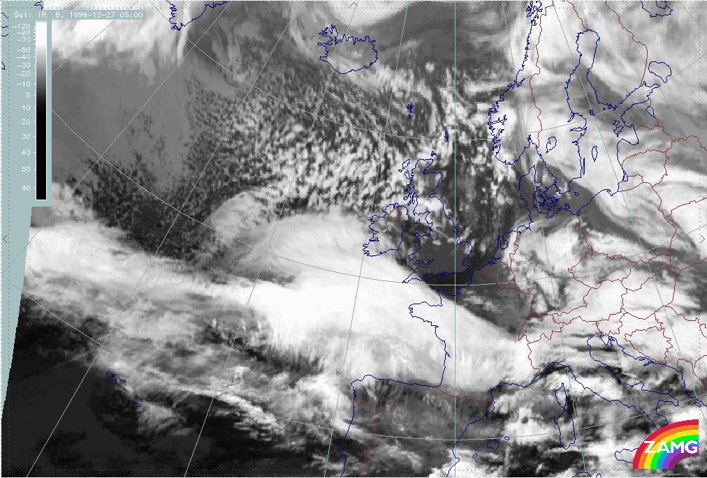
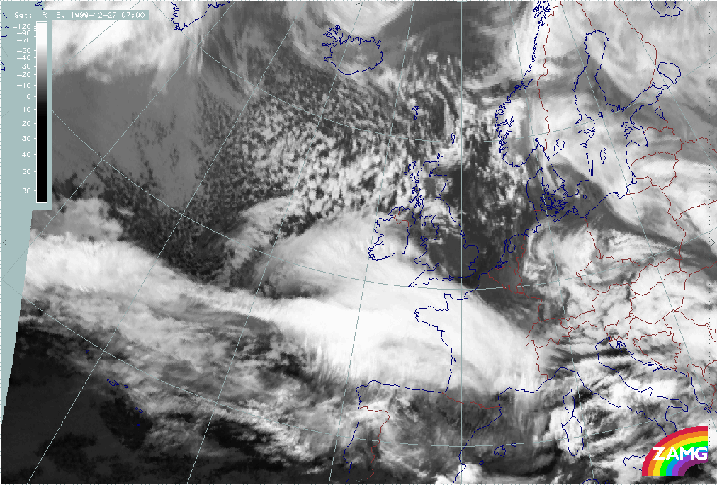
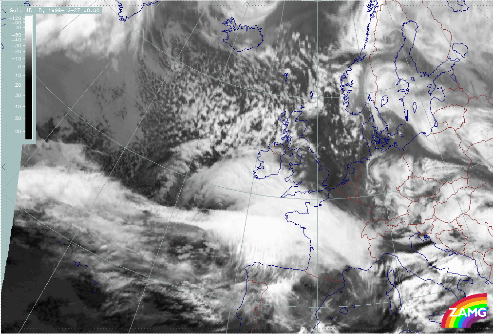
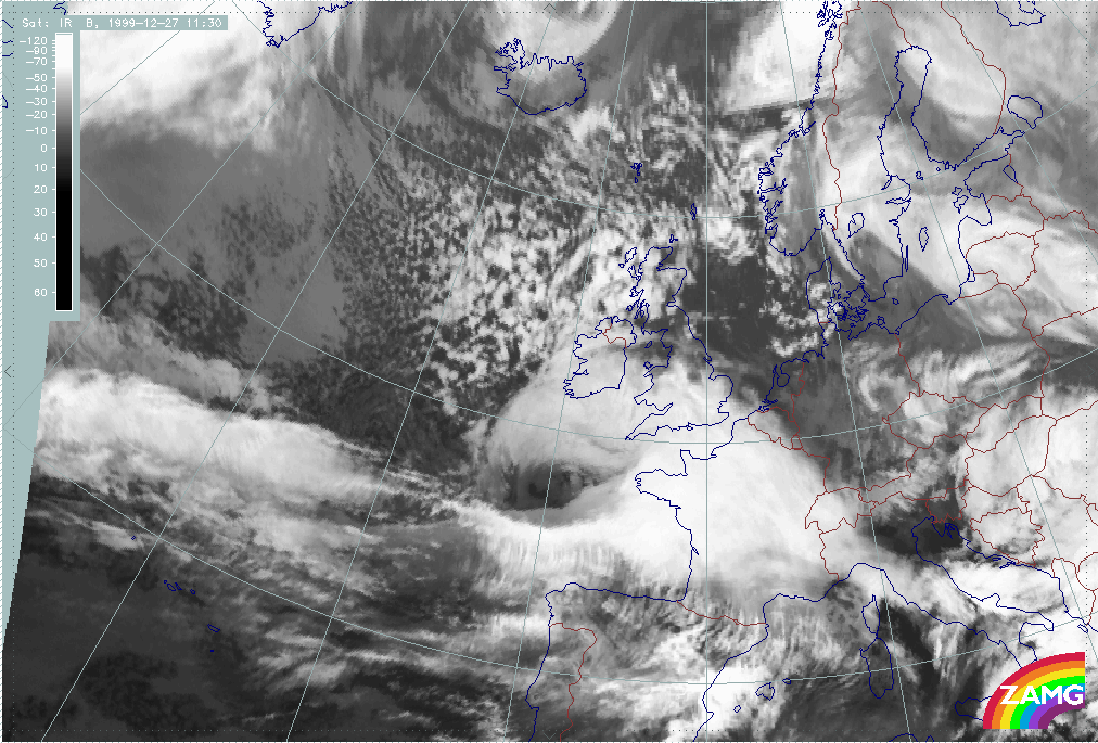
27 December 1999/06.00 UTC - Meteosat IR image; 06.00 - 11.30 UTC half-hourly image loop
|
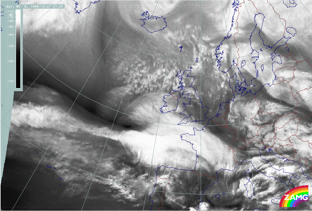
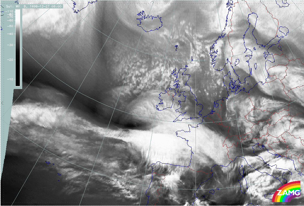
27 December 1999/06.00 UTC - Meteosat WV image; 06.00 - 11.00 UTC hourly image loop
|
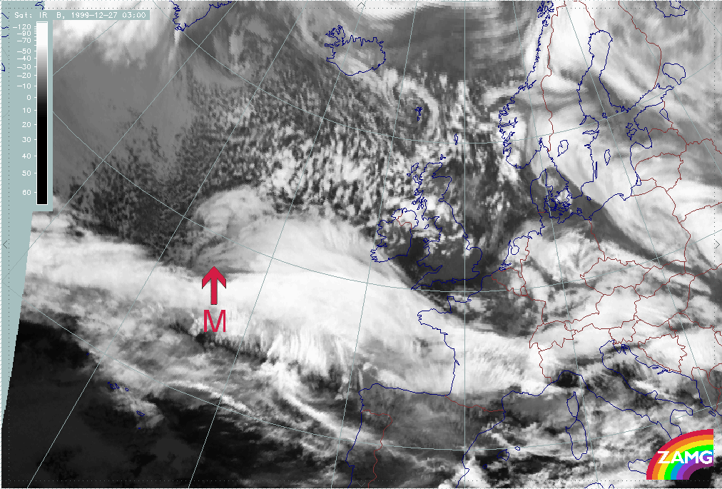

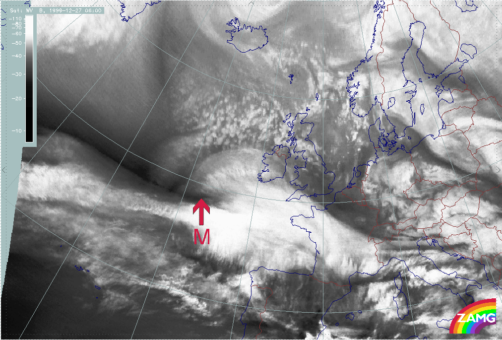
- During rapid development there is:
- A rapid development of an intense Dark Stripe between the zonal cloud band and the cloud head within a time scale of about 6 hours in both: IR and WV;
- A fast and pronounced intensification of a cloud head;
- A subsequent development of a pronounced cloud spiral containing an increasing very dark area in the WV image.
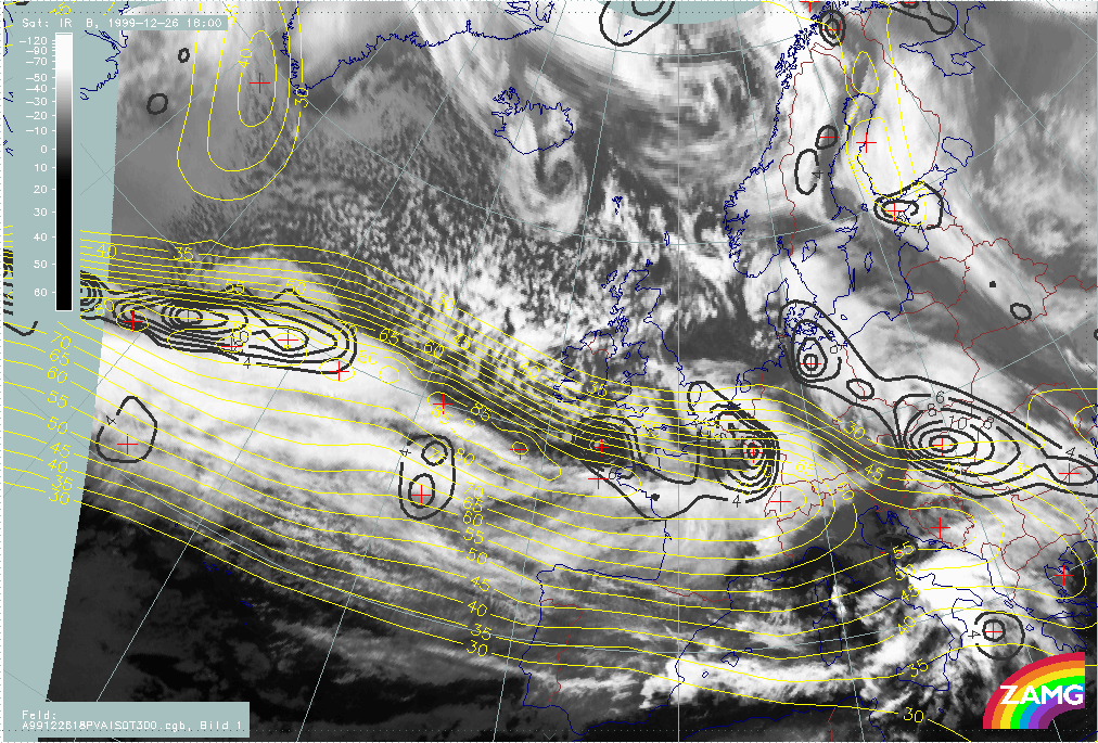
- Further development shows:
- Cloud in the innermost part of the low (at very small scale) rotates several times around the centre which is an indication of very high wind speed (similar to tropical storms); this is not as pronounced as for Lothar and can be seen only in the low cloud;
- A Comma - like, small to mesoscale line of cells develops near the centre of the surface low; again, this is not as distinct as for Lothar.
Baroclinic zone and surface wave
A "Rapid Cyclogenesis" is a rapidly deepening storm which can be enlightened from different points of view. In this chapter, the pre-existing baroclinic zone and Wave are studied. All numerical parameter fields are computed from model analysis fields.
Prior to the start, a frontal zone with a (sometimes only shallow) surface Wave must be present. Such Waves are reflected in the height fields at lower levels, but also show up in temperature advection fields where there is a juxtaposition of WA and CA maxima (see Conceptual Models: Wave ). Upper level troughs coupled with PVA in the area of the front provide further hints for likely Wave development.
Lothar and Lothar successor
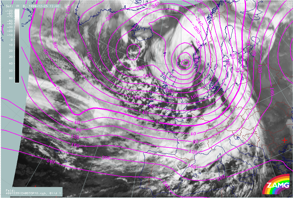
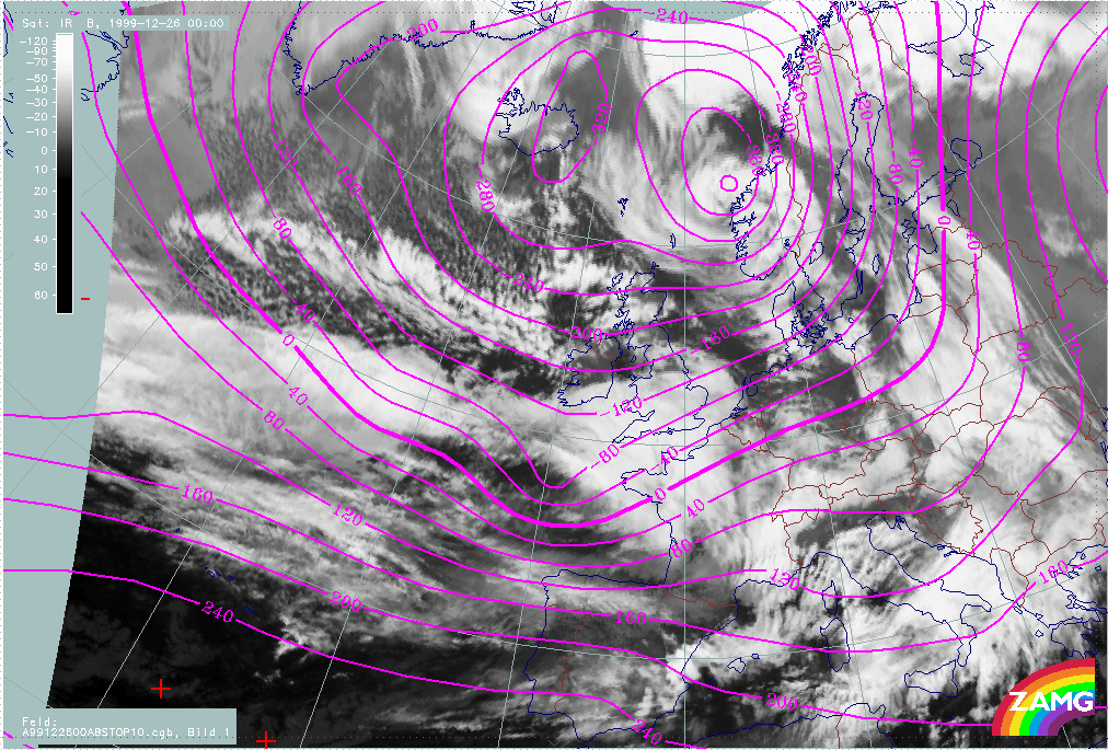
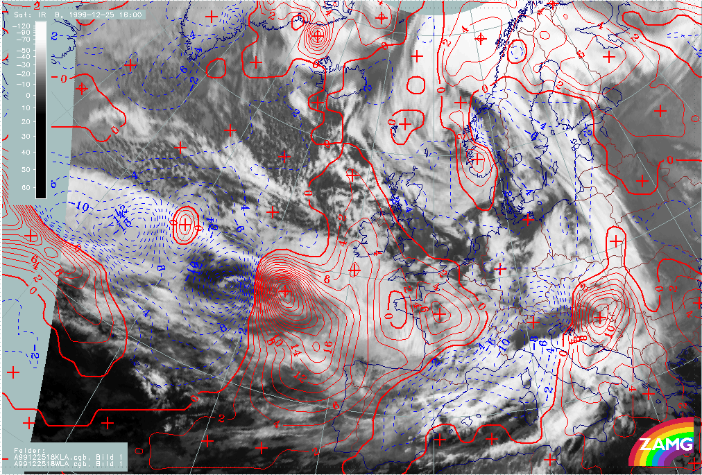
A loop showing changes in surface height at 1000 hPa, from 25 December/06.00 UTC to 26 December/12.00 UTC, shows: the deepening of the surface low corresponding to Lothar, a weak and not intensifiying surface trough corresponding to Lothar successor and the relationship between the surface lows and typical cloud features.
|
25 December 1999/06.00 UTC - Meteosat IR image; magenta: height contours 1000 hPa; 25/06.00 - 26/12.00 UTC 6-hourly image loop
|
|
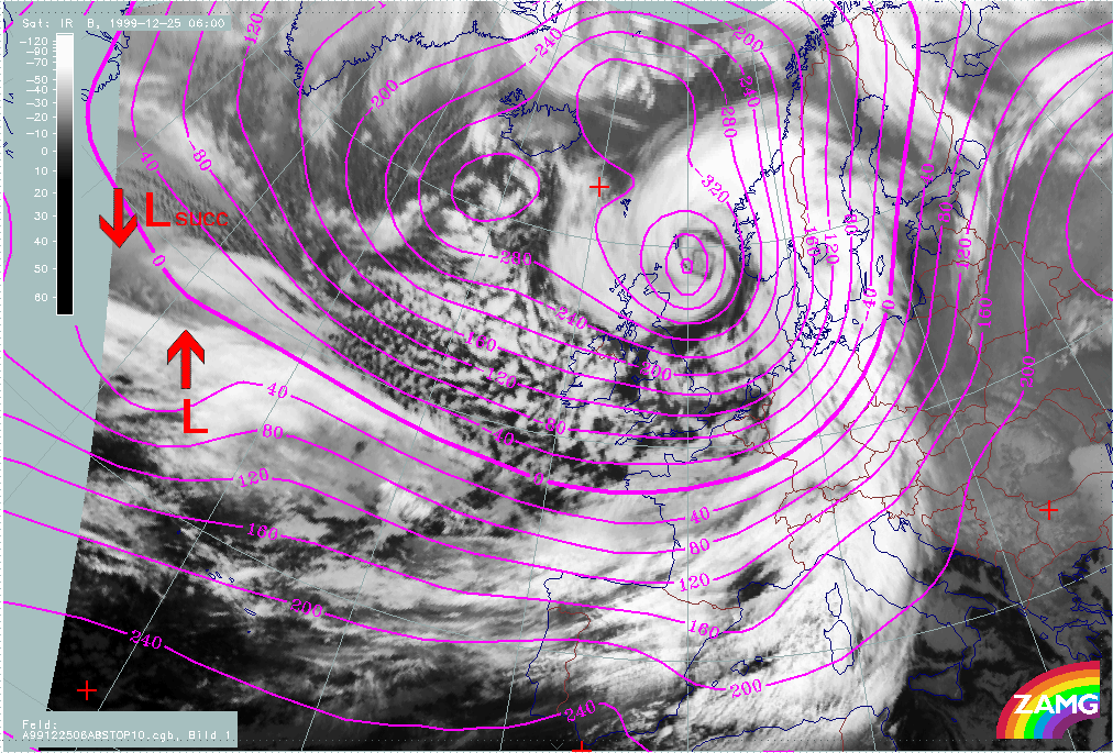
The following remarks can be summarised:
- There is a surface minimum throughout the whole phase associated with the frontal cloud band, however, during the whole period there is no low centre with closed isolines shown in the model analyses.
- For Lothar, there is a remarkable deepening of the surface minimum, from values of 0 - 40 gpm to values of (-180 gpm), between 25/06.00 and 26/06.00 UTC;
- Relationship between the surface minimum and cloud features:
- Period 25/06.00 - 12.00 UTC
The surface depression is associated with the cloud dissipation area within the zonal frontal cloud band; there is not yet any relationship with the cloud head; - Period 25/18.00 - 26/00.00 UTC:
The location of the surface depression is shifted northward to the transition area between the cloud head and the higher cloud within the zonal frontal cloud band; - Period 26/06.00 - 12.00 UTC:
The surface depression is clearly associated with the area of "Rapid Cyclogenesis".
- Period 25/06.00 - 12.00 UTC
- The cloud features of "Lothar successor" are associated with a surface trough with rather weak curvature; there is no intensification of this trough during this phase.
The field of TA is another parameter which can be used to indicate Wave development. For well developed Waves there is usually a juxtaposition of a WA maximum within the cloud bulge and a CA maximum in the cold air immediately behind the Wave. The zero line of TA crosses the Wave and surface low.
|
25 December 1999/06.00 UTC - Meteosat IR image; red: temperature advection - WA 700 hPa, blue: temperature advection - CA 700 hPa; 25/06.00 - 26/12.00 UTC 6-hourly image loop
|
|
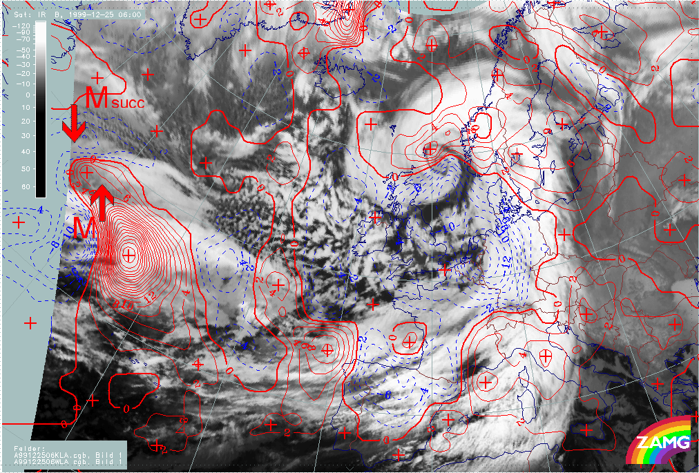
The following remarks can be summarised:
- There are very strong CA-WA maxima within the region of "Rapid Cyclogenesis" during the whole process;
- The maximum of CA coincides very well with the area of cloud dissipation in the frontal cloud band; in this region another CM, the "Front Decay" could be valid, for which meso scale CA is a indicative factor;
- The WA maximum is close to the Warm Front cloud shield but the coincidence of both is not perfect in the early phases of the storm;
- The cloud head area in the early phases is under the influence of CA; only during the later phases can WA be associated with some parts of the cloud head. However, the western part of cloud head is under CA during the whole phase; this deviates somewhat from the ideal concept of "Rapid Cyclogenesis".
- In the active period of "Rapid Cyclogenesis", the spiral centre is in accordance with the zero line of TA.
- For "Lothar successor" there is a distinct juxtaposition of small to meso scale WA and CA maxima during the whole phase; but, as for Lothar, the WA is superimposed on the frontal cloud band and only partially on the cloud head of "Lothar successor"
- A dramatic increase in the intensity of the WA maximum takes place on 26 December between 09.00 an 12.00 UTC; this is coincident with the phase where there is the appearance of the Dark Stripe in WV imagery, indicating the immediate start of Rapid Cyclogenesis.
Both parameters (height of 1000 hPa and the TA at 700 hPa) indicate the existence of intensive Wave development for Lothar. For Lothar successor the situation is basically similar as there is a surface trough and WA/CA maxima, however, there is no deepening of the surface height field. There is, currently, no explanation for this.
Martin
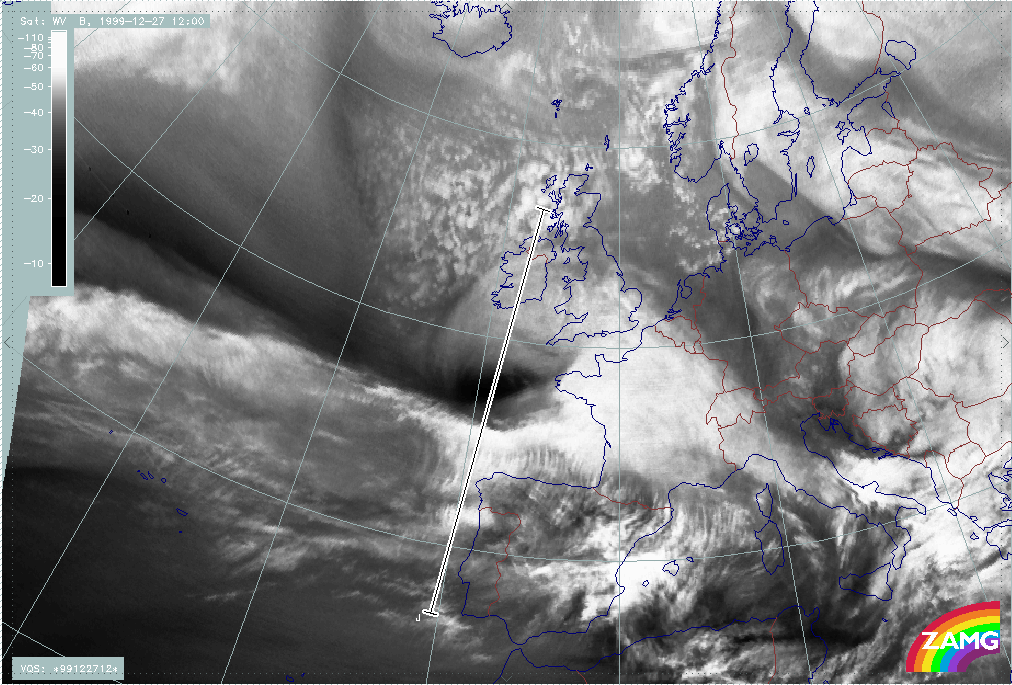
The loop showing changes in surface height at 1000 hPa from 26 December/12.00 UTC to 27 December/18.00 UTC shows several interesting features: the deepening of the surface low corresponding to Martin, and its associated cloud features.
|
26 December 1999/12.00 UTC - Meteosat IR image; magenta: height contours 1000 hPa; 25/06.00 - 26/12.00 UTC 6-hourly image loop
|
|
The following remarks can be summarised:
- There is a well marked surface low during the whole period which becomes intense in the later phases of the storm; a closed low centre appears in the isolines during the Rapid Cyclogenesis (not seen with Lothar).
- A deepening of the surface minimum from values of 40 - 80 gpm to (-200 gpm) takes place between 26/12.00 UTC and 27/18.00 UTC;
- Unlike Lothar, the low centre comprises the low cloud head and the zonal frontal cloud band during the whole period.
- The surface low of Lothar successor (seen in the eastern parts of the image) only becomes more intense in the later phases of the storm, where a merging of different cloud systems takes place.
|
26 December 1999/12.00 UTC - Meteosat IR image; red: temperature advection - WA 700 hPa, blue: temperature advection - CA 700 hPa; 25/06.00 - 26/12.00 UTC 6-hourly image loop
|
|
The following remarks can be summarised:
- As for Lothar and Martin, very strong CA-WA maxima can be detected near the region of "Rapid Cyclogenesis";
- Although the CA maxima are very intense even for Martin, there is, no notable dissipation of frontal cloud;
- The WA maximum corresponds to the Warm Front Shield; compared to Lothar, the cloud head area is much more under the influence of WA; the splitting Comma feature lies within CA; during the rapid development of the cloud head, its western part is again under the influence of WA;
- As for Lothar, the distribution of TA in the Martin case deviates from the ideal Wave configuration of the TA field;
- In the rapid development period, the spiral centre is close to the zero line of TA.
- During the further development of Lothar successor, the CA region broadens and increasingly contains the cloud spiral.
For Lothar and Martin, both parameters (the height of 1000 hPa and the distribution of TA) fulfill one pre-condition of "Rapid Cyclogenesis" and indicate a Wave feature in the appropriate area.
Upper level jet streak and left exit region
A "Rapid Cyclogenesis" is a rapidly deepening storm which can be enlightened from different points of view. In this chapter, the relationship between the upper level jet and its left exit region with "Rapid Cyclogenesis" is studied. All numerical parameter fields are computed from NWP analysis fields.
There is a very distinct connection of "Rapid Cyclogenesis" cases with the corresponding jet streak at, e.g., 300 hPa. This connection shall be be considered from two points of view:
- There are two areas within a jet streak were Wave development is likely: the right entrance region, where developments are usually rather slow, and the left exit region where developments are often extremely rapid. Reasons for the possible developments in these two areas are cross circulation cells with PVA at high levels and frontogenetic effects in lower and middle levels. PVA at higher levels (an increase of PVA with height) contributes to upward motion and is associated with convergence at middle levels and divergence at higher levels. (compare Conceptual Models: Front Intensification by Jet Crossing ).
- If "Rapid Cyclogenesis" has taken place, it can only be in the left exit region. Either a pre-existing surface minimum (Wave) is already located there or moves from the anticyclonic to the cyclonic side of the jet into the relevant region. Such a process can be seen several times during the storms of Christmas 1999.
Lothar and Lothar successor
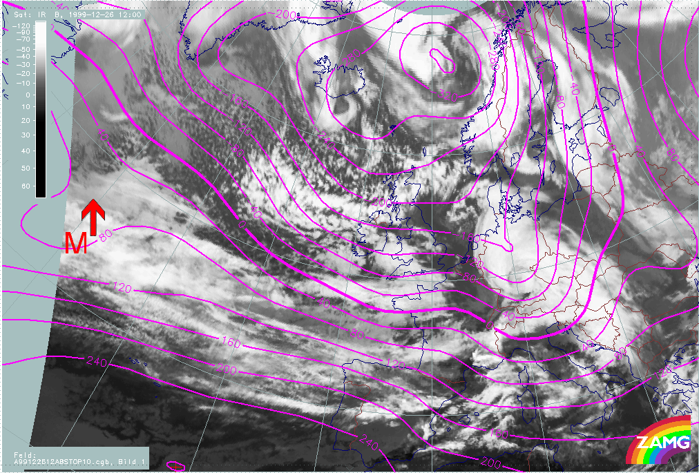
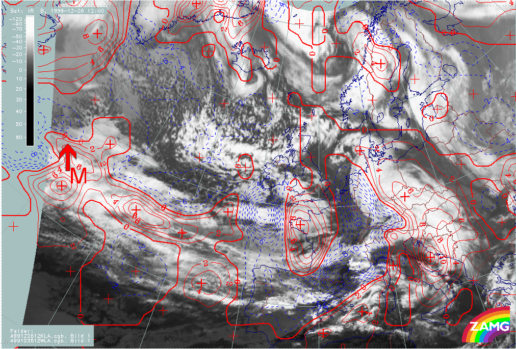
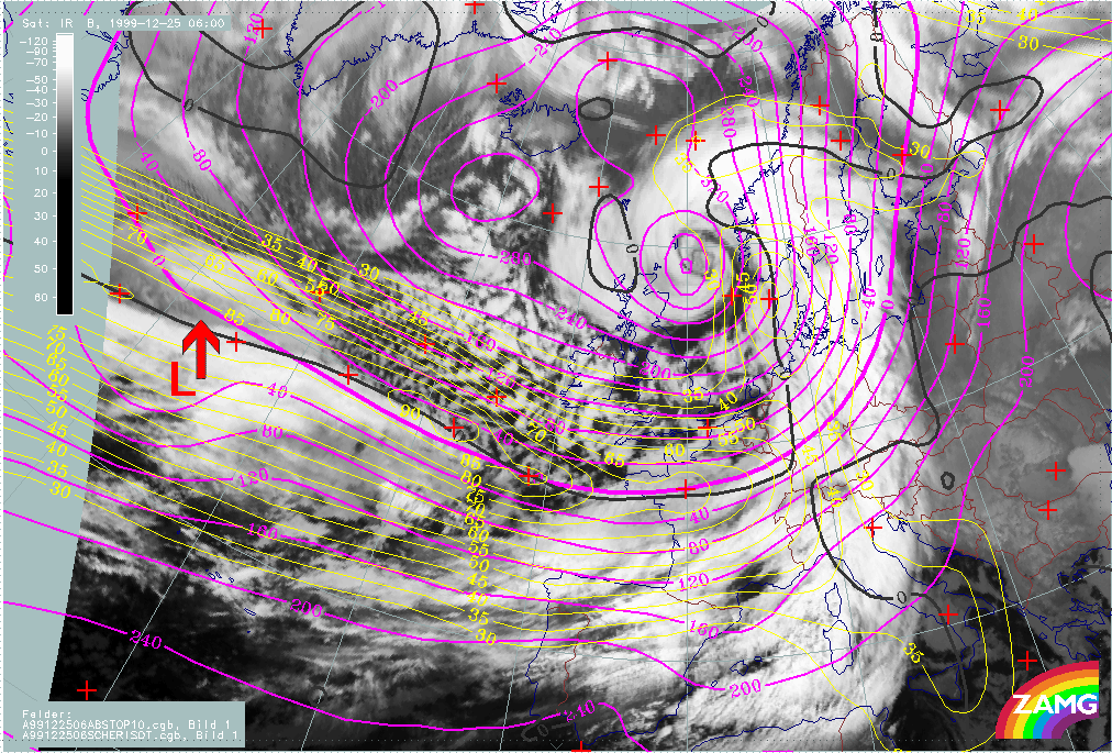
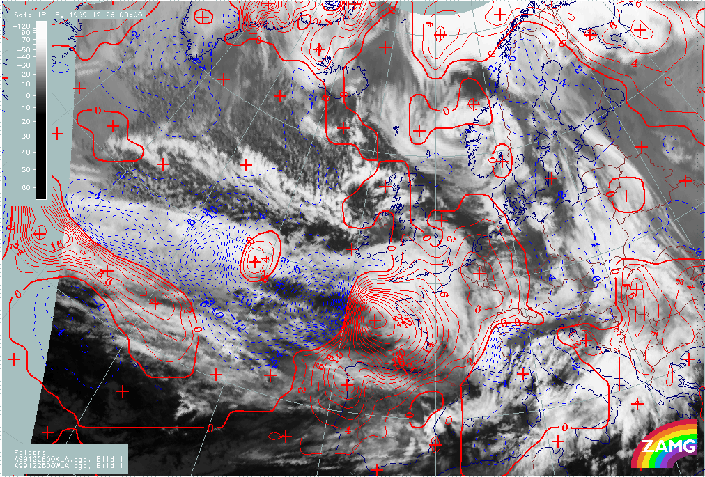
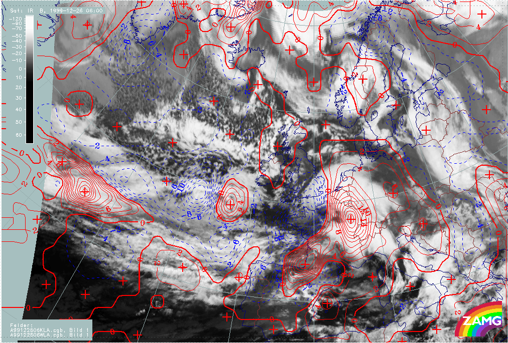
The loop below shows isotachs and PVA at 300 hPa. The combinations of these parameters allows a judgement of the "strength" of the exit region, especially the left exit region, and the relationship between typical cloud configurations and the exit region.
|
25 December 1999/06.00 UTC - Meteosat IR image; yellow: isotachs 300 hPa, black: positive vorticity advection (PVA) 300 hPa; 25/06.00 - 26/12.00 UTC 6-hourly image loop
|
|
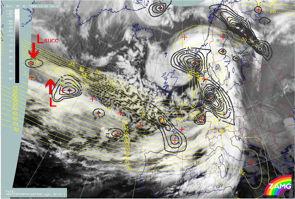
- At the start of this phase (25/06.00 UTC) there is a distinct PVA maximum associated with the "low" cloud head area but this PVA maximum is located within the jet axis. As the jet streak is rather elongated with several maxima, the location of a true exit region is not so clear.
- From 25/12.00 UTC the PVA maximum is clearly associated with a left exit region; both are close to the cloud head area: before rapid development, to the low cloud head area and, after rapid development, to the bright (high) cloud head area.
- Between 25/18.00 UTC and 26/00.00 UTC there is a dramatic intensification of the PVA maximum; this is immediately before the phase of rapid development.
- Consequently, there is a very distinct and clear relationship between "Rapid Cyclogenesis" and a maximum of PVA in the left exit region of a jet streak.
- Similar conclusions can be drawn for Lothar successor: From 26/00.00 UTC, a PVA maximum centred on the jet core is superimposed on the low cloud head; only 12 hours later does a clearer relationship appear between cloud head, PVA maximum and left exit region.
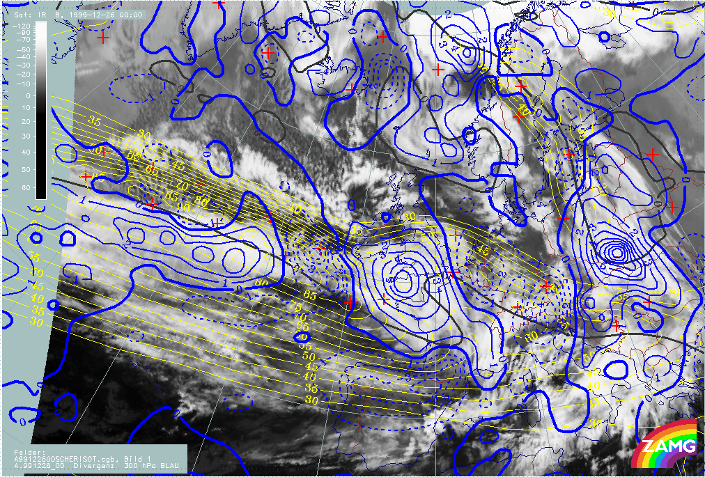
For 26/00.00 UTC the cross circulation cell in the exit region of the jet seems to be very well developed. This can be shown by studying divergence fields at 700 and 500 hPa. As shown below there is an extended area of convergence at 700 hPa in the left exit region of the jet streak which corresponds to the Rapid Cyclogenesis cloud head. In the same area there is divergence at 300 hPa. These are ideal conditions for development.
For Lothar successor there is no such relationship at this stage.
|
26 December 1999/00.00 UTC - Meteosat IR image; yellow: isotachs 300 hPa, black: shear vorticity 300 hPa, red dashed: divergence 700 hPa, red solid: convergence 700 hPa
|
26 December 1999/00.00 UTC - Meteosat IR image; yellow: isotachs 300 hPa, black: shear vorticity 300 hPa, blue dashed: divergence 300 hPa, blue solid: convergence 300 hPa
|

|
|
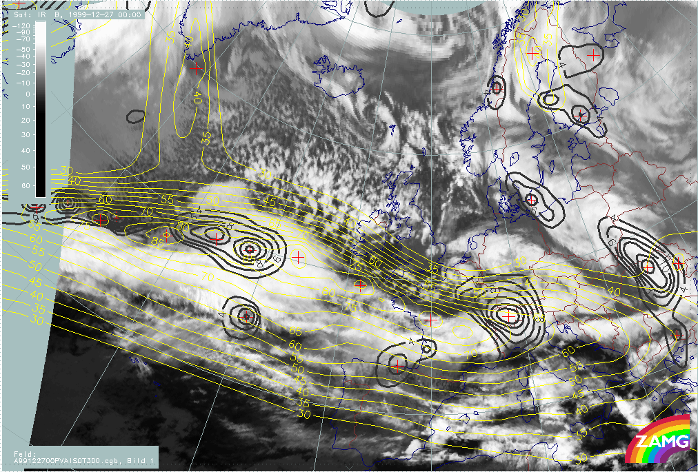
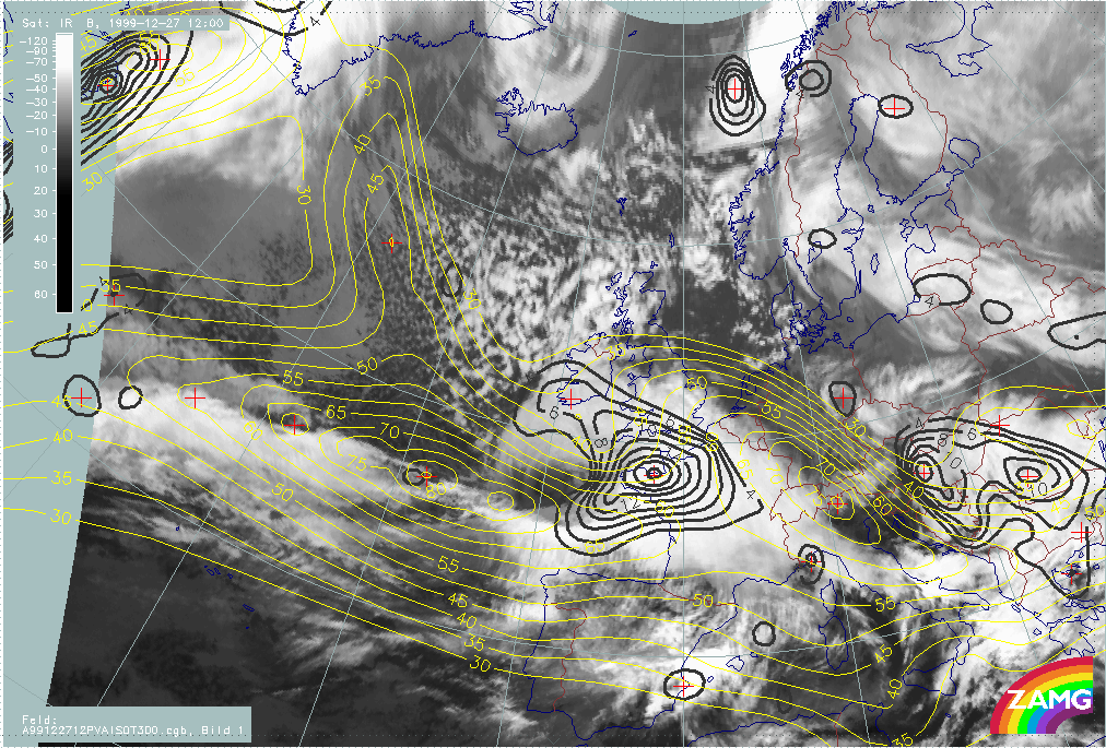
Martin
The loop below shows the isotachs and PVA at 300 hPa. The combination of these parameters allows one to judge the strength of the exit regions, especially the left exit region, and the relationship between typical cloud configurations and the exit region.
|
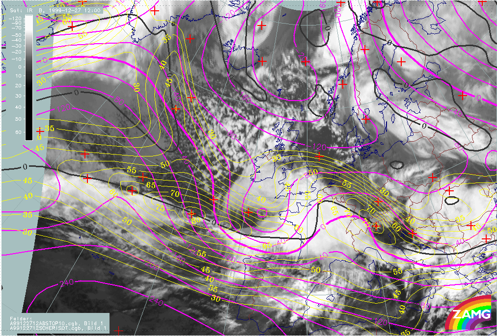
26 December 1999/12.00 UTC - Meteosat IR image; yellow: isotachs 300 hPa, black: positive vorticity advection (PVA) 300 hPa; 26/12.00 - 27/18.00 UTC 6-hourly image loop
|
|
The following remarks can be summarised:
- An intensive PVA maximum at 300 hPa is associated with the low cloud head area during this phase but the relationship with an exit region is, initially, not clear.
- Between 26/18.00 UTC and 27/00.00 UTC a small scale jet streak maximum within the rather elongated jet streak intensifies to the rear of the cloud head; a new PVA maximum develops in the left exit region and becomes associated with the low cloud head feature.
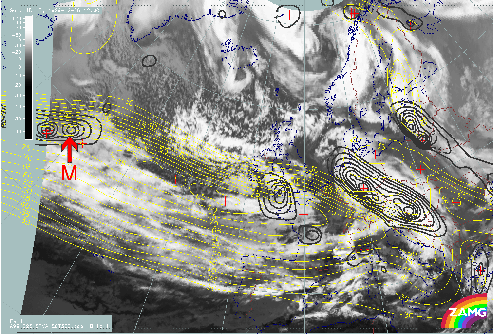
- This development continues and becomes very distinct at 27/06.00 UTC, when a remarkable intensification of the PVA maximum has taken place. This is the phase where rapid system development starts. The PVA maximum is associated with the left exit region of the intensified jet streak as well as the bright cloud head area.
- For a while, Lothar successor also showed this relationship between PVA max and the left exit region of a jet streak; but the relationship tended to disappear in time.
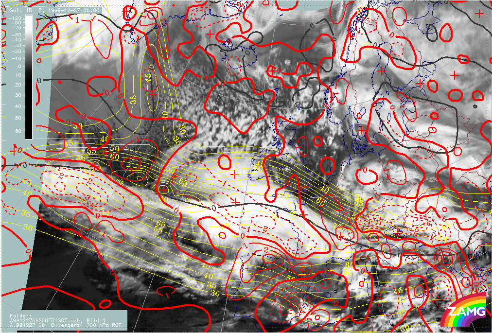
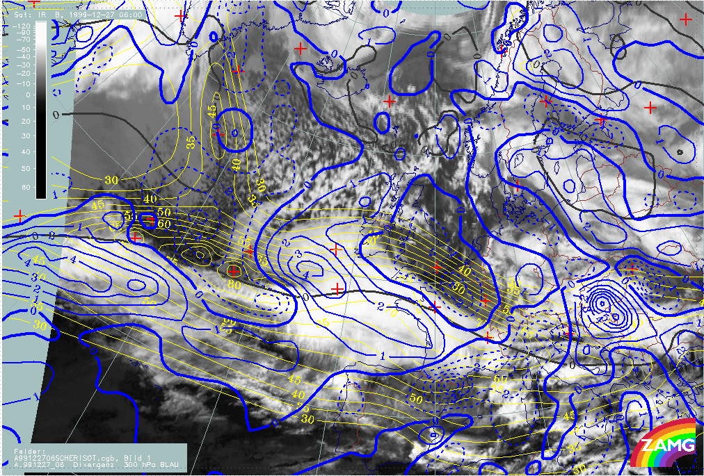
At 27/06.00 UTC, a point in time where the cloud structures of "Rapid Cyclogenesis" are already very distinct, the cross circulation cell in the exit region of the jet seems to be very well developed. This can be seen in divergence fields at 700 and 500 hPa. As shown below, there is an extended area of convergence at 700 hPa in the left exit region of the jet streak, which corresponds to the cloud head. In the same area, there is divergence at 300 hPa. When comparing with Lothar, the vertical distribution of convergence and divergence in the left exit region reflects the classical ideas for both storms, but the situation in the right exit region is much more ideal for Lothar.
|
27 December 1999/06.00 - Meteosat IR image; yellow: isotachs 300 hPa, black: shear vorticity 300 hPa, red dashed: divergence 700 hPa, red solid: convergence 700 hPa
|
27 December 1999/06.00 - Meteosat IR image; yellow: isotachs 300 hPa, black: shear vorticity 300 hPa, blue dashed: divergence 300 hPa, blue solid: convergence 300 hPa
|
|
|
Relation between upper level jet streak and surface wave
The relationship between the development of surface wave features and upper level flow in the Christmas storms is studied below. All numerical parameter fields are computed from NWP analysis fields.
Lothar and Lothar successor
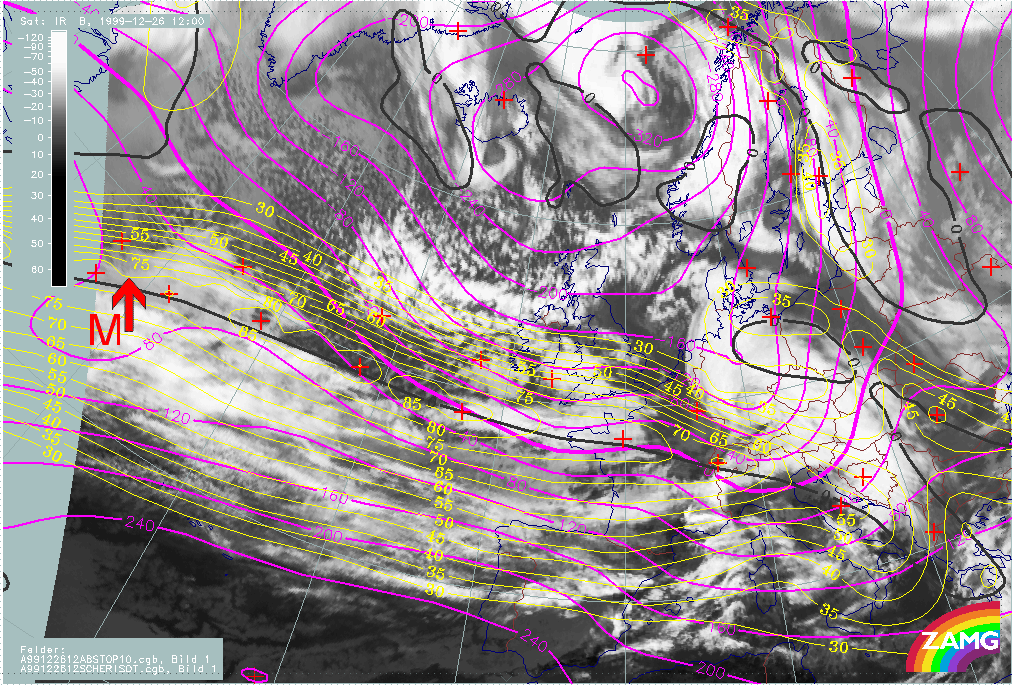
The loop below contains the height contours at 1000 hPa (for the surface features) and isotachs at 300 hPa (for the jet features).
|
25 December 1999/06.00 UTC - Meteosat IR image; yellow: isotachs 300 hPa, black: shear vorticity 300 hPa, magenta: height contours 1000 hPa; 25/06.00 - 26/12.00 UTC 6-hourly image loop
|
|
The following remarks can be summarised:
- At 25/06.00 UTC, the surface low is on the anticyclonic side of the jet and close to the jet core; at this stage there is no clear relationship with the exit region;
- In the phase from 25/12.00 - 18.00 UTC the surface low is still on the anticyclonic side of the jet but much nearer to the exit region; as the right exit region is not an area for cyclonic development, the low cloud head exist but without any rapid development; however, at 18.00 UTC the surface low is already very close to the jet axis.
- From 26/00.00 UTC, the surface depression has moved into the left exit region and "Rapid Cyclogensis" begins.
- For Lothar successor the surface low moves during the whole period from the anticylonic side to the cyclonic side of the jet. Only from 26 December/12.00 UTC does the relationship with an exit region becomes more distinct. This is also the point in time where some signs of a Rapid Cyclogenesis (e.g. darkening in the WV imagery) occur. Until this time the rather weak features in the surface trough and the poor relationship with an exit region can be reasons for the lack of a rapid development.
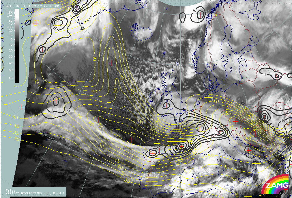
Martin
The loop below contains the height contours at 1000 hPa (for the surface features) and isotachs at 300 hPa (for the jet features).
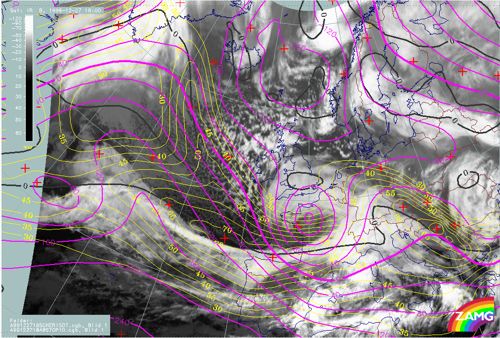
|
26 December 1999/12.00 UTC - Meteosat IR image; yellow: isotachs 300 hPa, black: shear vorticity 300 hPa, magenta: height contours 1000 hPa; 26/12.00 - 27/18.00 UTC 6-hourly image loop
|
|
The following remarks can be summarised:
- At 26/12.00 UTC the surface low is located on the anticyclonic side of the jet; because the jet is elongated there is no clear relationship with the exit region;
- During the next 12 hours, till 27/00.00 UTC, there is a strengthening of the jet streak, and a development of two smaller scale velocity maxima in and immediately behind the area of the "low" cloud head;
- During this phase the surface low moves from the anticyclonic to the cyclonic side of the jet. It is still difficult to visually determine an exit region;
- During the phase 27/00.00 UTC - 12.00 UTC, there are very distinct image features showing Rapid Cyclogenesis, and a further increase of the jet streak; there is now a clear relationship between the surface low, the left exit region and the "Rapid Cyclogenesis" area.
- Therefore (also for Martin) a movement of surface depression from the anticyclonic side into the left exit region can be seen; the fast development only starting after the surface depression has reached the left exit region. In case of Martin the intensification of the jet streak is an important feature for rapid development.
The role of Potential Vorticity (PV)
A "Rapid Cyclogenesis" is a rapidly deepening storm which can be enlightened from different points of view. In this chapter, the relationship between "Rapid Cyclogenesis" and upper and low level PV is studied. All numerical parameter fields are computed from NWP analysis fields.
Two different views on the role of PV are included in this chapter, namely:
- The downward protrusion of stratospheric air (PV values > 2 units)
- The influence of sinking upper level PV maxima upon a tropospheric baroclinic zone.
According to theory, PV anomalies develop where dry stratospheric air descends into the troposphere on an isentropic surface. PV values below 1 unit can be regarded as tropospheric air while PV values higher than 2 units are characteristic of stratospheric air; it is also known that the limits of 1 and 2 PV units should not be regarded too strictly. Processes such as tropopause folding or cut off upper level lows, could lead to PV anomalies (containing stratospheric air) at lower levels.
Another view considers the interaction of higher and lower layers. If a sinking PV anomaly approaches a baroclinic zone, cyclogenesis can be released or strengthened by the upper air phenomenon. In this theory, stratospheric air need not necessarily protrude downward into low layers, but it enhances the circulation and cyclogenesis there.
There is a very good relationship between these PV considerations and the jet streak consideration, because there is downward penetration of PV along the cyclonic side of a jet streak, resulting in Dark Stripes in WV imagery.
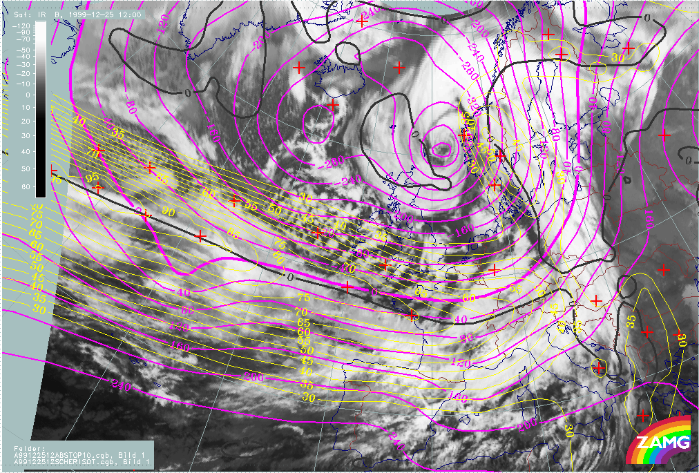
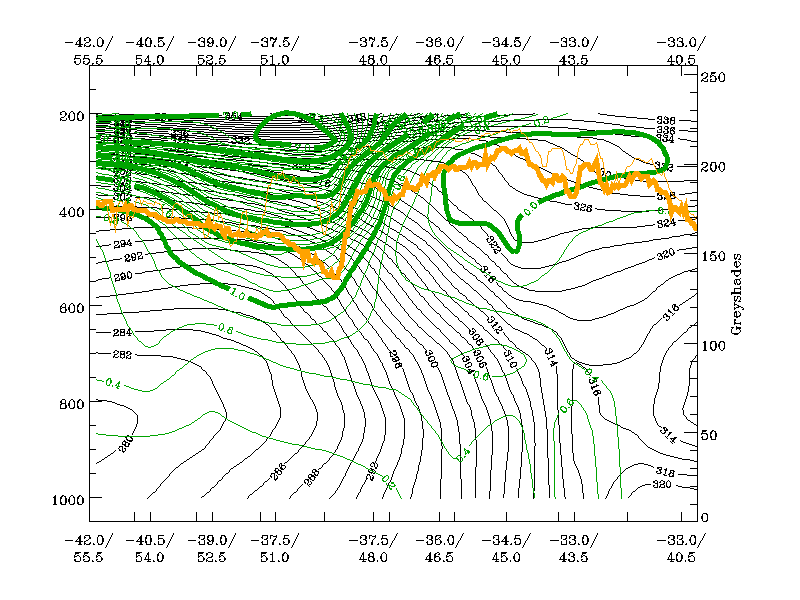
Lothar
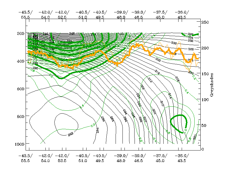
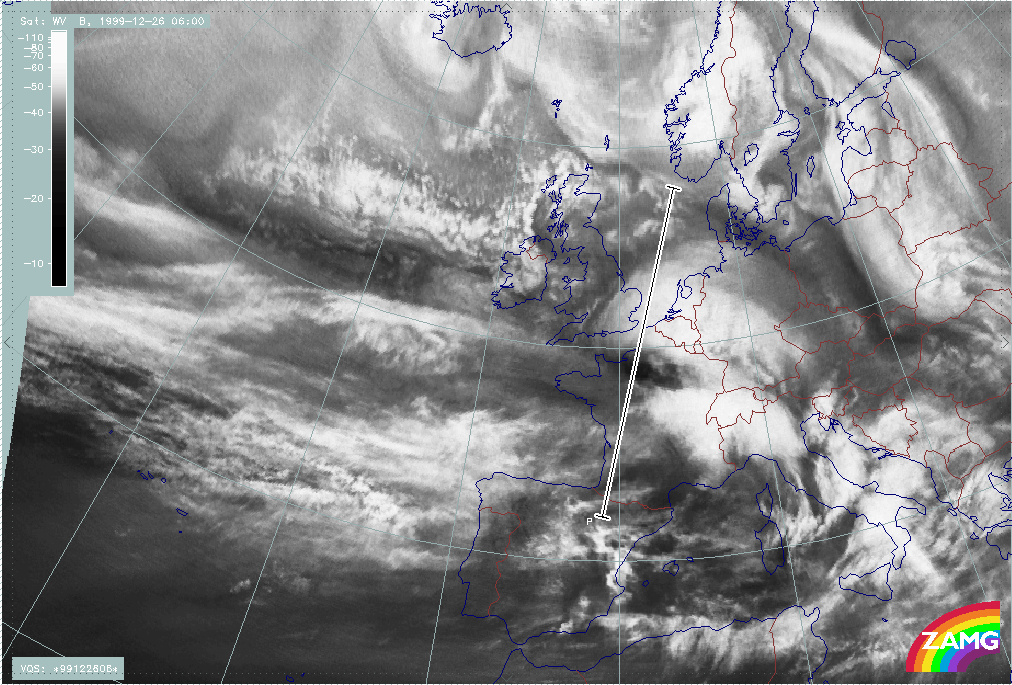
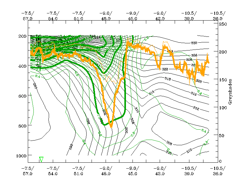
The loop below shows vertical cross sections superimposed on WV images. The cross sections have been chosen so that they cross the area immediately to the rear of the cloud head and the darkest area of the WV stripe.
|
25 December 1999/06.00 UTC - Meteosat WV image; position of vertical cross section indicated; 25/06.00 - 26/06.00 UTC 6-hourly image loop
|
|
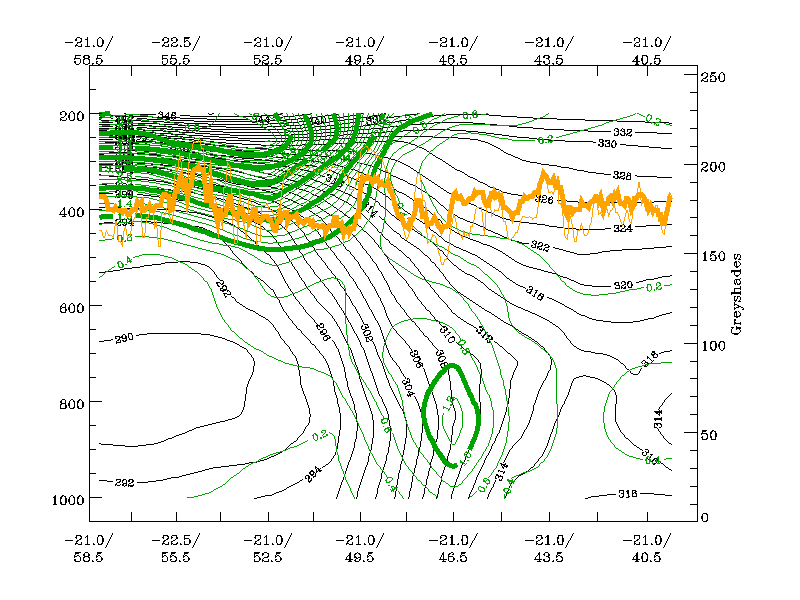
The loop below shows the corresponding vertical cross sections containing isentropes and PV.
|
25 December 1999/06.00 UTC - Vertical cross section; green: potential vorticity, orange thin: IR pixel values, orange thick: WV pixel values; 25/06.00 - 26/06.00 UTC 6-hourly image loop
|
|

The following remarks can be summarised:
- If the PV = 2 value is regarded as the boundary between stratospheric and tropopsheric air, then this dry air mass protrudes down to about 400 - 450 hPa;
- Since this can be regarded as tropopause height, the values indicate a rather low tropopause;
- But: there is, subsequently, no further downward protrusion with this line of 2 PV units;
- Instead, the lowest height of the PV = 2 units approaches the frontal zone and, in parallel, low level PV (and airmass rotation) intensifies.
- The frontal zone (characterised by isentropes) is rather broad and during the approach of a PV anomaly, an intensification of low level PV occurs, especially in the northern part which happens to be closer to the approaching upper level PV maximum.
- Finally, the two PV maxima merge and are enclosed by the PV = 1 unit line.
The development of Lothar, therefore, seems to have been assisted by the interaction of an upper level PV maximum and a low level baroclinic zone.
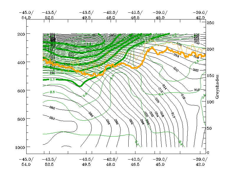
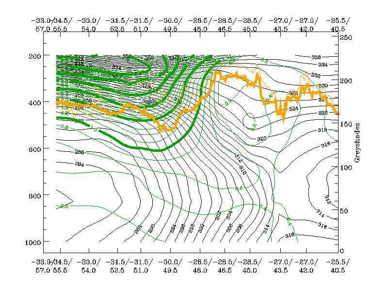
Lothar successor
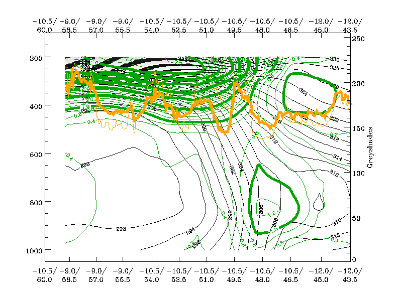
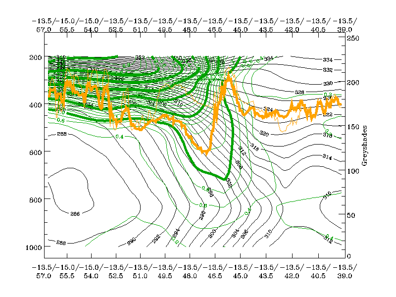
The loop below shows vertical cross sections superimposed on WV images. The cross sections have been chosen so that they cross the area immediately to the rear of the cloud head and the darkest area of the WV stripe.
|
25 December 1999/06.00 UTC - Meteosat WV image; position of vertical cross section indicated; 25/06.00 - 26/12.00 UTC 6-hourly image loop
|
|

The loop below shows the corresponding vertical cross sections containing isentropes and PV.
|
25 December 1999/06.00 UTC - Vertical cross section; green: potential vorticity, orange thin: IR pixel values, orange thick: WV pixel values; 25/06.00 - 26/12.00 UTC 6-hourly image loop
|
|
The following remarks can be summarised:
- As in the two other storm cases, there is a upper level PV maximum protruding downward to around 450 - 500 hPa until 26 December/00.00 UTC; the effect of downward protrusion is even more pronounced in the PV = 1 line;
- As in the other two cases, there is a very broad baroclinic zone
- As in the other two cases, there is an intensification of PV in the northernmost part of the baroclinic zone
- In contrast to the other two cases, the PV = 1-2 maxima ascends rather than descending further in the phase where rapid development could be considered possible.
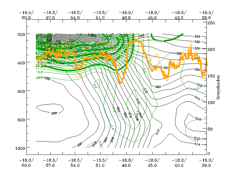
Martin
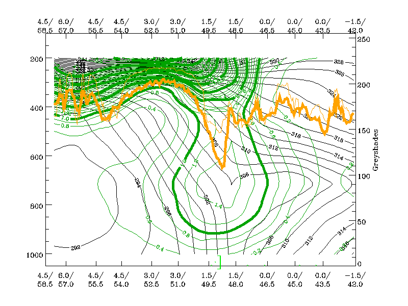
The loop below shows vertical cross sections superimposed on WV images. The cross sections have been chosen such that they cross the area immediately to the rear of the cloud head and the darkest area of the WV stripe. Only when rapid development takes place, the vertical cross section shifts somewhat into the region of the cloud head. Therefore a large change in the distribution of PV has to be considered and thus two vertical cross sections are computed and compared.
|
26 December 1999/12.00 UTC - Meteosat WV image; position of vertical cross section indicated; 26/12.00 - 27/12.00 UTC 6-hourly image loop
|
|

The loop below shows the corresponding vertical cross sections containing isentropes and PV.
|
26 December 1999/12.00 UTC - Vertical cross section; green: potenial vorticity, orange thin: IR pixel values, orange thick: WV pixel values; 26/12.00 - 27/12.00 UTC 6-hourly image loop
|
|
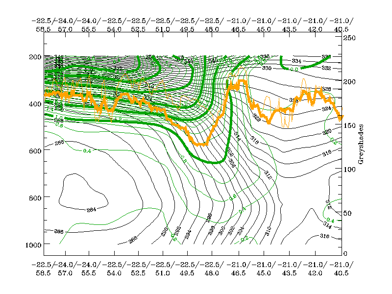
The following remarks can be summarised:
- The vertical cross section of PV, which is located immediately behind the cloud head in the whole phase, shows that the PV=2 unit line descends to about 500 hPa, representing a rather low tropopause height,
- The PV = 1 unit line protrudes rapidly downward as far as 800 hPa;
- Low level PV in the baroclinic zone, which is extremely broad, is not as distinct as it was the case for Lothar;
- But, as for Lothar, there is an increase in low level PV during the approach of the PV 2 unit line;
- In contrast to Lothar, where the low level PV was much more intensive (a column of PV values > 1 unit developed throughout the whole troposphere). In this case, the downward protrusion of the 1 - 2 units line and the corresponding air mass seems to be the dominant feature.
Weather
Lothar and Lothar successor
|
Image of the barograph from Paris Charles de Gaulle airport 25 - 27 December 1999
|
|

|
Lothar was characterised by its small scale, its rapid development and its high wind speeds.
The drop in surface pressure was dramatic (see diagram above), falls of more than 10 hPa/hour were measured over NW France and the rise in pressure immediately following the passage of the low
was approximately the same.
The storm track followed a semicircle and was about 200 km wide. It started over the English channel and moved over the Paris area towards Alsace, the German Black Forest and northern
Switzerland, losing its strength over Austria and the Czech Republic.
Within this 200-km wide track over France, Germany and the northern part of Switzerland, 10-min. averages of max wind greater than 50 kt (10 Bft) were measured. Wind gusts varied between 80 and
100 kt with a maximum of 117 kt at Pontorson (South Normandy).
In the storm frontal zone, moderate rain was reported. Further to the east, heavy snowstorms and blizzards over higher grounds were reported.
After 25 December 06.00 UTC, a squall line developed south of Paris, and moved towards Switzerland, with heavy showers, hail and thunder.
Martin
Storm Martin was much larger than Lothar and the area in which the 10-min average max. wind exceeded 50 kt was approximately 500 km wide over the southern and western parts of the storm.
Highest winds were reported over the coastal areas of southern Brittany, and the Bordeaux area, towards northern Spain, between 12.00 and 21.00 UTC. The fall and rise in surface pressure before
and after passage of the centre were, as with Lothar, also close to a 10 hPa/hour. Windgusts in the above mentioned area were mostly between 70 and 90 kt with a maximum of 107 kt over the
Island of Oleron.
During passage of the frontal systems, moderate to heavy rain was reported with heavy snow on higher ground. In the colder airmass behind the Cold Front, showers occurred, some with thunder.
Economic Damage
The death toll of Lothar and Martin was over 150 victims of which nearly 90 were in France.
Structural damage was wide-spread over Europe and was reported from France (most damage), Great Britain, Germany, Belgium, Luxembourg, Spain, Switzerland, Austria, Italy, the Czech Republic and
Poland.
Transport in some of these countries was disrupted for several days.
In France 2.5 million households were without electricity and after a week, half a million households still had no electricity. 4% of the forests were destroyed, representing more than 90
million cubic meters of timber.
Structural property damage was enormous: In France one out of twelve schools were damaged and the damage caused to historic monuments exceeded 120 million Euros.
The total cost of damage caused by the two storms is difficult to calculate but it will certainly exceed 6 billion Euros.
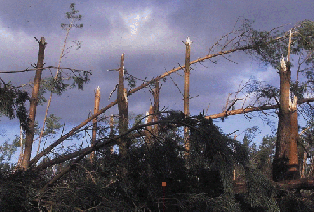
|
The remains of a forest on the Isle of Oleron (France) after Martin
|
|
|
Numerical Model forecast problems
Behaviour of the ECMWF model
The storm of the 26th (Lothar) only appeared in the 18 hour forecast from 12.00 UTC on the 25th and not at all in preceding forecasts (except D 71/2). Analysis of the storm was also difficult; the 9 and 6-hour forecasts were better for intensity rather than analysis. For the 27th (Martin) there was really nothing in the short range forecasts, even though it had been present in the D+6, 7 and 8 forecasts. The large-scale development was well predicted, associated with a strengthening of the sub-tropical high and the establishment of a straight and very strong jet. The track of the second cyclone could be followed in data assimilation over the Atlantic, but was lost during the 26th. There were data, particularly one SHIP, which were not used correctly and flagged. The main point is that these developments were, in principle, predictable since medium range forecasts showed correct developments. It was more a problem of data assimilation and the mis-use of data by the models somehow caused the cyclones to be lost.
Behaviour of the HIRLAM model
The KNMI Hirlam model performed badly in both cases. Although, for the forecast period less than 18 hours ahead, Hirlam did forecast the position of Lothar reasonably well, its development was
greatly underestimated even in the nowcast period of less than 6 hours ahead. The analyses were not correct and resulted in an underestimation of central surface pressure.
This makes a more thorough quantitative investigation difficult because of the absence of reliable data.
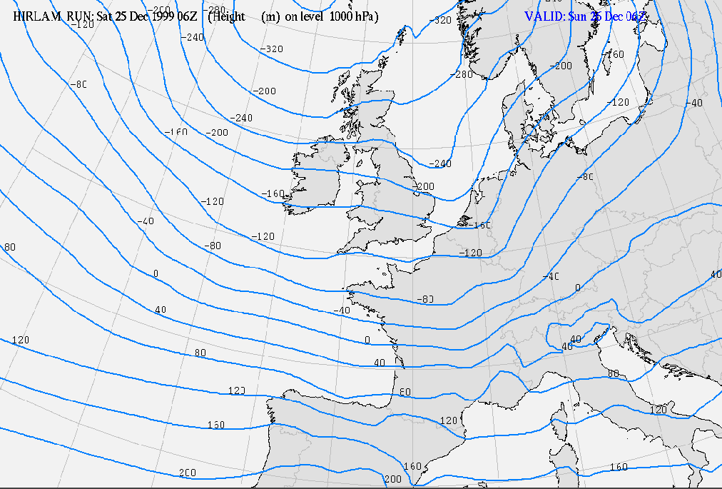
The +24 hours forecast from the Hirlam model run from Christmas day 25 December 1999/06.00 UTC showed only a weak trough in the 1000 hPa height field at the position of Lothar (see left chart
below). A deeper trough is calculated over the Netherlands. By 26 December at 06.00 UTC, a deep low with its centre SW of Paris was a dominant feature, but there was no trough over the Low
Countries (see right chart below) This was a result of severely underestimated development of Lothar (in terms of warm advection in front of the low).
|
25 December 1999/06.00 UTC - HIRLAM/KNMI +24 hours forecast height 1000 hPa
|
26 December 1999/06.00 UTC - HIRLAM/KNMI Analysis height 1000 hPa |
|

|
In the case of Martin the poor performance of the models was even more striking. KNMI Hirlam was no exception.
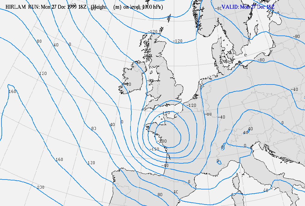
The +24 forecast of the 1000 hPa height field from the run of 26 December 1999 18.00 UTC only shows a very weak and flat trough near the mouth of the river Loire, the position of Martin at that
time (see left chart below). In reality Martin was a very deep and extensive low with a much larger radius than Lothar. (see right chart below).
|
26 December 1999/18.00 UTC - HIRLAM/KNMI +24 hours forecast height 1000 hPa
|
27 December 1999/18.00 UTC - HIRLAM/KNMI Analysis height 1000 hPa |

|
|
Other models
Other NWP models across Europe also failed to predict the severity of the storms, although the French ARPEGE model and its high resolution sub-model ALADIN provided reasonable guidance for
Lothar.
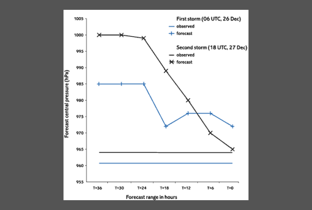
Most models were generally very poor in the forecast a day before the storms but improved with shorter lead times (see the illustration below from the behaviour of the UK model).
|
Forecast and observed mslp for the storm centres at the peak of each storm (UK Met.Off.)
|
|
|
High-resolution models did not give significantly better results.
Even scattero-meter wind data and data from ATOVS (Advanced Tiros Operational Vertical Sounder) used in reruns of some models resulted in little improvement in forecasts.
Satellite Reports (SatRep) were not produced during the two Christmas holidays but on the 27/06.00 UTC the SatRep (made by ZAMG) indentified Martin as the Conceptual Model: Rapid Cyclogenesis
(RaCy) with the following text:
"16. Rapid Cyclogenesis: Atlantic 4918W analysis from the satellite loop cloud head in weak CA !! (-2K/12 hours)." This indicates that this rapid development was detected using
satellite data only and that the models did not support this diagnosis. In the 27/12.00 UTC SatRep, produced by KNMI, the text was similar for this RaCy.
The obvious discrepancy between model forecast and SatRep analysis certainly increased the attentiveness of the forecaster to this problem and made her/him aware that he has to question the
model forecasts (in this case both ECMWF and HIRLAM).
References
- ARBOGAST, P., HELLO, G. AND JOLY, A. (2000): A dynamical interpretation of the two French 1999 christmas stor; Centre National de Recherches Meteorologiques TOULOUSE
- EQE Summary Report: The European storms Lothar and Martin December 26 - 28, 1999
- EUMETNET: Report from SRNWP/EUCOS meeting, Toulouse 12 - 13 October 2000
- Kurz M.: The December storms in 1999; Deutscher Wetterdienst, Offenbach, 2000
- MAAS, A. and VAN DEN BERG, W.: Analyse van de Kerststormen; Meteorologica, jaargang 9, nr 1, march 2000.
- PEARCE R., LLOYD, D. AND MCCONNELL, D.: The post-christmas 'french'storms of 1999; Weather Vol. 56, March 2001.
- PERSON, A.: ECMWF documentation of theFrench storm, I, II and III; O/MOP/22 February - March 2000
- SAUNDERS, F.: The December 1999 European storms; NWP Gazette September 2000
- TIJM, S.: HIRLAM en de kerststormen; Meteorologica, jaargang 9, nr 1, march 2000
- ULBRICH, U., FINK, A.H. KLAWA, M. and PINTO, J.G.; Institut fuer Geophysik und Meteorologie der Unversitaet zu Koeln, Germany: Three extreme storms over Europe in December 1999; Weather Vol. 56, March 200.