Lothar and Lothar successor
Analysis of Lothar from satellite features
|
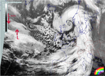
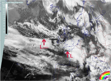
25 December 1999/06.00 UTC - Meteosat IR image; 25/06.00 - 26/00.00 UTC 3-hourly image loop
|
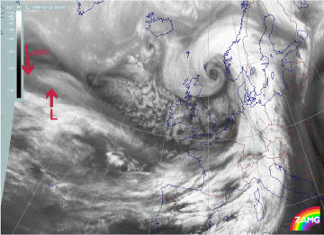
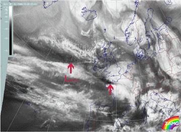
25 December 1999/06.00 UTC - Meteosat WV image; 25/06.00 - 26/00.00 UTC 3-hourly image loop
|
Summary of typical, yet important features in IR and WV imagery for the initial stage of Lothar:
- A broad zonal frontal cloud band, highly structured and composed of cloud fibres at different heights above lower denser cloud fields, extends zonally across the Atlantic;
- The Warm Front Band cloud does not differ much from the main frontal cloud band;
- A "cloud head" exists from the very beginning: this is a lower cloud part penetrating below the zonal front band in direction of the cold air (see red arrow in left hand image). This is not yet a fully developed cloud head of "Rapid Cyclogenesis" but it does indicate possible areas for a Wave and a subsequent rapid development;
- In the case of Lothar the frontal cloud decays immediately to the rear of the low cloud head and close to the rapid development (25/12.00 - 21.00 UTC);
- The WV images show a Dark Stripe at the rear of and along the broad frontal cloud; in the beginning there appears to be a double structure, the more northern black line becomes a feature associated with a subsequent development ("Lothar successor" see below).
- Such a situation can persist for some time until fast "Rapid Cyclogenesis" starts. This happened on 26 December from 00.00 UTC on.
|
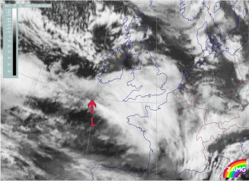
26 December 1999/00.00 UTC - Meteosat IR image; 00.00 - 06.00 UTC half-hourly image loop
|
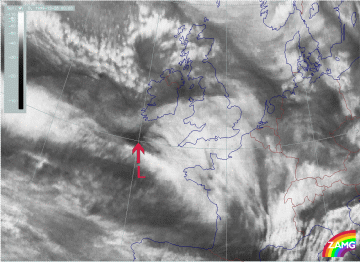
26 December 1999/00.00 UTC - Meteosat WV image; 00.00 - 06.00 UTC half-hourly image loop
|
Summary of typical and important features in IR and WV for the fast "Rapid Cyclogenesis" development of Lothar:
- A local darkening (in WV and IR) of an area to the rear of or slightly upstream from the cloud head where the development is going to take place (26/00.00 - 01.00 UTC)
- An intensive development of a Dark Stripe between the zonal cloud band and the cloud head within a very small time scale of several (about 6) hours in both: IR and WV (see region of red arrow);
- The rapid and pronounced intensification of a cloud head (already from 25/18.00 UTC on);
- A subsequent development of a pronounced cloud spiral comprising an increasing black area in the WV.
|
26 December 1999/03.00 UTC - Meteosat IR image; 03.00 - 12.00 UTC 3-hourly image loop
|
26 December 1999/03.00 UTC - Meteosat WV image; 03.00 - 12.00 UTC 3-hourly image loop
|
The further "rapid cyclogenesis" development shows:
- The rapid development of a very intensive cloud spiral
- Clouds close to the centre of the surface low (very small scale) can rotate several times around the centre, indicating very high wind speeds (similar to tropical storms);
- A Comma - like but small to mesoscale line of cells often develops in the centre of the low.
Diagnosis of "Lothar successor" from satellite features
|
25 December 1999/06.00 UTC - Meteosat IR image; 25/06.00 - 26/00.00 UTC 3-hourly image loop
|
25 December 1999/06.00 UTC - Meteosat WV image; 25/06.00 - 26/00.00 UTC 3-hourly image loop
|
Summary of typical and important features in IR and WV for the initial stage of Lothar successor:
- "Lothar successor" can be seen from the very beginning in IR images as a substructure in the western part of the low cloud head belonging to Lothar and later as separate (cut off) cold air feature (25 December/06.00 - 15.00 UTC)
- During the same period the WV image shows a pronounced Dark Stripe to the rear of the cloud structure of "Lothar successor"; this WV stripe is much more pronounced than the mere grey shade gradient to the rear of the cloud head belonging to Lothar;
- At 18.00 UTC on 25 December the start of a dramatic change in the WV image can be seen: the area behind the cloud head belonging to Lothar darkens significantly compared to the still dark area behind the cloud head belonging to "Lothar successor"; this is the first indication of the Rapid Cyclogenesis going on within Lothar (see above);
- From 18.00 UTC on 25 December a Wave feature develops in the frontal cloud band in the area of the cloud head belonging to "Lothar successor"; consequently, the bright cloud to the rear of the frontal cloud band is shifted northward and thus partly hides the lower cloud bulge.
Loop of 3-hourly images from 26 December 12.00 till 21.00 UTC shows the further development of "Lothar successor"
|
26 December 1999/03.00 UTC - Meteosat IR image; 03.00 - 12.00 UTC 3-hourly image loop
|
26 December 1999/03.00 UTC - Meteosat WV image; 03.00 - 12.00 UTC 3-hourly image loop
|
The following features can be summarised:
- Although there are some features which are indicative of rapid development, no such development takes place.
- Between 26 December 03.00 - 09.00 UTC there is a dissipation of the frontal cloud band close to the area of the cloud head of "Lothar successor" - a process which could also be observed with Lothar;
- Between 26 December 06.00 and 09.00 UTC, there is a distinct darkening in the WV image, immediately behind the cloud head belonging to "Lothar successor"; this could be regarded as the start of "Rapid Cyclogenesis";
- But: instead of a dissipation of cloudiness in the cloud head and a subsequent intensive spiral development, a rather weak spiral, typical of a Comma develops.
- This spiral increases somewhat but remains at meso-scale; there are extensive cold air features behind.
