
Weather
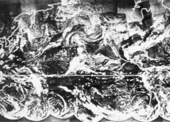
Jochen Kerkmann gives an overview on the historical development of satellites, orbits and instruments.
Length: 30 minutes.
The invention of weather satellites has opened a new area in weather forecasting. Satellite observations enable to continuously monitor the weather regimes on the whole globe. Therefore they provide a powerful tool in weather forecasting. This lecture leads from the invention of weather satellites to the current operational satellites.
Gavin Robbins presents the meteorological conditions that led to the largest coastal surge down the East Coast of England since 1953.
Length: 30 minutes.
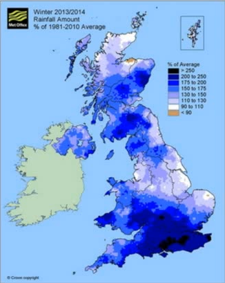
The winter of 2013-14 was the wettest for 250 years across England and Wales, with a succession of storms bringing sustained flooding from all natural sources, coastal, fluvial, surface water and groundwater. The presentation will start with an overview of the meteorological conditions that led to the largest coastal surge down the East Coast of England since 1953. The hydrometeorological conditions and flooding through late December 2013 to March 2014 will then be considered, along with examples and mechanisms of communicating the high impact conditions to emergency responders and Central Government. This included two briefings directly to our Prime Minister. Meteorological drivers and the possible teleconnections behind the exceptional conditions will also be considered.
Humberto Barbosa talks on the use of satellite precipitation products for mapping land slides in Brazil.
Length: 50 minutes.
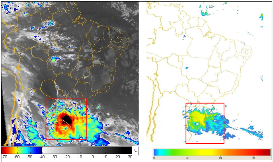
Research during the past decade has documented the importance of satellite precipitation products to the overall workings of the tropical landslide susceptibility. Several types of satellite precipitation products are used for landslide assessment but the area they see, and the frequency of observations, varies. Two complementary types are particularly relevant to landslide management. Polar-orbiting satellites fly in a relatively low orbit (often at around 1000km above the ground), providing relatively high spatial resolution. But they only collect data over the same point once every few days. Geostationary satellites are positioned at a much higher altitude (about 36,000km). They orbit the Earth at the same speed as the Earth rotates on its axis, in effect remaining stationary above the ground and viewing the whole earth disk below. Their spatial data is much coarser, but is collected at the same point every 15 minutes. Moreover, rainfall-triggered landslides tend to be local-scale features, but ground conditions are also very important. When they destroy people's lives and livelihoods, they become natural disasters. Thus, Understanding the nature of spatial and temporal variability of rainfall events in developing countries is important to improve the landslide-prediction science. This seminar will present an overview of recent landslide examples in Brazil and applications of satellite precipitation products. A key satellite input dataset for the integrated applications is the EUMETSAT’s Satellite Application Facility on Support to Operational Hydrology and Water Management.
Giulia Panegrossi presents precipitation products and applications of the Hydrology SAF.
Length: 64 minutes
Within the EUMETSAT Satellite Application Facility on support to Operational Hydrology and Water Management (H-SAF), different precipitation products have been developed. The products exploit either measurements from passive microwave (PMW) radiometers on board polar orbiting satellites, or combination of Meteosat Second Generation (MSG) IR observations with the available PMW precipitation estimates. Some of the products are currently operational (http://hsaf.meteoam.it), and are available for near-real time precipitation monitoring and hydrological applications. Others are being improved and extended to satellites that have become recently operational [i.e., the polar orbiting Core Observatory of the Global Precipitation Measurement mission, (GPM), or the NPP Advanced Technology Microwave Sounder, ATMS)] or that will be operational in the near future (i.e, Meteosat Third Generation. MTG). The H-SAF precipitation products will be presented, focusing on the strengths, weaknesses, and potentials of the current products, and future perspectives offered by the products in development will be outlined.
In this presentation some applications of H-SAF precipitation products will be shown.

Nuno Moreira reports on a flash flood event on Madeira in 2010.
Length: 36 minutes.
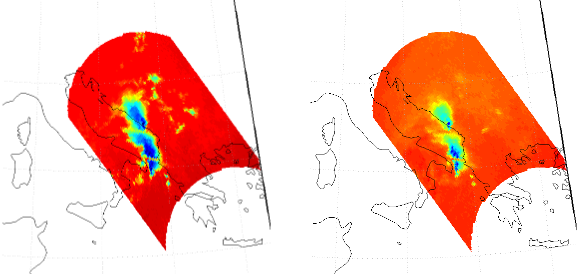
During early morning and morning on 20th February 2010 an extreme and rare flash flood event has occurred in the Portuguese island of Madeira in the North Atlantic, causing 42 casualties, 600 homeless and an estimated loss of around 1000 millions euros. In this presentation, the synoptic environment will be presented and the precipitation producing systems affecting the island will be discussed. The analysis will be mainly performed using satellite imagery from Meteosat 9, both from singles channels and RGB images, as well as from objective estimates of rain and water vapor content. Results from following studies on the precipitation regime of this mountainous island will also be presented.
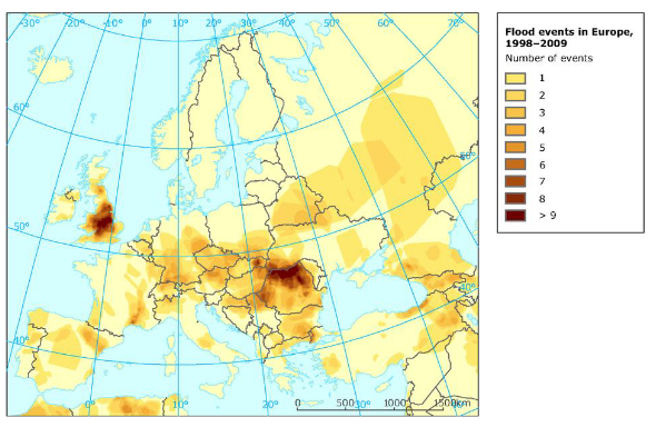
Natasa Strelec Mahovic investigates 5 years of flood events in Europe.
Length: 37 minutes.
In the last decade devastating floods occurred in Europe every year taking lives and causing great damages. In this presentation synoptic situations leading to the largest floods affecting Europe in the last 5 years will be analized. The main idea is to pinpoint the similarities and differences in synoptic patterns in order to improve the forecast of such events.
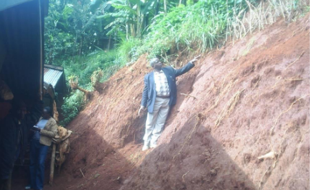
Joseph Kagenyi talks about forecasting land slides in Africa.
Length: 46 minutes.
The monitoring of weather characteristics over the equatorial and tropical regions is well covered with both polar and geostationary satellites hence the satellite becomes a very important instrument on severe weather monitoring and forecasting. The application of multispectral data of MSG in the monitoring the microphysics of clouds such as deep convective clouds with RGB composites provides in-depth understanding in the identification of regions where extremely active storms are located. The use of Multi sensor Precipitation estimate (MPE) also helps in the estimation total of accumulated rainfall on each region during the storm period. Such areas can easily be monitored and the possibility of excess rainfall within a day can be evaluated and such information is used to issue a warning for evacuation, or for support to the potential victims on these areas.
In short RGB composites, MPE Estimates, and the accumulated rainfall on daily basis becomes effective tools of landslide forecasting. We also add the NWP products particularly the High resolution (7 km) COSMOS data and NCEP CPC data as it gives a forecast with indications of possibly of heavy storms. However with satellite data you are able to ascertain which areas would the forecast show excess impact on the ground. The NWP products are used to help in creating accumulated rainfall values (estimates) necessary in establishing the threshold values for remote areas where station gauge data is not available.
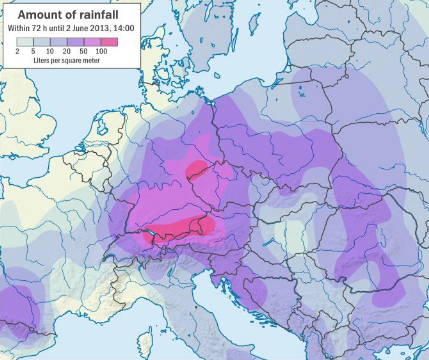
Natasa Strelec Mahovic reports on the precipitation event in spring 2014 which lead to inundations in SE Europe.
Length: 35 minutes.
From the beginning, spring 2014 was very rainy in large parts of central and south-eastern Europe. The soil was already saturated with water in the beginning of May, when mid-May a huge cyclone, persisting over Bosnia and Herzegovina, Serbia and Croatia for 3 days, caused extreme precipitation. The amounts measured in Serbia and Bosnia and along Sava river in Croatia were in some areas larger than ever measured before. Catastrophic flooding left thousands of people homeless and the consequences will be visible for a long time.
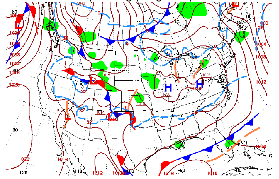
Gregory Carbin gives a presentation on the weather extremes of the winter 2014 in the US.
Length: 25 minutes.
The cool season months of 2014 (JFM) over the U.S. mainland can best be described as much colder than normal across portions of the Great Lakes, Northeast, and Midwest, and much drier and warmer than normal over the west coast, especially California. This talk offered a review of three aspects of the winter/early spring seasons. The first was a review of 12 UTC temperatures for every day in January across the continental U.S. and the relationship of some of the colder mornings with the longer-term record of January mornings back to 1979. The second event of note was the onset of exceptional drought in California. The third event, coming at the end of March, was a look at significant cyclogenesis off the U.S. eastern seaboard on March 25-26.
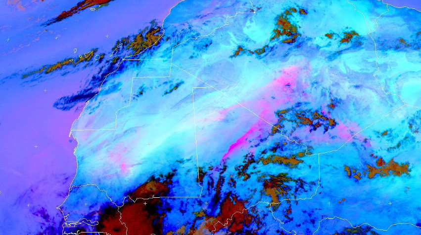
Hamidou Hama highlights the major socio-economic and environmental impacts of dust, focuses on the meteorological processes at various scales that are responsible for raising dust/sand storms in the arid Sahara Desert and the semi arid Sahel at its fringes.
Length: 40 minutes.
This presentation, after highlighting the major socio-economic and environmental impacts of dust, focuses on the meteorological processes at various scales that are responsible for raising dust/sand storms in the arid Sahara Desert and the semi arid Sahel at its fringes. The challenges facing the weather forecaster in forecasting such high impact weather phenomena and the importance of satellite remote sensing in their monitoring were also addressed here.
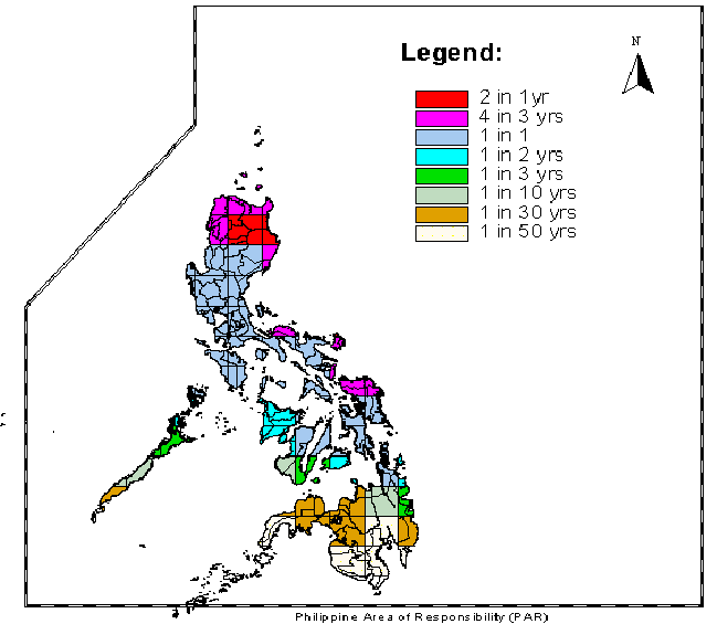
Christopher Perez gives an insight into Typhoons and their features.
Length: 35 minutes.
Christopher Perez, a weather forecaster of the Philippine Atmospheric, Geophysical, and Astronomical Services Administration (PAGASA) will gave an insight into Typhoons and their features. Specifically, he presented the chronology of events regarding Typhoon "Haiyan", one of the strongest tropical cyclones ever recorded, which devastated portions of Southeast Asia, particularly the Philippines, on November 8, 2013.
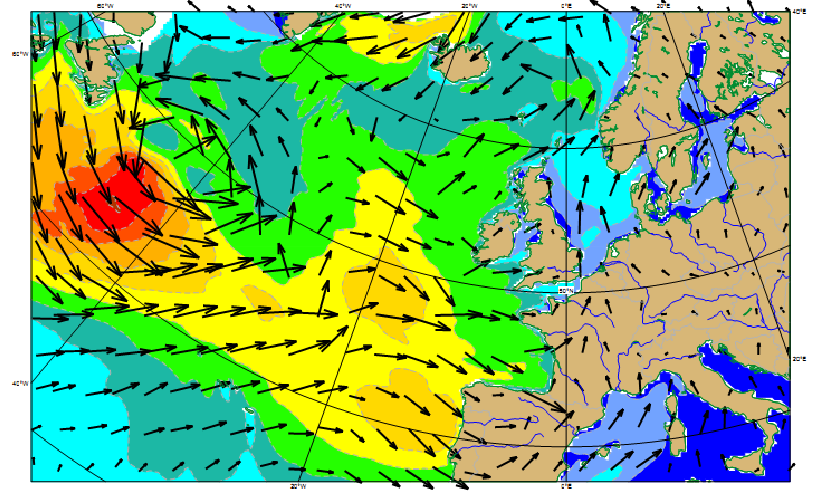
Jean Bidlot presents probabilistic forecasting based on ensemble technique to ascertain the probability of extreme weather, including wave parameters.
Length: 45 minutes.
For any operation at sea or in the coastal area, forecasts of the sea state are essential. The quality of those forecasts has steadily improved over the years as attested by the successful forecasts of the many large waves events that affected the Euro-Atlantic coast during last winter. Nevertheless, forecasts of high impact weather can still be uncertain. For this reason, probabilistic forecasting based on ensemble technique should be used to ascertain the probability of extreme weather, including wave parameters, as well as possible alternative scenarios. It is known that freak waves do occur and can result in major damages and losses. Predicting those events is more challenging, nevertheless advances in the theoretical frameworks for those situations have been made and has resulted in new forecasts parameters.