
Identify and interpret broad scale, synoptic and mesoscale systems
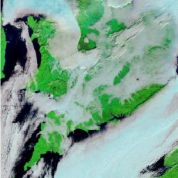
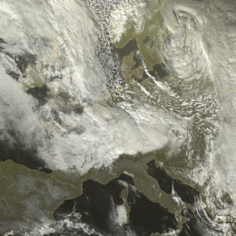
A five day period of dense fog was overcasting London Heathrow during Christmas 2006 severely disrupting air traffic.
This case study presents the synoptic analysis of an event that took place from the 18th to 23th December over the UK. During this period dense fog was covering many places in the UK causing extremely bad conditions for aviation. For a busy international airport like Heathrow the cancellation of hundreds of flights just at the peak travel season (a few days before Christmas) meant chaos and significant economic loss. Changes in travel plans affected at least tens of thousands of passengers.
Fog itself is a common event on the British Isles at this time of the year. However, the duration of the episode justifies a closer look at the event. In addition, the visibility within the fog was at times very low, and this heavily affected the air-traffic even at airports having the most advanced instrumentation for low-visibility flight operations.
This study concentrates only on the area in the southeastern UK, but basically similar synoptic conditions with reduced visibility at times prevailed also on the European continent during this episode. What makes this case study differ from many other case studies is the absence or small influence of atmospheric fronts or dynamic forcing (such as PVA or PV anomalies).
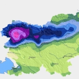
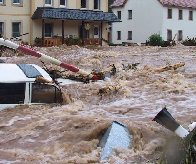
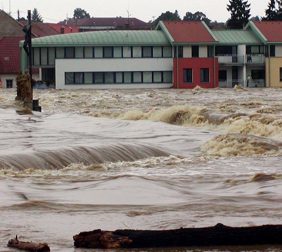
On 18 September 2007 Slovenia received 303 mm of rain in shy 24 hours. The result were flash floods and huge material damage.
This case-study presents the analysis of catastrophic flash floods in Slovenia that occurred on 18 September 2007. The flooding caused five casualties and huge material damage, estimated to more than 150 million Euro.
NWP models forecasted precipitation amounts of up to 100 mm/24h. That was the reason that the forecaster issued a warning for the precipitation at a rate of more than 100 mm/day, but the real values were much higher.
Besides analyzing synoptic and mesoscale conditions, that caused the extreme amount of precipitation, the objective of this study is also to show how nowcasting material can help a forecaster to issue additional warnings.
The synoptic analysis shows that on the day of the catastrophic event the area of low pressure was situated over the Northern Europe. A cold front was approaching the Alps and over Slovenia a series of prefrontal convective developments took place. In many regions in Slovenia the precipitation values were extremely high (>100 mm/day) with the maximum precipitation of 304 mm/24h officially measured in Kneske Ravne.
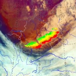
On 4th October 2007 a large Mesoscale Convective System hit the Balearic Island of Mallorca. Although the NWP model output did predict high convective activity, it did not expect it to take place near Mallorca.
On 4th October 2007 at 1530 UTC, a large Mesoscale Convective System (Mesoscale Convective System), passed over the Balearic Island of Mallorca. Associated to the Mesoscale Convective System an F2 tornado was reported. The Mesoscale Convective System was accompanied by severe wind gusts that spread the damage in numerous areas of the island. The longevity of the Mesoscale Convective System was quite remarkable (approx. 12 hours!), and in some stages of its life cycle, it showed a fast movement, taking a very short time, less than 1 hour, to cross Mallorca island.
A severe thunderstorm occurred at 5th of November 2007 in Cameli in the Western part of Turkey.
A severe thunderstorm occurred at 5th of November 2007 at Cameli town at the western part of Turkey. After the thunderstorms phone calls have been made by persons from the municipality of Cameli and with eye-witnesses. According to them, a small-scale tornado has been observed and three villages in the suburbs of Cameli have been affected.
Case Study on what happens when dry and cold air is transported over warmer seawater and moisture is picked up.
This a new example of the Conceptual Model, Convergence Lines over Seas and Lakes, is about a cloudstreet, developing into a well pronounced convergence line over the Sont, the narrow strait between Denmark and the southwest coast of Sweden. The evolution downstream over the west part of the Baltic Sea into the northwest part of Poland is studied as well. Coastal Convergence Lines, the other CM about developing convective clouds in cold air advection over warmer seawater, has a great similarity to convergence lines over sea and lakes. - Cloud streets, developed over sea, may intensify over land at a much larger distance from the coastline into an active squall line with embedded TS. An example of this side effect is presented as well.
From 29 February to 1 March 2008 storm Emma causes damage at several regions in Middle Europe. During only 12 hours a cold front and a succeeding convective line crossed Germany.
From 29 February to 1 March 2008, partly heavy thunderstorms with severe gusts and hail caused damages at several regions in Middle Europe. During only 12 hours a cold front and a succeeding convective line crossed Germany.
The storm Emma was a typical example of line convection with downbursts during a southeast movement of a storm field over the North Sea. The average velocity of the convective line was 110 km/h, sometimes 150 km/h. Behind the cold front dry atmospheric air (equivalent to high Potential Vorticity (PV)) could be recognised in the Airmass RGB.
Based on satellite imageries and numerical parameters the development of this event can be observed.
Case Study from China! On the 22nd of July 2008 was marked by a motion of a vortex with several convective cells along a frontal cloud band.
The 22nd of July 2008 was marked by a motion of a vortex with several convective cells along a frontal cloud band. At the leading edge of a frontal cloud system, lots of thunderstorms reported on the ground stations, and heavy rain, strong wind and lighten were observed. All of this weather events with caused enormous agriculture damage and economical lost. As the movement of vortex, several convective cells emerged and became a larger MCC because of merging each other, then the MCC was merged with a north MCC and brought severe weather in cloud area. So in this case, two different merging were analyzed in this case, first is the merger of cells and the second is a MCC merging with another one.
Case study on the abundant rainfall on 23 September 2008 in Valencia and Alicante.
On 23 September 2008 an amazing amount 326 mm in three hours was recorded in Sueca in the Province of Valancia. The convective events leading up to this event are discussed in this small case study by Ramon Vazquez. The satellite images as well as the radar and data from the ground are presented and discussed.
On 7th October 2008 a cold front crossed northwestern part of the Iberian Peninsula, producing large amounts of precipitation and causing disruption of same activities in the affected areas.
In northwestern Portugal, a maximum of 41 mm in 6 hours was obtained in an automatic weather station (AWS) in a mountain area and a maximum of 20 mm in 1 hour in a coastal area, both reaching the orange warning lower threshold for meteoalarm (40mm in 6 hours and 20mm in 1 hour, respectively). The Portuguese meteorological service (IM) issued a yellow warning with 24 hours advance, and the orange warning has been issued 7 hours before the beginning of the period of heaviest precipitation.
The Winter Storm Klaus occured from 23 to 24 January and has been one of those rare cyclones which leaved a serious path of damage, especially in northern Spain and southern France.
Reaching explosive development rates as high as 34 mb in 24 hours, and registered maximum surface wind gusts of the order of 200 km/h. Klaus cyclone, as a system with a clear surface pressure signal, approximately started on day 23 about 00 UTC, in the middle of the Atlantic, at position shown below, with a minimum MSLP value of 1000 mb, according to ECMWF / HIRLAM analysis. The track of the cyclone was purely zonal and its speed was markedly high, reaching values above 100 km/h. A minimum surface pressure of about 964 mb at cyclone center took place on day 24 at about 00 UTC, more or less maintained for several hours during the warm seclusion phase of the system.
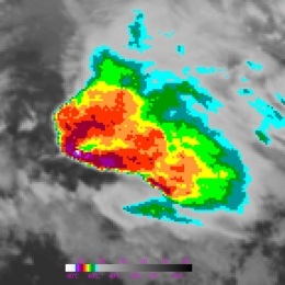
Torrential rainfall during the second week of September caused floods in the Istanbul area in Turkey.
Torrential rainfall during the second week of September caused floods in the Istanbul area in Turkey. As a result there were 32 casualties. Below we have pictured some satellite images with NWP. Striking is the Upper Level Low found over Central Turkey. This results in the advection of moist, unstable airmass from the Black Sea and topographic uplift which result in numerous rounds of showers and thunderstorms in the region. The cold temperatures found in the upper layers of the cold core low and its contrast to the warm surface causes the CBs to grow extreme in the vertical and producing lots of rain. Moreover, a weak wind field results in the slow storm movements.
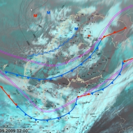
A particular strong wind event took place on 29 Sepetmber 2009. The event was characterized by a mesoscale convective line which was not reflected in any of the operational models.
A cold air outbreak took place in Finland on September 29, 2009. The most interesting part of this particular cold air outbreak was unexpectedly strong wind gusts. Operational models, except one, did not give a hint about strong wind gusts. The strongest observed gust was 30 m/s but fortunately no hazards or problems were reported from the sea areas around Finland. Newspapers reported some fallen trees and observations of roofs being blown off properties in southwest Finland. In this article, this particular event is evaluated and presented together with observational and operational model data.
Strong wind gusts also affected the standard measured 10 minute average wind speeds, so that the forecasted maximum was 12 m/s and the observed 20 m/s, which is close to official storm wind speed threshold in Finland. Operational forecaster on duty corrected forecasts quickly after observations showed higher than forecasted wind speeds.