Introduction: A conversation on the Phone - Part 2
On 13 June 2005 at 8h in the morning

"Good morning there is Mrs. Arts from the Open Air Opera in Mörbisch again. You asked me to contact you
today again. Our open air festivity starts at 20 h and the opera at 21 for about three hours. Do you have better news
for us today ?"

"Good morning Mrs. Arts. Let me have a look into the material already available."
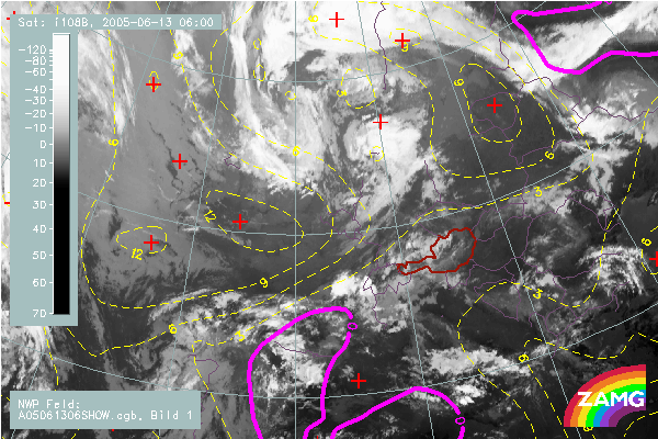
IR Satellite Image of 06 UTC; Blue: Thermal Front Parameter gives the location of the front at 06, 12 and 18 UTC;
Green: Aequivalent Thickness; indicates the frontal gradient as well as the warmest areas for 06, 12 and 18 UTC
Yellow/Magenta: Showalter Index; indicates the instability for 06,12,18 UTC; Negative values are highle unstable
A front (blue lines of TFP) is rather stationary over West Austria but merges during the day in the northern parts with the TFP of a growing comma feature. In front of this system a thickness ridge representing warm air intensifies and moves eastward. The Showalter index (yellow and magenta lines) indicates instability with high possibility of showers and thunderstorms already at 06. During the next 12 hours the Showalter index becomes more negativ representing a more unstable airmass.
"Sorry to say this Mrs. Arts , but at the time being I cannot give you a rain- and thunderstorm free signal. There is the cloud band of a front which moves slowly eastward and leads to thunderstorms immediately before it arrives. The Instability index shows increasing values till 20 h. So the probability for the development of thunderstorms is very high but at this point of time it is not possible to say where the thunderstorms will develop. If you are lucky they are only close to your area. Please call us again about one hour before the begin of the opera. Then we know already where thunerstorms are and we can estimate their future path and development."
Follow
this link
to find out what happens next!