Introduction

"In "Basic Nowcasting" monitoring and a qualitative estimation of the future movement are the main tools. For a "Quantitative Nowcasting" measures for advection and change must be computed. One of the most imporant tools are Motion Vectors. They can be computed from many different patterns, but here we are concentrating of structures in IR images which are named "Cloud Motion Vectors". The computation of Cloud Motion Vectors (CMVs) can of course be used for determining a rather exact passage of cloud systems and sometimes even of cloud layers within bigger scale cloud systems. Lets look into an example and evaluate the nowcast charts together."

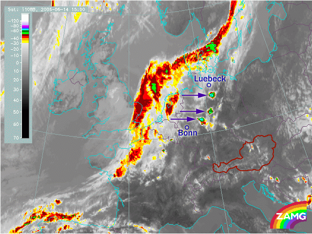
The cloud band of a coldfront lies over west and NorthEurope. It extends from France (Brittany) across the North Sea and Denmark to SE- Sweden. Over the North Sea the typical cloud bulge of a wave can be seen. In front of the frontal cloud band some typical convective cells have developed; they can be seen between the German cities Bonn (South) and Lübeck (North).

"Lets now go into Nowcasting questions!"

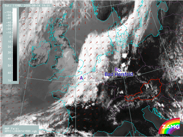
These vectors are CMVs. They show the direction and intensity of displacement of the cloud features. So for example:
The rearward edge of the frontal cloud band over the English Channel (A) moves to the ...
The rearward edge of the frontal cloud band over the English Channel (A) moves to the ...
- East
- Northeast
- North
- Northeast
- East
- Southeast

"Oh, this is nice and seems to be rather simple. Is it really so simple in nature? Weather system do change?"

"Of course, you address exactly the point. What we discussed now is only the advective part of nowcasting. From this you get only an indication which of the cloud, rain, lightning systems will become important for your nowcast.. As a nowcast meteorologist you have to monitor theses systems carefully. Each 15 minutes you get the new stage and location of the cloud and weather system."

"So with this method I can only nowcast an already existing cloud system and its weather. Are there methods to get information about developments and intensity changes before they happen?"

"This is the big job meteorology is working on in many weather centers. From satellite imagery alone you can get still some steps further - think of the development stage which you saw above; but there is not yet any complete and accepted method. There seems also to be some improvement from combiantion of channels. But nevertheless for a mere satellite nowcasting there is a clear limit of the possibilities. You definitely will get further with relevant and typical parameters from numerical models in combination with satellite data and satellite nowcasting methods; but this it is still in the beginning of research. And of cause all centers working on LAM models work also on nowcasting.
We will treat these topics in a later lesson. For now, let's look at a more detailed treatment of CMV computation."
We will treat these topics in a later lesson. For now, let's look at a more detailed treatment of CMV computation."
"Follow
this link
to continue!"