Fronts
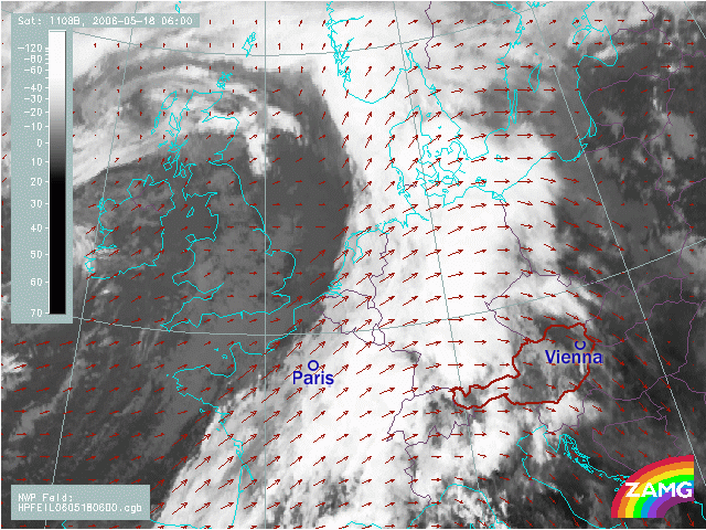
At 06 UTC Paris lies in that cloud part which has clearly warmer cloud tops: looking in to the false colour image (next) the green colour indicates cloud tops of -15 to -40°C. In the exercise done under "Basic Nowcasting" you had to look into the sequence from 03 to 06 and guess if Paris will get to the rear side between 06 and 09. The answer was "It will be very close to or immediately at the rearward edge". Try it now with the quantitative Nowcasting.
"Now after the examination of the satellite images of this case study try to answer the following table; what features of nowcasting can be answered for frontal cloud systems and to which extent from a sequence of basic IR images alone?"
| Answer Possible | No answer possible, but some hints | No answer possible | |
| Arrival Time of Frontal Cloud | |||
| Low/High Multilevel cloud | |||
| Arrival of surface front line | |||
| Arrival time of rain area | |||
| Existence of implemented thunderstorms | |||
| Nowcasting of wave development |
"If you compare our first exercise in "Basic Nowcasting" where we estimated the movement of the frontal cloud band across the cities from a sequence of images with the last exercise which is quantitative nowcasting with help of CMVs we used now - is there any improvement?"
"Well, in our first qualitative exercise we came quite often to a right but somehow diffuse answer.
For instance Paris, we said "It will be very close to or immediately at the rearward edge between 06 and 09"; from the quantitative method the answer was "Only at 8.45 we can decide that Paris will get finally behind the cloud band at 10.45". This is a discrepancy which came from the fact that that the computation of the SW-NE movement of the cloud features which showed a longer stay under the cloud band or close to the rearward edge."
For instance Paris, we said "It will be very close to or immediately at the rearward edge between 06 and 09"; from the quantitative method the answer was "Only at 8.45 we can decide that Paris will get finally behind the cloud band at 10.45". This is a discrepancy which came from the fact that that the computation of the SW-NE movement of the cloud features which showed a longer stay under the cloud band or close to the rearward edge."
"Well this is not only a win in time but also a win in knowledge about the ongoing processes."
"Yes. For Vienna we estimated in our qualitative exercise from the image sequence between 00 and 03, that "Vienna will leave the cold front cloud band and move into the rear side till 06." From our quantitative Nowcast method we could clearly decide "at 04 that Vienna will leave the frontal cloud band at 06". In this case both methods were very close. But you are right: the quantitative computations were more exact and gave more confidence and security to the forecaster."
"Do you think that this will be similar for our convective case example?"
"Well convective cells are smaller in size; from this the difference between the qualitative and the quantitative method should be less. Or? Am I right or wrong?"
"Let's do some exercises and see."
"Follow
this link
to begin!"