
Aviation
Listed here are other resources related to Aviation tag:
Note: click on an image to open the Resource
Elina Tuhkalainen treats the formation and dissipation of fog at airports in Finland.
Length: 35 min
Author: Elina Tuhkalainen (FMI)
In this presentation formation and dissipation of fog and stratus will be treated. The presenters will also address how these phenomena occur around the year and how they affect the services at the airports in Finland.
The presentation shows a possibility of turbulence diagnostics with aid of the Turbulence Kinetic Energy (TKE).
Length: 50 min
Author: André Simon, Péter Salavec (OMSZ)
Turbulence is a hazardous weather phenomenon for aviation and a challenge for a forecaster. It is typically a small-scale phenomenon and its direct observations and measurements are relatively sparse, except of the surface layer of the atmosphere. The presentation shows a possibility of turbulence diagnostics with aid of the Turbulence Kinetic Energy (TKE) calculated from a high-resolution non-hydrostatic model AROME. This parameter is calculated from a prognostic equation and it is only rarely applied as an end-product in operational forecasting. We studied the distribution of TKE in various meteorological situations, with focus on the Visual Flight Rules (VFR) conditions. Both advantages and limits of the TKE diagnostics are discussed. High attention is also given to forecasting of mountain waves, which can have both positive and negative impact on the flight. A development work based on this theory is in progress at the Unit of Aviation Meteorology resulting in new products for the mountain wave gliding branch of sport aviation.
Kris Bedka talks about methods helping to detect hazardous weather situations for aviation.
Length: 30 min
Author: Kris Bedka (NASA)
Current generation geostationary satellites are observing convection that is hazardous to aviation at increasingly high spatio-temporal detail. In recent years, commercial and research aircraft have collected automated turbulence and cloud ice water content observations that can be used to better understand exactly where within deep convection the turbulence and icing conditions are typically occurring. Ground-based weather radar and severe weather reports also identify locations of hail, downburst wind, and tornadoes. Research conducted at NASA Langley Research Center (LaRC), in collaboration with a number of U.S. and international partners, has resulted in geostationary-based analyses and automated detection algorithms that can denote where turbulence, icing, and severe weather conditions are likely. These methods are applicable to any geostationary visible and IR imager across the globe and therefore can be used to map these weather hazards in nearreal time, a capability that is especially valuable over regions without weather radars and other conventional observations of aviation hazards.
Alexander Jann and Andreas Wirth present the new aviation products of ASII-NG (Next Generation).
Length: 30 min
Author: Alexander Jann, Andreas Wirth (ZAMG)
Two new satellite-derived products related to turbulence analysis have been developed recently in the frame of the Nowcasting-SAF. The first product (ASII-GW”Automatic Satellite Image Interpretation – Gravity Waves”) objectively detects grating patterns in the water vapor 7.3 imagery which point to the presence of gravity waves. The second product (ASII-TF “Automatic Satellite Image Interpretation – Tropopause Folding”) identifies the location of tropopause folds from satellite and NWP data. The algorithm is based on the logistic regression method.
In this presentation, we will talk about the selected algorithms and present cases from the official Nowcasting-SAF validation reports (to be released shortly) to illustrate the product performance.
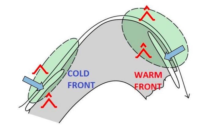
Peter Schmitt analyses the different aspects of CAT and presents a CAT forecasting method.
Length: 40 min
Author: Peter Schmitt (DWD)
Clear air turbulence (CAT) is the term for medium- or high-level turbulence in regions with significant wind shear. CAT is an important factor for the aviation safety.
In the first part of the presentation, I will show you typical parts of CAT in relation with the 300 hPa geopotential analysis. Furthermore you get an overview to the correlation between CAT and characteristic cloud patterns in satellite images. In many cases satellite images provide the first clue or a confirmation for the presence auf CAT.
The second part is dedicated the forecast of CAT in Deutscher Wetterdienst (DWD) with the ICON model. DWD has been applying a forecast method based on Eddy Dissipation Rate (EDR). This real property of atmospheric turbulence is the main sink term of Turbulent Kinetic Energy. In a case study you will see the typical working process in practice with consideration of the model output, typical cloud pattern in satellite image and the use of the conceptual model and the structure of geopotential field.
Ab Maas shows which items are of main importance for balloon forecast e.g. accurate wind forecasts, starting and dying out of thermals and convection.
Length: 60 min
Author: Ab Maas (former KNMI)
Aviation meteorology is a wide field in terms of forecasting and forecasting product. Not only is there a big difference between the civil aviation part and General Aviation (GA), but also in GA there are a lot of specific customers who needs specific forecasts; VFR forecasts for small planes, gliding, paragliding, ultra-lights, ballooning etc.
Ballooning forecasts can also differ, e.g. the commercial balloonists need other forecasts than balloonists in competitions and championships and gas balloons can fly in weather circumstances where it is impossible for hot air balloons.
In the presentation it will be shown which items are of main importance for balloon forecast e.g. accurate wind forecasts, starting and dying out of thermals and convection. And also how surface observations, radio soundings, satellite and radar can be of help.
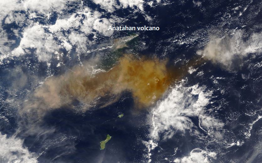
Fred Prata presents a series of volcanic eruption and analyses them from the satellite perspective.
Length: 65 min
Author: Fred Prata (AIRES Pty Ltd)
Since the late 1970's earth-orbiting satellites have been able to observe the weather around the globe and provide quantitative information on cloud movements. These data have proved extremely valuable for tracking volcanic ash clouds and more recently allowing quantitative information on volcanic ash column amounts and also on SO2 gas - another potential hazard to aviation. Notable incidents between commercial aviation and ash clouds, several in Indonesia and Alaska, have occurred during the satellite era (~1960's onwards). The talk will cover methods used to identify, quantify and monitor volcanic ash clouds and frame this in the context of the potential hazard.
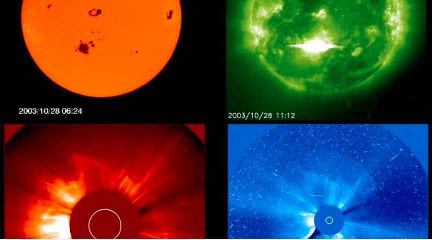
Roland Winkler presents the impact of space weather on aviation.
Length: 55 min
Author: Roland Winkler (AustroControl)
In the field of aviation the space weather plays an increasingly important role. Due to economic factors, flights in the higher latitudes, respectively in the polar regions, continue to increase year by year. In the presentation, which was divided into three parts, Roland explained the term of space weather or the cosmic radiation. In the second part, Roland gave a brief overview of the individual components of space weather. In the third part, which at the same time represents the main part of the lecture, he presented why the number of flights in the polar regions is strongly increasing and which dangers by the space weather on the air traffic and the passengers or the cabin crews can arise.
Roland Winkler talks about rules and regulations that are in place at airports to provide passenger security in harsh winter weather.
The weather still has a major impact on aviation today. Weather forecasts in aviation not only support safety, but also provide important input on the subject of economical air traffic. As part of this presentation, I would like to give a rough overview of how air traffic works in the cold season. I will speak about de- and anti-icing of aircraft and the snow removal in the airside area. Finally, I will show which meteorological products are created to support safe and economical air traffic.