
High level lee clouds
Thick ice clouds are depicted in red or yellow colours in the Severe Storms RGB images. In the areas where the particle size is small and/or the cloud top is very cold it appears yellow.
The high level lee clouds are very cold and consist of very small particles. (Homogeneous freezing processes at very low temperatures typically lead to the formation of very small ice particles. Furthermore at the height they form the available humidity is rather low.) As a consequence the thick part of the high level lee cloudiness usually shows up in bright yellow colour tones. The thin parts are pinkish.
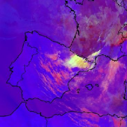
The image below shows a Severe Storms RGB image. High level Lee clouds are seen south of the Pyrenees and Cevennes. The bright yellow colour indicates the presence of very small ice particles.

Meteosat, SEVIRI, Severe Storms RGB image for 17 May 2007, 10:10 UTC
The next image shows high level lee clouds formed over several mountains: the mountains of Corsica, the Apennines, the Dinaric Alps and the Carpathian Mountains.
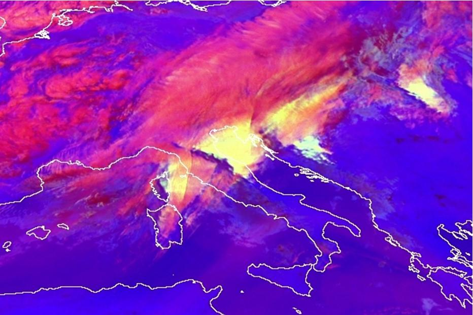
Meteosat-8, SEVIRI Severe Storms RGB image from 19 March 2007, 08:00 UTC
The image below shows high level clouds south of the Alps over Italy and Adriatic Sea. East of the Alps over France we see also high level lee clouds. Note that in this case the lee cloud is rather whitish than yellow.
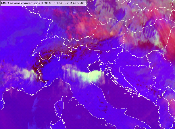
Meteosat SEVIRI, Severe Storms RGB image from 16 March 2014 09:40 UTC
Explanation of the colours of thick high level lee cloud (see the recipe):
• The difference (WV6.2 – WV7.3) is usually negative, but for thick high ice clouds it is around zero resulting in intense signals for the red colour beam.
• The difference (IR3.9 – IR10.8) is large because the cloud top is very cold and it consists of small particles resulting in intense signals for green colour beam.
• The difference (NIR1.6 – VIS0.6) is usually negative for ice clouds (much lower reflectivity around 1.6 than around 0.6 micrometer). However, if the particles are small the NIR1.6 reflectivity increases resulting ‘considerable’ signal in blue colour beam. If the ice crystals are extreme small the signal may become high.
As a consequence the signal will be intense in the red and green colour beam and also ‘considerable’ in blue colour beam. It is the difference of the (NIR1.6-VIS0.6) channels which determines whether the resulting colour will be bright yellow or in extreme cases whitish.
Note that small ice crystals may form not only in high level lee clouds. Small ice crystals can as well be observed: on top of storms with intense updraft, on the tops of storms with cold (high) cloud base and on the tops of polluted thick ice clouds.