Chapter II: Physical snow characteristics determined from space
Table of Contents
- Chapter II: Physical snow characteristics determined from space
- Satellite instruments' sensitivity
- Snow detection in the visible spectrum
- Snow detection in the infrared spectrum
- Snow detection in the microwave spectrum
- Factors which may lead to misidentification of snow
Satellite instruments' sensitivity
For climatological and hydrological purposes it would be useful to know the areal extent of snow, its water equivalent, grain size, density and presence of liquid water. However, these properties cannot be measured directly by remote sensing systems. Satellite instruments measure radiation in certain ranges of the electromagnetic spectrum, and with the correct processing techniques this data reveals properties of the snow cover (Table 1).
Table 1: Satellite instruments' sensitivity to various snowpack properties in different regions of the electromagnetic spectrum (adapted from WMO CHy-14, 2012).
| Region of electromagnetic spectrum | ||||
|---|---|---|---|---|
| Snow property | Gamma rays | Visible/NIR | Thermal infrared (IR) | Microwaves |
| Snow-covered area | Low | High | Medium | High |
| Depth | Medium | If very shallow | Low | Medium |
| Water equivalent | High | If very shallow | Low | High |
| Stratigraphy | No | No | No | High |
| Albedo | No | High | No | No |
| Liquid water content | No | Low | Low | High |
| Temperature | No | No | Medium | Low |
| Snowmelt | No | Low | Low | Medium |
| Snow-soil interface | Low | No | No | High |
| Additional characteristics | ||||
| Surface seen through clouds, day and night | No | No | No | Yes |
| Current best spatial resolution from space platform | Not possible | 10 m | 100 m | 25 km passive 10 m active |
Snow detection in the visible spectrum
The reflectance values of different surfaces can be plotted as functions of wavelength called "spectral response curves" or "spectral signatures" (Fig. 1). Differences among the spectral signatures of landscape features are used to classify remotely sensed regions, since the spectral signatures of similar features have similar shapes. Snow cover has a high surface reflectance in the visible part of the spectrum (VIS), and is represented as a white region in visible images. However, in the visible spectrum, it may be difficult to distinguish snow from other Earth features, such as clouds or bright sand. Snow retrieval from optical satellite measurements requires clear skies and sufficient daylight. This limits the applicability of satellite measurements for snow detection. In short-wave infrared (SWIR) snow has a low reflectance and this enables distinguishing between snow and other bright surfaces.
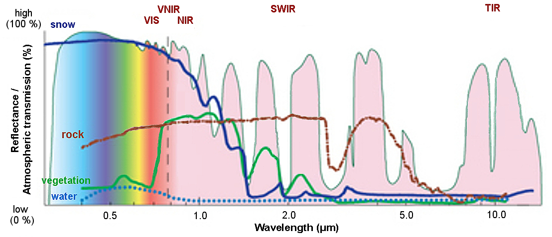
Figure 1: Reflectances of different surfaces. Credit: Andreas Kaab, University of Oslo.
Exercise 1
Which feature has the spectral signature most similar to snow in the visible spectrum?
The correct answer is: b) Clouds.
At all wavelengths of visible light, clouds have very similar reflectance values as snow. This makes it difficult to distinguish these two features.
Snow detection in the infrared spectrum
Snow and ice are good reflectors of visible radiation but reflect near-infrared (NIR) poorly. NIR data shows high reflectance for water clouds, medium reflectance for ice clouds, and very low reflectance for snow cover. A comparison of the spectral response patterns of snow and other land cover types reveals that: 1) snow has a higher contrast between the VIS and SWIR spectral regions; 2) snow has relatively higher reflectance in the VIS region compared to that of other land types like water, soil and vegetation; 3) snow, like clouds, has higher reflectance values in VIS, while in the SWIR region it has much lower reflectance. This can be used to differentiate snow from clouds. Thermal infrared data can be used to identify the edges of snow cover. Short-wave and thermal infrared data combined with visible channels are useful for discriminating between clouds and snow (WMO CHy-14, 2012). Stronger absorption by snow and ice at short-wave infrared wavelengths helps to distinguish these features from liquid-phase clouds, but some uncertainty remains between snow on the ground and ice-phase clouds.


Figure 2: Snow cover in the visible and thermal MSG channels (4 February 2014): in the top image in VIS 0.6 μm, in the bottom image in IR 10.6 μm. It is difficult to distinguish snow and clouds in both the visible and infrared spectrum, although a combination of information from VIS and NIR can help (see Chapter 2).
Snow detection in the microwave spectrum
Microwave (MW) instruments sense much longer wavelengths than infrared radiometers, and this energy can be expressed in units of frequency called gigahertz (GHz). The frequencies for meteorological observations fall in the range of about 5 to 200 GHz or 6 to 0.15 cm wavelength. The amount of microwave radiation emitted by the Earth's surface depends on the type of surface and its characteristics (roughness, moisture, vegetation, snow cover, etc.) (Fig. 3). Microwave emissions depend strongly on the physical properties (e.g. atomic composition and crystalline structure) of the object.

Figure 3: Surface features that have different characteristics in the microwave spectrum. Credit: COMET®.
Contrary to the visible and infrared spectrums, microwave energy is emitted not only from the surface of the snowpack, but also from deeper layers. It is sensitive to snow depth, snow water equivalent, snowpack temperature, wetness degree and soil conditions below the snowpack.
The two properties of emitting material that have a significant impact on emitted microwave radiation are polarization and the dielectric effect (relative permittivity). Polarization defines a group of simple waves comprising a radiation signal, while the dielectric constant is very sensitive to water and has a direct impact on absorption and emission efficiency. Each property is dependent on the wavelength and physical characteristics of the emitting and/or reflecting material. These properties of microwave radiation allow discriminating between solid, liquid, and frozen elements on both land and ocean surfaces (Fig. 4).

Figure 4: Microwave emissivity for common surface types. The differences in emissivity serve to differentiate different types of snow and to distinguish snow from other features. Credit: COMET®.
Exercise 2
Take a look at Fig. 4 and answer the following question:
At what frequency (GHz) it is easiest to distinguish the wet snow, dry snow and re-frozen snow?
The correct answer is: c) 30 - 40 GHz.
At this frequency there are highest emissivity differences between these three different snow types.

The physical characteristics of snowpack determine its microwave properties. Microwave radiation emitted from the underlying ground is scattered in many different directions by the snow grains within the snow layer, resulting in the microwave emission at the top of the snow being weaker than those from the ground (Fig. 5). Properties affecting a snowpack's microwave response include depth and water equivalent, liquid water content, density, grain size and shape, temperature and stratification as well as snow state and land cover (WMO CHy-14, 2012). These characteristics of snowpack and the snow's morphology are strongly correlated with climate.

Figure 5: The scattering of microwave radiation depends on snow depth, density and grain size. Credit: COMET®.
Vegetation emits microwave radiation of its own. In areas where vegetation covers at least part of a snow-covered surface, the brightness temperature sensed by the satellite increases (Fig. 6). Forest cover masks snowpack microwave emissions. The more vegetation, the less snow cover a satellite can observe directly. By using a multi-spectral approach to the analysis, the vegetation can be identified and its effects minimized.

Figure 6: Vegetation increases the emission of microwave radiation and thus masks the snow signal. Credit: : COMET®.
The 37 GHz microwave channel is often compared to the 19 GHz channel to differentiate dry and wet snow. The 37 GHz MW data is sensitive to snowpack scattering while 18-19 GHz data is relatively unaffected by snow (Dong et al., 2005). By taking the difference of the two channels, different snowpack characteristics and snow melt can be determined, which would not be possible with 37 GHz observations alone.
Snow cover characteristics sensed in the microwave spectrum (e.g. snow water equivalent) are difficult to retrieve in mountainous terrain due to the variability of snow cover and complex orography. Retrieval of snow water equivalent is also problematic over frozen ground, cold deserts, and ice sheets (Greenland and Antarctica). MW snow products are degraded along coastlines, in urban areas and other regions with highly variable surface types.
The big advantage of microwave instruments is that they can sense the ground despite cloud cover. MW channels also work during both day and night. Their main shortcoming is spatial resolution - it is 10 times less than for instruments working in the visible or infrared spectrum (Takala et al. 2011).
Exercise 3
Choose word to get the correct statements about snow detection in microwave spectrum. (Use the selection box to choose the answer that best completes the statement.)
Factors which may lead to misidentification of snow
There are several features of satellite imagery that must be taken into consideration in order to prevent the misidentification of snow and snow-free areas in the final composite.
1. Clouds
Cloud tops exhibit a very bright reflectance in the visible spectrum and are often indistinguishable from snow. Differentiating between clouds and snow is one of the major problems in the use of satellite data for snow mapping. Snow can be distinguished from clouds by using near-infrared and short-wave infrared channels because clouds reflect noticeably more radiation than snow in these regions (Crane and Anderson, 1984; Dozier, 1984).
2. Forest cover
Forested areas can consist of anything from dense conifers to less dense deciduous forests to sparse range-type vegetation. The reflectance of these areas will be considerably lower than non-forested areas even with substantial depths of snow, since the snow signal will be blocked by the forest canopy. Vegetation indexes can be used to identify the forested areas and additional multi-spectral thresholds can be applied to determine if the forest floor is covered with snow.
3. Shadows
During the winter, sun angles are generally low and the resulting northern hemisphere terrain shadows on north-facing slopes with snow cover may be difficult to distinguish from bare south-facing slopes. Topographic maps and summer imagery may help in the interpretation. In shadowy areas, snow may be distinguished from rocks or soil by selecting a threshold brightness temperature (Dozier and Marks, 1987).
4. Rocks
During the melt period, highly reflecting bare rock may be difficult to distinguish from late season snow. Also, the spectral response of cold rocks is similar to snow in the microwave spectrum. Summer imagery and topographic maps, as well as vegetation patterns, can help in the differentiation.
Exercise 4
Try to identify snow in image (VIS 0.6) by drawing the areas on MSG image of 2013-03-22. When you are done drawing click the first Done button to see the snow covered areas and the second one for an explanation.
Snow detection is easier if you are familiar with the geography and climatology of the region (e.g. if you know where are the mountains, big water bodies, what are the seasonal differences and cycles).