Effect of undetected clouds
The convective environmental parameters are retrieved for cloud-free pixels only. The NWCSAF/MSG Cloud Mask module is used to differentiate cloudy pixels from cloudless ones. For pixels containing some clouds that were not detected by the cloud mask, the SPhR algorithm retrieves water vapor content and atmospheric instability. The retrieval often indicates overly high water vapor content and instability for these pixels, or the retrieval fails entirely. This happens most often with very thin cirrus clouds and near cloud edges.
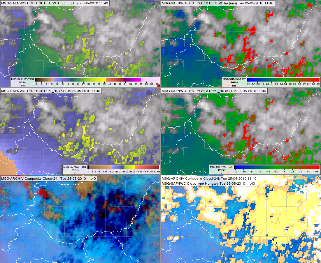
Figure 1: Meteosat SEVIRI images from 25 May 2010, 11:40 UTC. Satellite-retrieved TPW (upper left), K-Index (middle left); the differences between the satellite-retrieved and the ECMWF forecasted TPW (upper right) and K-Index (middle right), respectively. Bottom left shows the 24 hour Microphysics RGB. In the bottom right panel the same RGB is shown overlaid with the NWCSAF/MSG Cloud Mask product (presented in white, yellow and light orange colors).
Fig. 1 shows the effect of undetected cirrus clouds. The bottom left panel presents the 24 hour Microphysics RGB image. In this RGB the dark blue colors indicate thin cirrus clouds. In the bottom right panel the same RGB is overlaid with the NWCSAF/MSG Cloud Mask product (presented in white, yellow and light orange colors). In the cloudless area one can still see some dark blue pixels, which likely contain thin cirrus clouds that went undetected. In these pixels the differences between the satellite-retrieved and ECMWF forecasted TPW (upper right panel) and K-index (middle right panel) are high - more than 3 mm and 7 °C, respectively. Further away from these pixels, in areas that seem to be more reliably cloud-free, judging by the light blue color in the RGB image, this difference is around zero or slightly negative. These pixels also exhibit high TPW and K-index values (top and middle left panels). Note that the effect of the undetected clouds are not always so strong, but frequently observed.