Chapter IV: Fire types
Table of Contents
Classification of Fires
With all the information you now have on fires, you can understand why forest fires may be classified according to different criteriathroughout the literature. Let us take a look at some such classifications.
Rate of Spread
The spread rate of a fire can be low or high, thus affecting the combat. It depends on parameters like wind speed, wind variability, topography and fuel consumption.
Level
Fires may occur at different levels. You are probably familiar with fires that burn the surface litter (surface fire) and fires that burn the tree crowns (crown fire).
The crowning (the stage of a fire in which the crowns start to be involved) depends on the height of the crowns, on the foliar moisture content, on the rate of spread of a fire and on the consumption of fuel at the surface.
There is a third type of fire, of which you may not have been aware - the ground fire. It may be invisible to the human eye as it takes place in the humus layer.
(Forestry Canada, 1992, p34-p36)
Fuel Consumption
Fires may also be characterized by the fuel they consume. Fuel consumption includes surface fuel and crown fuel:
- Surface fuel consumption estimates are based on experimental fire data and may be derived from indexes like FFMC (Fine Fuel Moisture Code) and BUI (Build-up Index) which account for fuel availability and are integrated in the Canadian Fire Weather Index (FWI).
- Crown fuel consumption depends, logically, on the crowning of the fire; therefore, it depends on the ingredients for crowning seen above.
(Foresty Canada, 1992, p20-21, p37-38)
Head Fire Instensity
The head fire intensity is defined as the rate of heat energy release per unit time per unit length of a fire front. It accounts for both the fuel consumption and the spread rate of a fire, giving an idea of the difficulty of controlling a fire and thus being of very useful for firefighting.
You may also see this parameter referred to in the literature as frontal fire intensity or line fire intensity.
(Foresty Canada, 1992, p38).
Source
When examining the development of surface fires from ignition to a steady state of spread (for example in experiments), the source of the fire is an important factor. Fires are frequently split in two types according to the source; point-source fires and line-source fires.
- Point-source fires are those in which ignition occurs in a single point.
- Line-source fires are those in which ignition occurs along a line.
Forestry Canada, 1992, p39 and p42, Kucuk at al, 2007, p264
Weather Forcing
Fires may be also classified according to the weather conditions forcing its development:
- Wind-driven fire
Fire in which the wind plays the major role in its development. The Haines Index cannot be used in this case, but the indexes that include surface wind fields can! - Plume-dominated fire or convection-driven fire
Fire that is mainly driven by a local wind that is generated in response to strong convection above the fire. It depends strongly on the stability of the air column and the Haines Index can be used to predict its growth.
Potter et al, 2002.
Growth and Propagation
The following terminology is regularly used in classifying the growth and propagation of fires:
- Spotting - Method of fire growth, in which firebrands (or burning embers) are lifted outside the fire perimeter by the smoke column (Werth and Ochoa, 1993, p.223).
- Head fire - Fire ahead of the ignition point in the direction the wind (see Figure 4.1).
- Back fire - Fire to the back of the ignition point, in the opposite direction of the wind (see Figure 4.1). Parameters like "back fire rate of spread" and "back fire intensity" are usually used to describe fire behaviour.
- Flank fire - Fire ahead of the ignition point, but spreading perpendicularly to the direction of the wind (see Figure 4.1). Parameters like "flank fire rate of spread" and "flank fire intensity" are usually used to describe fire behaviour.
(Forestry Canada, 1992, p.43)
NOTE: the term back fire is sometimes used to describe a fire that is started (by fire managers) to stop an advancing fire by creating a burned area in its path.
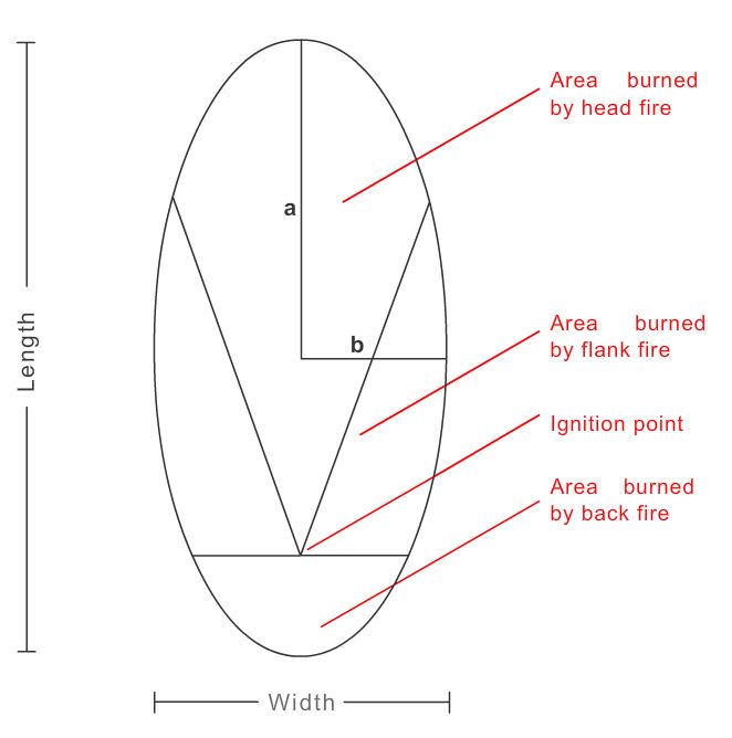
Fig 4.1 - Typical oval shape of a wind-driven point-source fire, assuming the wind direction remains relatively constant. Representation of the ignition point and the areas burned by head fire, flank fire and back fire (Forestry Canada, 1992).
Pyrocumulus Development
Question
If the atmospheric environment is favorable, cumulus may develop due to fires, as the lower tropospheric layer is heated, decreasing static stability:
The correct answer would be "True"
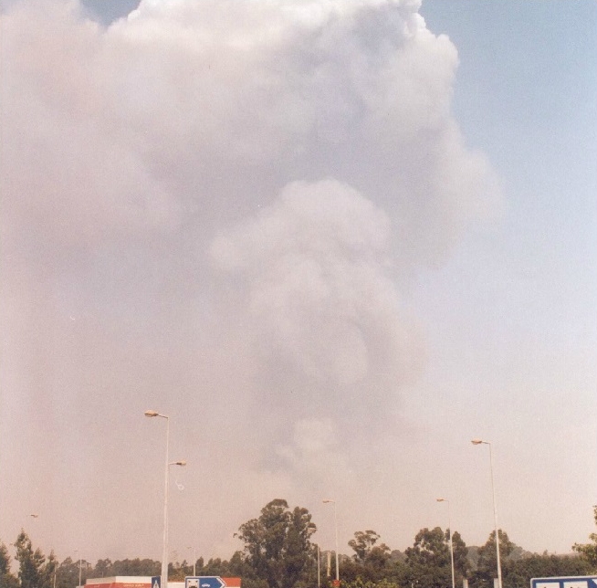
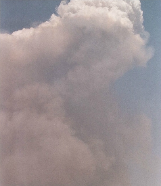
This can really happen! Then these clouds are usually called Pyrocumulus!
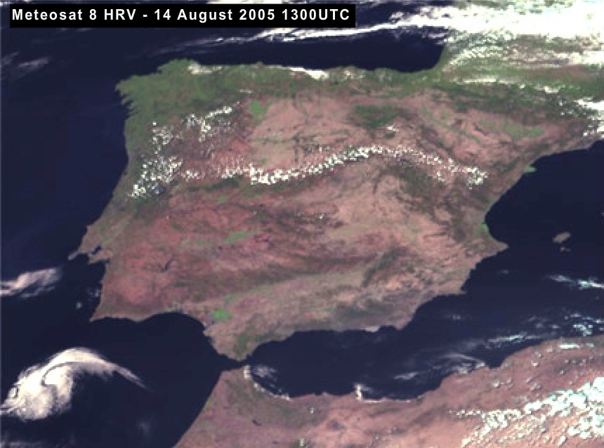
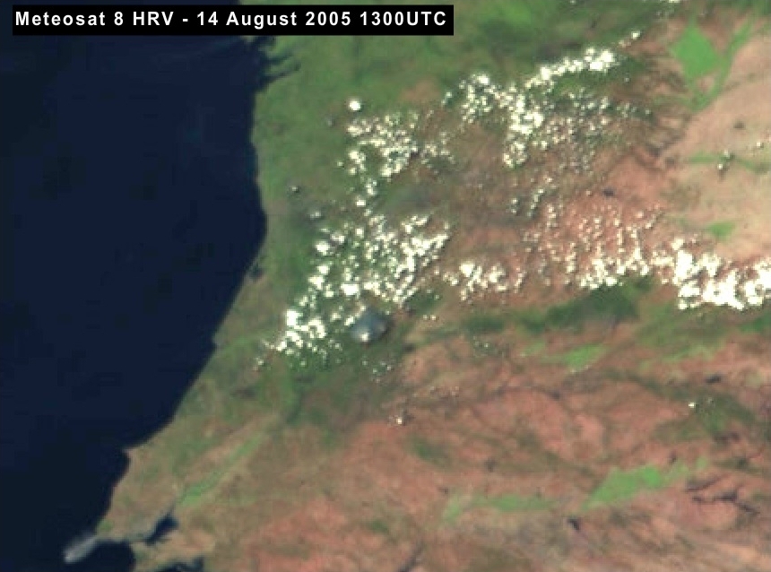
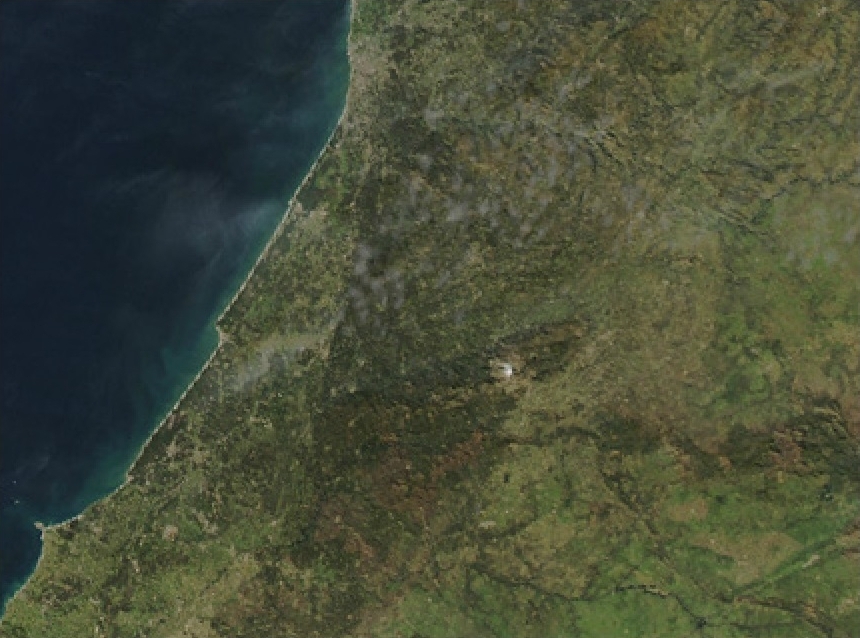
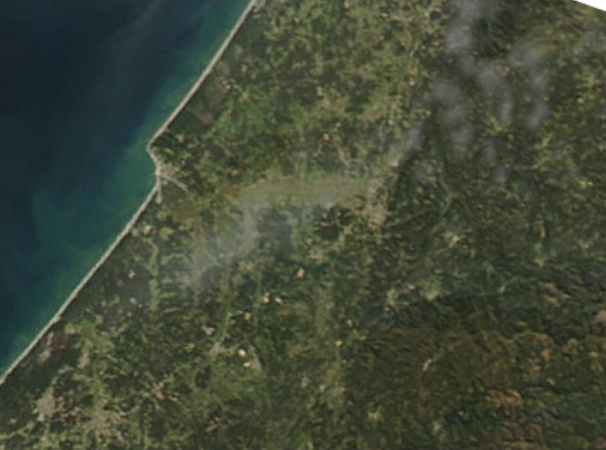
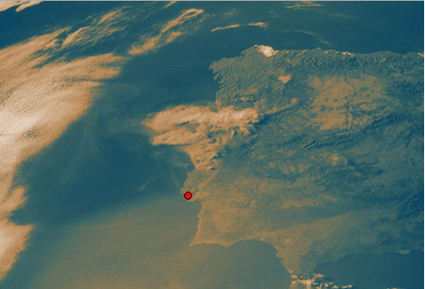
The satellite image below is from Meteosat 8 High Resolution Visible channel. The image shows several cumulus clouds on a hot day over the Iberian Peninsula in Spain and Portugal. The 1 km spatial resolution of this channel allows you to easily pinpoint individual clouds.
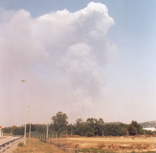
Click the image below and use right arrow until you reach the earth's surface. The latter three photos were taken from the surface on this day; one with several wild fires in Portugal. The photos show the development of a pyrocumulus cloud clearly. See how the dark smoke cloud grows vertically into a bright cumulus cloud!
Click to open gallery
Pyrocumulus definition
There is no official definition of pyrocumulus according to WMO. However, there are some definitions according to renowned meteorological institutions:
American Meteorological Society (AMS)
Pyrocumulus -
A cumulus cloud formed by a rising thermal from a fire, or enhanced by
buoyant plume emissions from an industrial combustion process.
MetOffice (UKMO)
Pyrocumulus - Cumulus
cloud that forms over an intense source of heat on the ground, such as
a heat of forest fire. (...) is an unhappy mixture of Greek and Latin.
Question
In which situations do you think smoke from fires may be retained in a certain tropospheric layer?
The correct answer is b).
In fact, when the atmosphere is stable, the risk for a dramatic growth of a pre-existing fire is low. However, due to the existence of an inversion layer, smoke is likely to be trapped below that layer. You will see an example in the next subchapter.
Smoke Spread within a Temperature Inversion
This happened on 4 August 2005 over Portugal - see Meteosat 8 HRV loop in Figure 4.2.
Fig 4.2 - Meteosat 8 RGB [HRV, HRV, IR10.8] animation over the Iberian Peninsula between 07:30 UTC and 13:15 UTC on 4 August 2005
The animation stops at 13:15 UTC. Can you guess what really happened afterwards?
Well, the fires kept on going during the afternoon, and later that day (around 5 hours after the last image of the animation of Figure 4.2) the sky became severely obscured by smoke and clouds as can be understood from the HRV image at 18:30 UTC (Figure 4.3).
On 4 August 2005, firefighting from the air (with airplanes and helicopters) had to be cancelled because of the drastic reduction in visibility. To confirm the existence of an inversion layer, please look at the tephigram from Lisbon at 12:00 UTC of that day (Figure 4.4).
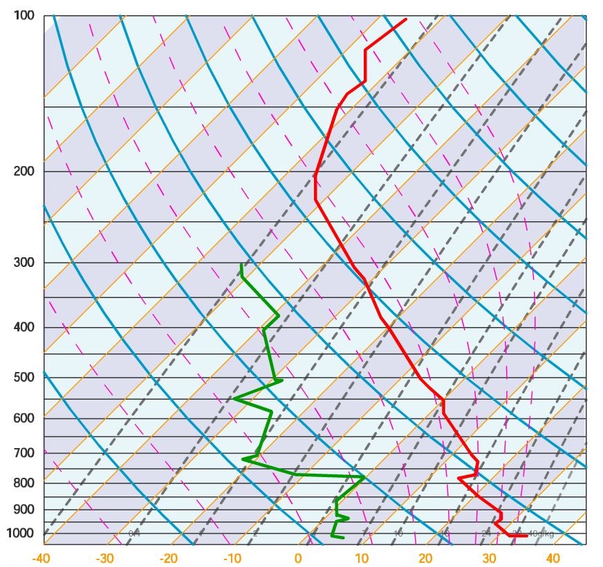
Fig 4.4 - Tephigram from Lisbon on 4 August 2005 at 12:00 UTC.
There are two inversion layers: one between 920 and 940 hPa (below 1000m) and another one between 760-770 hPa (around 2500m)!
The animation below is an imaginary scenario that will show you schematically what happens with smoke in combination with a radio sounding.
Fig 4.5 - Tephigram with temperature T (red) and dewpoint temperature Td (green).
We start from a stable situation with no remarkable inversion. In this situation the smoke slowly rises to the higher layers of the troposphere and dissolves.
As time progresses, an inversion settles around 700 hPa. As a consequence, the inversion functions like the lid on a boiling pan and ensures that the smoke is retained in the lower layers of the troposphere.

Summary and Exercises
As you have seen, there are a few specific concepts related to fire behaviour. Let's see if you have learned enough about fires to solve the following quiz!
Question
Connect the concept with its description.
Is defined as the rate of heat energy release per unit time per unit length of fire front. Also known as frontal fire intensity or line fire intensity.
What this final game illustrated was that fires may be classified according to different criteria depending on the purpose.
For instance, for fire combat purposes one may be interested in classifying the fire according to the level (crown, surface or ground), but it may be also relevant to evaluate the rate of spread or the forcing mechanism (wind or convection).
You also learned that pyrocumulus clouds may form and smoke may be retained within temperature inversion layers.