
Basic Satellite Course: Identify cloud types and their characteristics

The course aims to give an overview on the basics of satellite meteorology: image analysis i.e. the interpretation of patterns in satellite images that are related to various meteorological phenomena. The course is asynchronous, which means that you can take it at your own pace as all the lectures are pre-prepared.
Quizzes are made for you to check your level of understanding.
In this part of the course you will not only learn more about the identification of clouds such as Stratus, Cumulus and Cirrus from satellite images, and you will also discover various methods to derive cloud height information. Microphysical properties of clouds like cloud phase and cloud particle size are also addressed.
Note: all resources are provided as an external link which redirects you to https://eumetcal.eu where you will need to create a user account in order to gain access to the course. Once you register you can navigate through the modules inside the Moodle page.
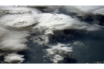
 Stratiform, cumuliform and cirriform cloud regions
Identify stratiform, cumuliform and cirriform cloud regions and individual cloud forms and their characteristics.
To access the resource click here.
 Cumulonimbus clouds
Identify cumulonimbus and their characteristics.
To access the resource click here.
 Fog and low cloud
Identify fogs and discriminate between fog and low cloud.
To access the resource click here.
 Contrails and ship trails
Identify contrails and ship trails.
To access the resource click here.
 Cloud top heights
Deduce cloud top heights based on brightness temperatures, surface observations and sounding data.
To access the resource click here.
 Clouds and particles
Identify clouds made of water droplets, ice particles or a mixture and discriminate between clouds with small or large cloud particles.
To access the resource click here.