Physical Basis
Which channels are useful for nighttime fog or low cloud detection?
At night only infrared (IR) channel data is available (IR10.8, IR12.0 and IR3.74). These are 'atmospheric window' channels where the absorption of the gas molecules is low. For cloud-free surfaces and opaque clouds, signal measurement in the atmospheric window channels depends mainly on the temperature of the measured object (sea, land, cloud top). The signal also depends on emissivity, as well as slightly on atmospheric effects. For semi-transparent clouds the interpretation of the measured radiation is more complicated.
The 'traditional' IR10.8 channel is included in the Night Microphysics RGB because it distinguishes thick clouds by their cloud top temperatures. However, for our purposes one channel is not enough.
Using only one IR channel makes the detection of two cloud types problematic:
- It is difficult (or impossible) to separate fog or low water clouds from a surrounding cloud-free surface because their temperatures are close to each other.
- It is difficult (or impossible) to separate semi-transparent clouds from opaque clouds.
These problems can be solved by analyzing the following brightness temperature differences:
- The (IR10.8-IR3.74) difference helps to distinguish water clouds (fogs) from cloud-free areas.
- The (IR12.0-IR10.8) difference helps to distinguish thick and thin clouds.
For that very reason these differences are used in the Night Microphysics RGB together with the IR10.8 channel.
Distinguishing between cloud-free surfaces and fog or water clouds
The (IR10.8-IR3.74) brightness temperature difference helps to distinguish water clouds (fogs) from cloud-free areas.
The technique is based on two facts:
- The emissivity values of water clouds and the surface are about the same in the IR10.8 channel. As a consequence, water clouds are hard to detect in IR10.8 images.
- The emissivity values of water clouds and the surface differ slightly in the IR3.74 channel. As a consequence, fog or stratus doesn't show up clearly in IR3.74 images either, though still a little better than in the IR10.8 channel.
The difference between water clouds and the surface will be more pronounced in the (IR10.8-IR3.74) difference image. The difference will be high for water clouds (or fog) and around zero for cloud-free surfaces.
Detection of semi-transparent cirrus clouds
Cirrus clouds consist of ice crystals and are often semi-transparent. In the case of thin clouds some of the radiation coming from below goes through and so the radiation reaching the satellite is called 'mixed radiation': the brightness temperature is usually higher than the real temperature of the cirrus clouds. The brightness temperature of a semi-transparent cloud depends primarily on its real temperature, its transparency and the temperature of the underlying surface.
For semi-transparent clouds the brightness temperature difference of two channels depends strongly on differences in transmissivity. The transparency of thin ice clouds is considerably different around 3.74, 10.8 and 12.0 micrometers, as the ice's absorption is rather different at these wavelengths (see the arrows in Fig. 1a). Thin cirrus clouds can be detected by the (IR12.0-IR10.8) and (IR10.8-IR3.74) differences (large negative differences). The absorption is weaker in the IR10.8 channel than in the IR12.0 channel, which means the IR10.8 transmissivity will be higher and as a consequence the (IR12.0-IR10.8) brightness temperature difference will be negative.
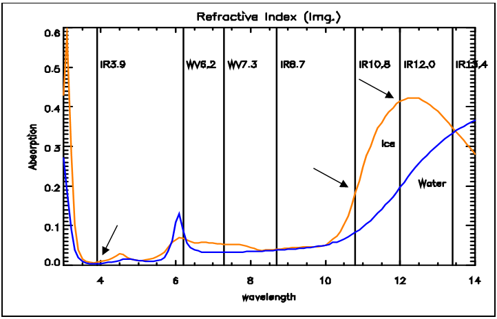
Figure 1a: Absorption spectra of water (blue curve) and ice (orange curve)
(Source: MSG Interpretation Guide, EUMETSAT)
Fig. 1b shows simulated (11-12 microns) brightness temperature difference (BTD) values as a function of 11 micron brightness temperature (BT) for different types of cirrus clouds. The black numbers along the curves refer to the cloud optical thickness. The figure shows that:
- The BTD values of opaque cirrus clouds are close to zero (left node of the curves).
- The BTD values of almost totally transparent and extremely thin cirrus clouds are also close to zero (right node of the curves).
- For medium thick semi-transparent cirrus clouds the 11 and 12 micron BTs differ considerably.
This is the difference which makes it possible to distinguish opaque and (not too thin) semi-transparent ice clouds.
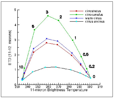
Figure 1b:Simulated BTD (11-12 microns) as a function of 11 micron BT for different types of cirrus clouds. The numbers refer to optical thickness
(Source: P. Menzel, NOAA NESDIS, Univ. of Wisconsin)