
white
High reaching opaque clouds appear white in the Airmass RGB images. Lower clouds turn into red, green or blue depending on the air mass they lay within.
Frontal cloud bands and convective cellls depict in white in the Airmass RGB image. Fronts are located at air mass boundaries. Depending on whether an opaque cloud lays in a polar air mass or a tropical airmass, the white colour can turn into bluish or greenish. If a dry layer lays atop a cloud, its colour can turn into a redish-white.
Due to the presence of water drops and high humidity in all levels, the brightness temperature difference (BTD) WV6.2-WV7.3, which determines the red colour beam, is small. The scale for the red colour beam is chosen this way, that small BTD lead to large contributions of the red colour.
The green contribution is also large. As the measured radiation stems from the upper troposphere (cloud tops), the BTD between the window channel IR10.8 and the ozone absorption channel IR9.7 is small.
Measured radiance in the WV6.2 channel is low because a large part of the surface emitted thermal radiation has been absorbed by the cloud droplets. As the temperature range for WV6.2 has been inverted, the colder the measured temperature, the higher the contribution of the blue colour beam.
All three colour beams contribute with the same high amplitude to the RGB image. Embedded convective cells are recognised only by their specific shape, and not by their specific colour. Frontal systems typically depict in white tones.

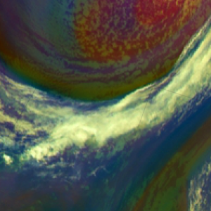
Explanation of the colour of high opaque clouds in the Airmass RGB (see also the recipe on the left side):
• For high opaque clouds, all 3 colour beams contribute strongly. Therefore the resulting colour is white.
• Low/mid level clouds with a dry troposphere atop turn into a whitish red (see image above - France).
• Low/mid level clouds within the polar air mass turn into a whitish blue (see image above - northern Germany).
• Low/mid level clouds within a tropical air mass turn into a whitish green (see image above - Serbia).
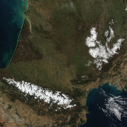
Snow and ice appears whitish in the VIIRS True Colour RGB images. Fresh, thick snow covering totally the surface appears white. Dirty snow, melting snow appear darker. Ice appears whitish, usually slightly darker than fresh, thick snow cover.
The images below show the snowy Pyrenees and the Caucasus Mountains with a cirrus cloud.
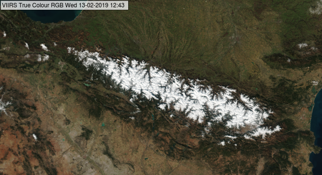
NPP, VIIRS True Colour RGB image for 13 February 2019, 12:43 UTC
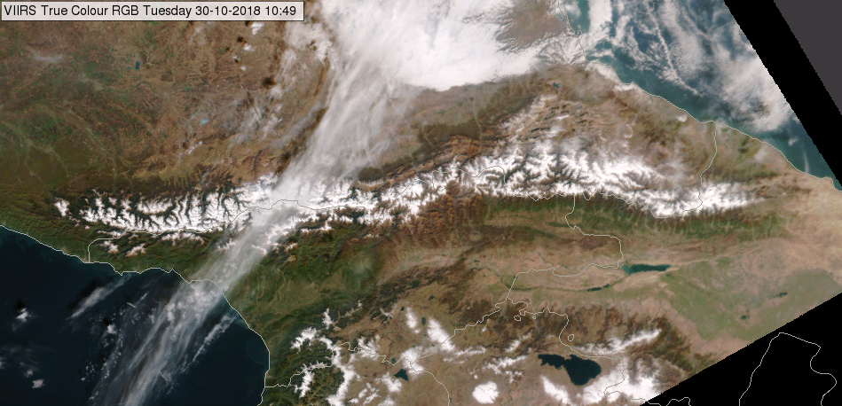
NPP, VIIRS True Colour RGB image for 30 October 2018, 10:49 UTC
Snow on lowland and on the Alps are presented by the True Colour and Natural Colour RGB images below. In the True Colour RGB it is much more difficult to detect the low clouds over snowy areas than in the Natural Colour RGBs.
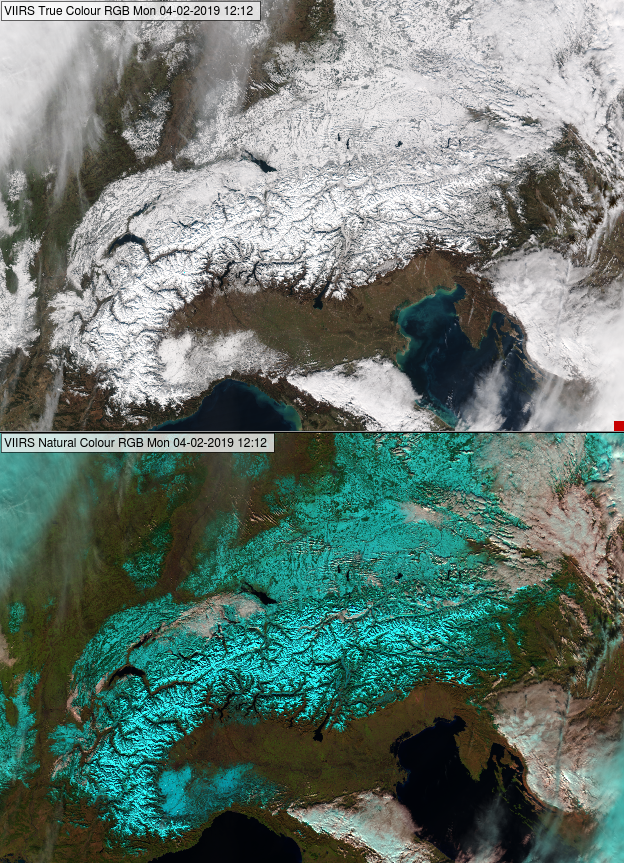
NPP, VIIRS True Colour RGB (top) and Natural Colour RGB (bottom) for 04 February 2018, 12:12 UTC
Cloud-free snowy mountains and lowland usually have different appearance in the satellite imagery. If the snow lies on a plain or low hill, one can often see patches, lines or spots. Patches might be due to forest with shadows and branches not covered by snow. Lines might be due to rivers, and spots (small patches) due to settlements. In mountainous terrain one can often see the structure of the valleys and ridges. Snow on high mountains is usually depicted in a brighter colour than on plains or hills, as there is less vegetation in the mountains to disrupt the snow cover.
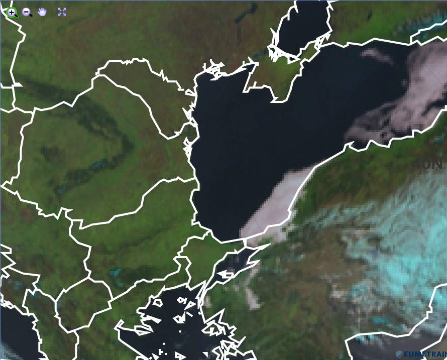
In the next image snow on low land and ice on the Great Lakes (border of US and Canada) are seen.
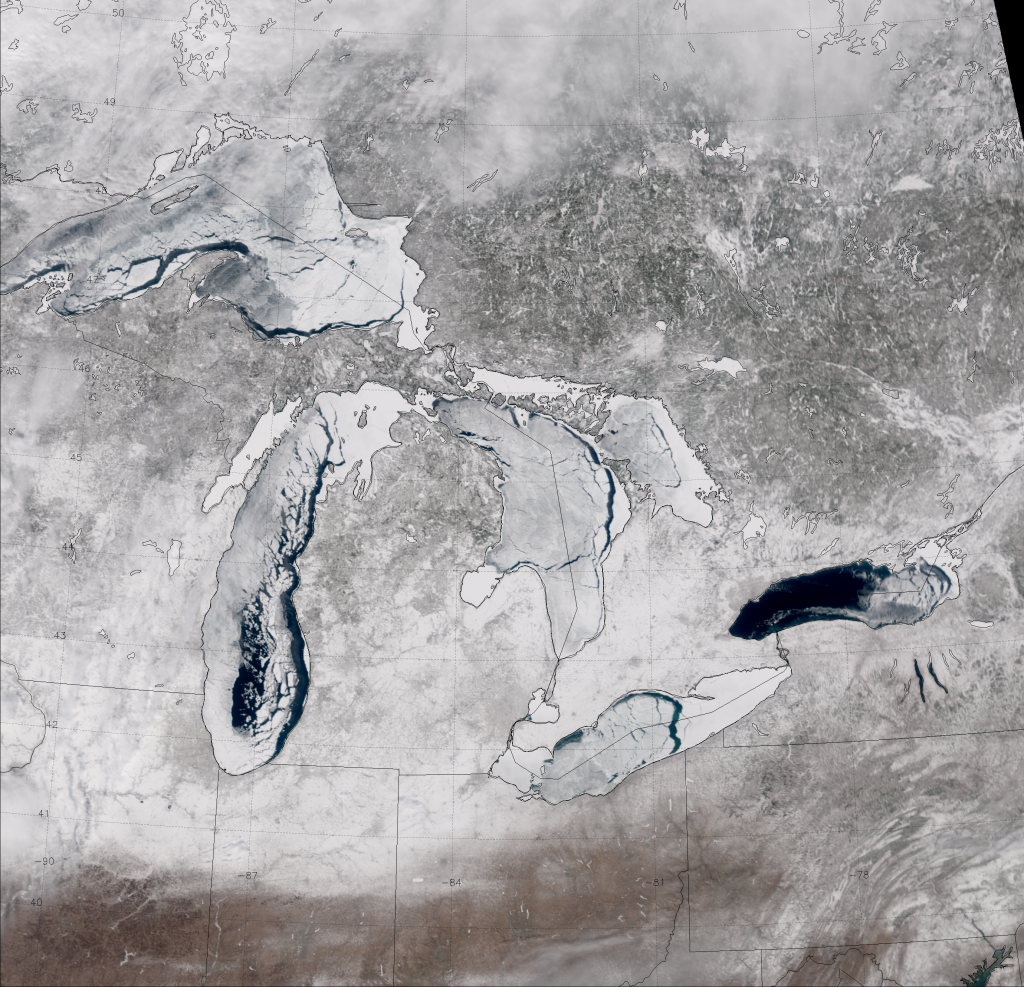
VIIRS True Color RGB for 6 March 2014, 18:35 UTC
(Source: http://rammb.cira.colostate.edu/projects/npp/blog/index.php/2014/02/)
Note that:
• The snow/ice colour depends not only on the snow/ice characteristics but as well as on the solar and satellite viewing directions. Towards the edge of the swath the whitish colour may become saturated white, while along the sub-satellite track it might be slightly darker.
• Thick clouds appear also whitish.
• Thin clouds and large concentration aerosol plume appear greyish.
Explanation of the colour of snow and ice in the True Colour RGB (see the recipe):
The reflectivity value of fresh, thick snow is high (close to 100 %) and about the same in all three visible channels and so it appears (almost) white in the True Colour RGB.
Dirty and/or melting snow may appear greyish, as its reflectivity is lower at the visible wavelengths.
Reflectivity of ice is slightly lower than reflectivity of fresh, thick snow.
Thick clouds usually appear white in the VIIRS True Colour RGB images. The images below show some examples.
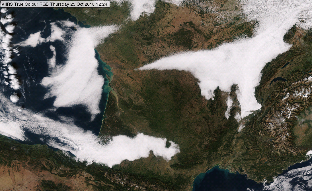
NPP, VIIRS True Colour RGB image for 25 October 2018, 12:24 UTC
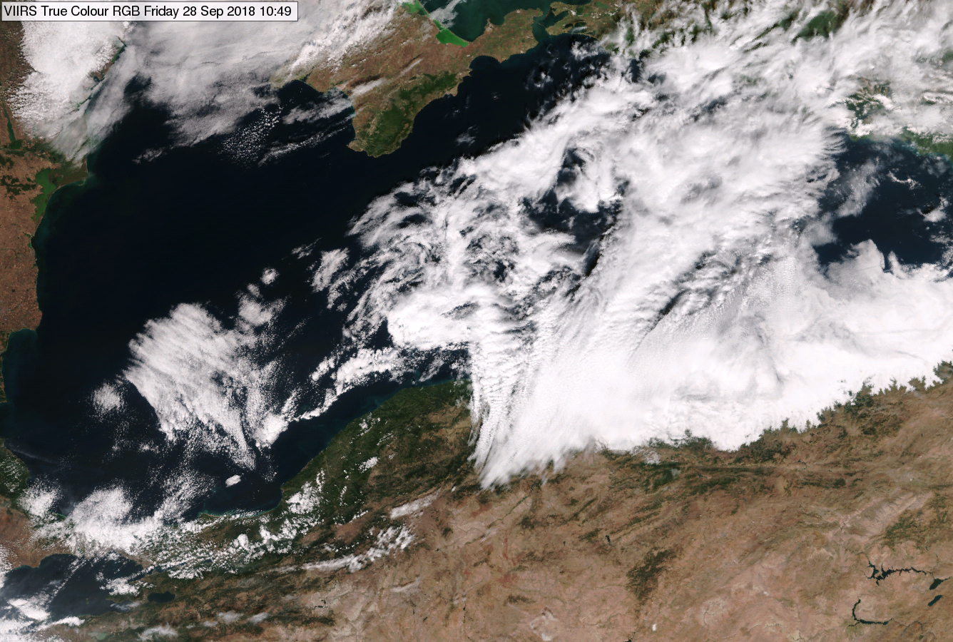
NPP, VIIRS True Colour RGB image for 28 September 2018, 10:49 UTC
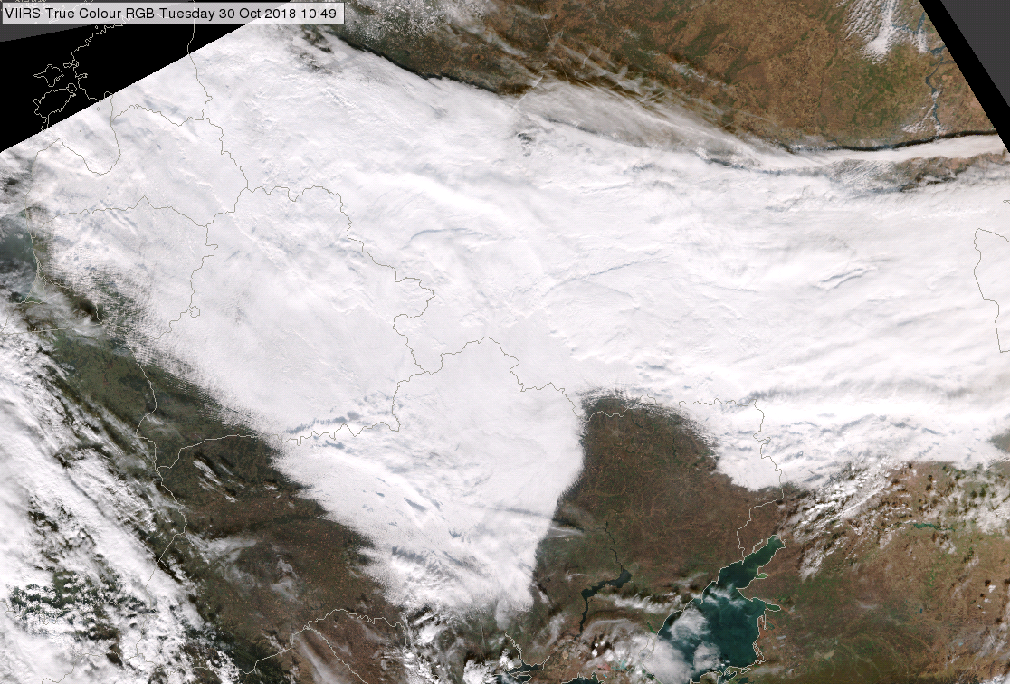
NPP, VIIRS True Colour RGB image for 30 October 2018, 10:49 UTC
Note that:
• The colour brightness depends not only on the cloud characteristics but as well as on the solar and satellite viewing directions. Towards the edge of the swath the whitish colour may be saturated white, while along the sub-satellite track it might be slightly darker.
• Snow and ice appear also white.
• Thin clouds and high concentration aerosol plumes appear greyish.
Explanation of the colour of thick clouds in the True Colour RGB (see the recipe):
The cloud elements strongly scatter the visible radiation and the absorption of visible radiation within the cloud is very low. For thick clouds the reflectivity values are high (close to 100 %) and similar in the tree visible channels. As a consequence, thick clouds appear (almost) white in the True Colour RGB.
Mid-level water clouds appear white in the HRV Cloud RGB images.
Water droplets and ice crystals strongly reflect short wave solar radiation in case of an opaque cloud, hence the strong intensity of the red and green colour beam. The blue colour contribution from the window channel IR10.8 has about the same intensity for mid-level clouds than the contribution from HRV. The warmer the cloud, the more yellowish its colour will be, the colder, the stronger the blue component.
For mid-level clouds, both channels (HRV and IR10.8) have about the same intensity, the resulting colour is a whitish grey. The HRV Cloud RGB image below shows mid-level cloudiness over north-western France.
HRV Cloud RGB from 17 July 2015, 12:00 UTC
Sometimes, the HRV channel of the HRV Cloud RGB is enhanced by a sun angle correction. This leads to higher intensities in the HRV reflectivities, especially at low sun angles during the winter months. As a consequence, warmer water clouds look more yellowish in the HRV Cloud RGB in winter then in summer.
Explanation of the white colour of mid-level clouds in the HRV Cloud RGB (see the recipe):
• Both channels (HRV and IR10.8) contribute with the same intensity to the HRV Cloud RGB, the resulting colour is white.
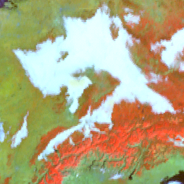
Fog and water clouds with small droplets on the cloud top appear white in the Snow RGB images.
The images below show situations when fog and/or low clouds formed over the snow covered surface. The valley fog or stratus clouds are nicely seen in the Alps due to the good colour contrast between the red-orange snow and the white water clouds.
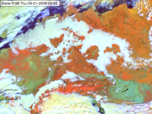
Meteosat, SEVIRI Snow RGB, 08 January 2009, 09:55 UTC
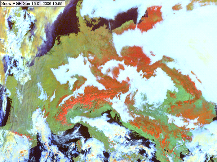
Meteosat, SEVIRI Snow RGB for 15 January 2006 10:55 UTC
Continental fog and low level water clouds usually consist of small droplets. Note that water clouds with large droplets on their top appear not white, but light yellow in the Snow RGB images.
Explanation of the colours for fog and water clouds consisting of small droplets (see the recipe):
• The reflectivity values of water clouds are high in the VIS0.8 channel, lower in the NIR1.6 channel and even lower at 3.9 micrometer channel. However, after the linear stretching and the gamma correction the signal will be very high in all three colour beams. The green signal is often saturated; the blue signal is also often close to the maximum. As a consequence water clouds with small droplets appear (close to) white in the Snow RGB images.

Thick ice clouds are whitish in the Cloud RGB images, because their reflectivity values are high and close to each other in the 0.63 and 0.87 micron channels, while their cloud top temperature is low. As the 10.8 micron channel is inverted in this RGB, cold temperature means intense signal in the blue colour beam. See the recipe.
The images below show deep convective clouds over the coast of Italy and Spain and over Bulgaria. One can see the cloud top features due to the shadows: e,g, overshooting tops, gravity waves. In the shadows we see darker (grayish) shades.
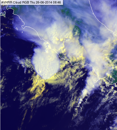
MetOp AVHRR Clouds RGB image, 26 June 2014, 08:46 UTC
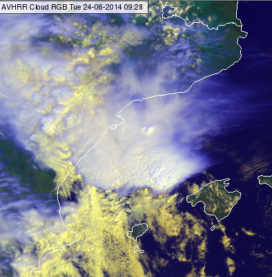
MetOp AVHRR Clouds RGB image, 24 June 2014, 09:28 UTC
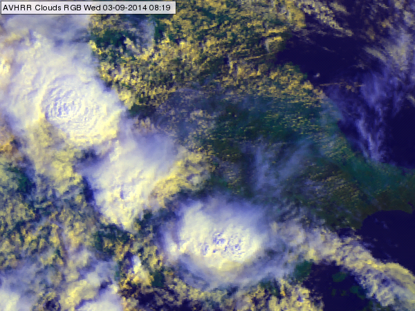
MetOp AVHRR Clouds RGB image, 03 September 2014, 08:19 UTC
Water clouds are whitish in the Natural RGB images, because their reflectivity values are high and close to each other in the 0.63, 0.87 and 1.6 micron channels.
The image below (MetOp AVHRR Natural Colour RGB image from 08 March 2014 10:06 UTC) shows the Strait of Gibraltar with the Mediterranean Sea to the East, and the Atlantic Ocean to the West. The low level wind was easterly. The region was mainly cloud free except a cumulus cloud band elongated from the strait to the East. In this band low level cumulus clouds formed due to the orographic forced convergence and lifting. West from the strait the clouds disappeared.
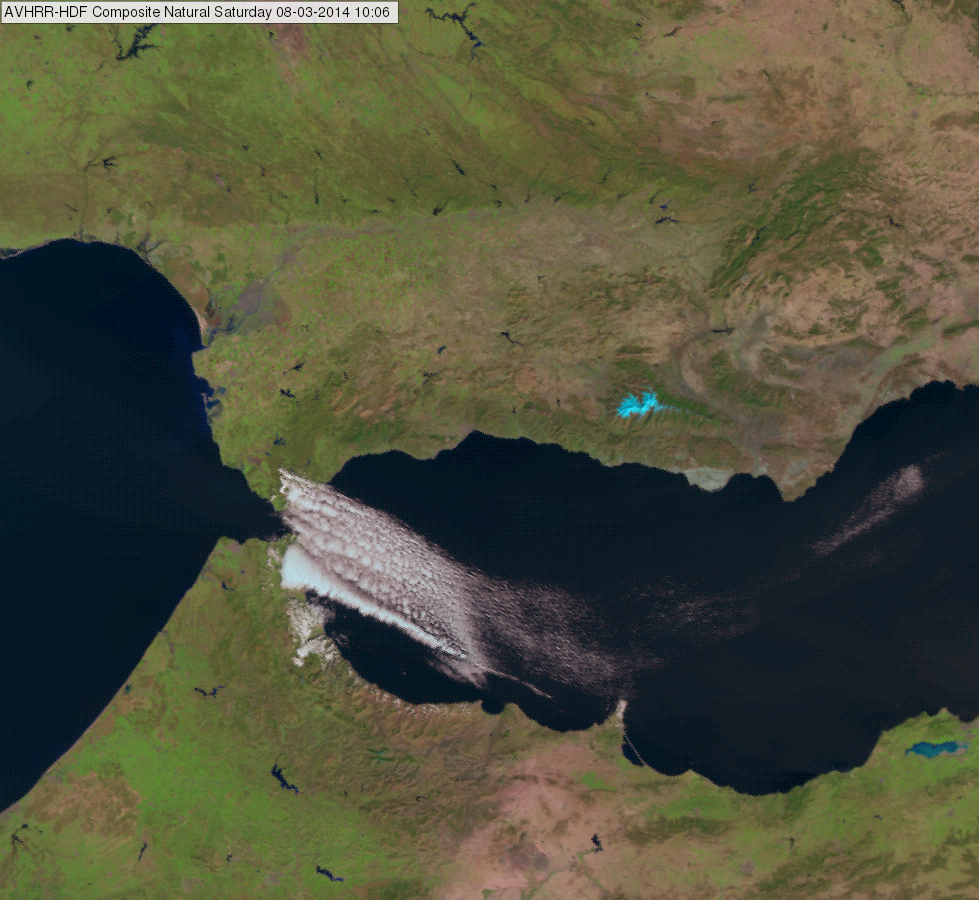
MetOp AVHRR Natural Colour RGB image from 08 March 2014 10:06 UTC
Explanation of the white tone of low-level water clouds in the Natural Colour RGB (see the recipe):
• With an equal contribution of the red, green and the blue colour beam over low-level water clouds, the resulting colour is white.

High reaching opaque clouds appear white in the Airmass RGB images. Lower clouds turn into red, green or blue depending on the air mass they lay within.
Frontal cloud bands and convective cellls depict in white in the Airmass RGB image. Fronts are located at air mass boundaries. Depending on whether an opaque cloud lays in a polar air mass or a tropical airmass, the white colour can turn into bluish or greenish. If a dry layer lays atop a cloud, its colour can turn into a redish-white.
Due to the presence of water drops and high humidity in all levels, the brightness temperature difference (BTD) WV6.2-WV7.3, which determines the red colour beam, is small. The scale for the red colour beam is chosen this way, that small BTD lead to large contributions of the red colour.
The green contribution is also large. As the measured radiation stems from the upper troposphere (cloud tops), the BTD between the window channel IR10.8 and the ozone absorption channel IR9.7 is small.
Measured radiance in the WV6.2 channel is low because a large part of the surface emitted thermal radiation has been absorbed by the cloud droplets. As the temperature range for WV6.2 has been inverted, the colder the measured temperature, the higher the contribution of the blue colour beam.
All three colour beams contribute with the same high amplitude to the RGB image. Embedded convective cells are recognised only by their specific shape, and not by their specific colour. Frontal systems typically depict in white tones.
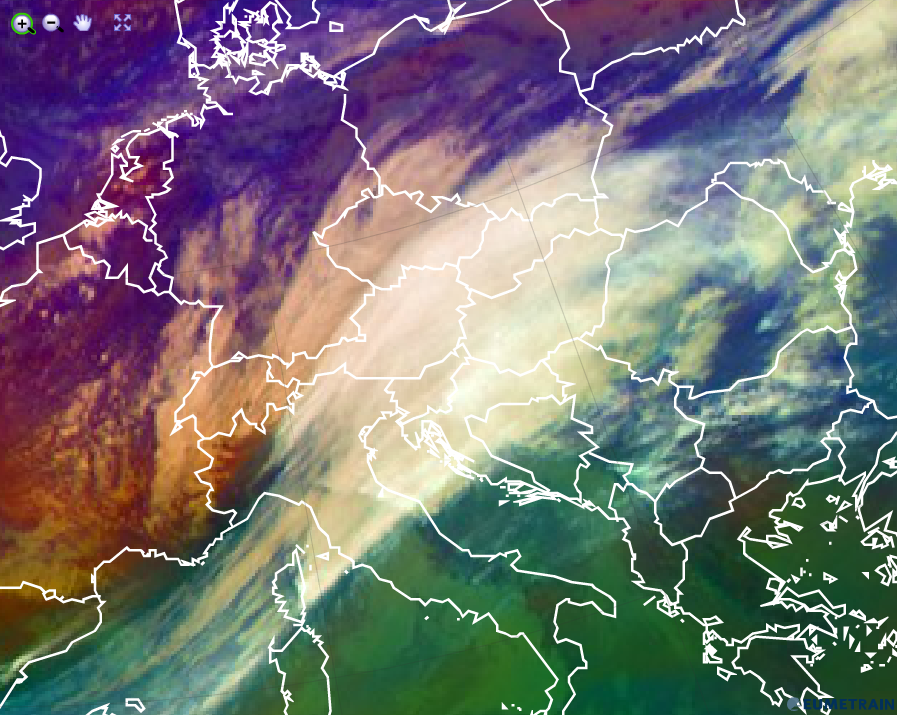
Airmass RGB for 3 Febuary 2016 12:00 UTC
Explanation of the colour of high opaque clouds in the Airmass RGB (see also the recipe on the left side):
• For high opaque clouds, all 3 colour beams contribute strongly. Therefore the resulting colour is white.
• Low/mid level clouds with a dry troposphere atop turn into a whitish red (see image above - France).
• Low/mid level clouds within the polar air mass turn into a whitish blue (see image above - northern Germany).
• Low/mid level clouds within a tropical air mass turn into a whitish green (see image above - Serbia).
Warm water clouds appear white in the Natural Colour RGB images.
Low and optically thick water clouds appear whithish in the Natural Colour RGB because the mesured reflected short wave radiation at 0.6, 0.8 and 1.6 micrometer are nearly equal. The image below shows fog patches over the black sea.
Natural Colour RGB for 30 April 2012 06:00 UTC
Very low and thin water clouds tend to have a more redish tone because the green and the blue colour beam from the visible channels at 0.6 and 0.8 micrometer decrease in intensity (see image below, Mediterranean Sea around Sicily). The reflection of short wave solar radiation in both visible channels correlates with the optical thickness of the cloud.
Natural Colour RGB for 29 January 2016 12:00 UTC
When ice crystals form at the top of the water clouds solar radiation at 1.6 micrometer is absorbed by ice and the intensity of the red colour beam decreases. Ice cystals do not affect the amount of refelcted solar radiation at 0.6 and 0.8 micrometer, water clouds mixed with ice crystalls are therefore overlayed by a cyan veil (upper left part of the above image).
Explanation of the colours of warm water clouds in the Natural Colour RGB (see the recipe):
• For optically thick warm water clouds, reflected solar radiation measured in all 3 channels is about the same. The resulting colour is white, sometimes grey depending on the solar angle.
• For optically thin warm water clouds, reflected solar radiation in channel 3 (1.6 micrometer) outbalances the measured radiance in the visible channels (0.6 and 0.8 micrometer). The resulting colour is reddish.
• Mixed ice-water clouds appear with a cyan veil above the white cloud feature. Similar to pure ice clouds, the solar radiation at 1.6 micrometer is absorbed by ice crystals (only slightly because of the fewer ice crystals), resulting in a reduction of the red colour beam.