
Atmospheric Composition
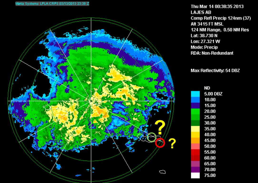
Diamantino Henriques gives a weather briefing for the Azores and looks back to the heavy rain event on 13th and 14th March 2013.
Length: 30 min
Author: Diamantino Henriques
Diamantino Henriques, received his degree in Atmospheric Physics at the University of Aveiro (1986) and his MS in Meteorology from the University of Lisboa (1996). From 1987 to 2003 he worked in Lisbon as meteorologist on atmospheric ozone and UV radiation issues. He has represented Portugal on several international meetings related with atmospheric composition and has participated in several projects and programs related with atmospheric ozone (GAW), atmospheric pollutants transport (EMEP) and UV radiation (EDUCE). In 2003 he moves to the Azores and worked at Ponta Delgada Airport as a senior meteorologist and forecaster. Later in 2008 he was nominated Head of the Regional Delegation of the Portuguese Institute of Meteorology (IM) in the Azores. Currently, he is the Head of the Azores Regional Delegation of the Portuguese Sea and Atmosphere Institute (IPMA, former IM) that includes the weather forecast service for the Azores.
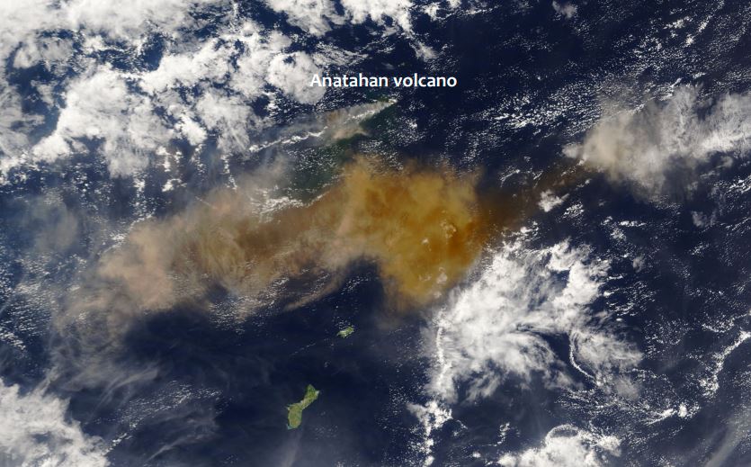
This module provides a guideline on how to assess the threat of volcanic ash. Therefore several tools based on satellite data can be consulted. Prominent examples are the Ash RGB or the use of IASI data.
Extreme weather conditions such the presence of volcanic ash can put aircraft navigation into major difficulties. If an aircraft encounters volcanic ash the navigation gets extremely challenging. Between 1975 and 1994 more than 80 jet airplanes were damaged due to unplanned encounters with clouds of volcanic ash. Seven of these encounters caused in-flight loss of jet engine power, putting the passengers lives at severe risk. Therefore the correct assessment of the weather conditions is essential to ensure save flight conditions. This training module is dedicated to forecasters/aviation forecasters. The main intention is to provide a guideline on how to assess the potential of hazardous weather events such as volcanic ash. For this purpose several tools based on satellite data can be consulted.
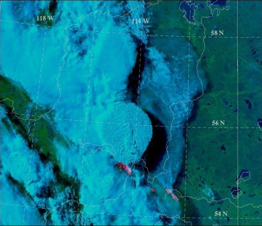
Training module on the detection of dust storms over Europe with various RGB images and products.
Atmospheric dust storms are common in many of the world's semi-arid and arid regions and can impact local, regional, and even global weather, agriculture, public health, transportation, industry, and ocean health. This globally-relevant three-hour module takes a multifaceted approach to studying atmospheric dust storms. The first chapter examines the impacts of dust storms, the physical processes involved in their life cycle, their source regions, and their climatology. The second chapter explores satellite products (notably dust RGBs) and dust models that are used for dust detection and monitoring. It also presents a process for forecasting dust storms. The third and final chapter of the module examines the major types of dust storms: those that are synoptically forced, such as pre- and post-frontal dust storms and those induced by large-scale trade winds; and those caused by mesoscale systems, such as downslope winds, gap flow, convection, and inversion downburst storms.
This training module was produced by COMET with the sponshorship and contribution of EUMETSAT and EUMeTrain.
The purpose of this training module is to give an overview on the different RGB types created from the AVHRR instrument.
This training module describes MetOp AVHRR (Advanced Very High Resolution Radiometer) RGB schemes that are based on EUMETSAT recommendations. The 'recipes' were tuned to create high quality MetOp/AVHRR RGB images as similar as possible to the SEVIRI RGB schemes recommended by EUMETSAT.
The main aim of the training module is to help the users (weather forecasters and/or other experts) understand and use these RGB types by giving them background information, examples and exercises.
The module takes the following structure:
- The aim of the RGB type
- Physical background
- How to create the given RGB type
- Typical colors
- Examples of interpretation
- Benefits and limitations
- Comparisons with other RGB types and/or single channel images
- Exercise
Fred Prata presents a series of volcanic eruption and analyses them from the satellite perspective.
Length: 65 min
Author: Fred Prata (AIRES Pty Ltd)
Since the late 1970's earth-orbiting satellites have been able to observe the weather around the globe and provide quantitative information on cloud movements. These data have proved extremely valuable for tracking volcanic ash clouds and more recently allowing quantitative information on volcanic ash column amounts and also on SO2 gas - another potential hazard to aviation. Notable incidents between commercial aviation and ash clouds, several in Indonesia and Alaska, have occurred during the satellite era (~1960's onwards). The talk will cover methods used to identify, quantify and monitor volcanic ash clouds and frame this in the context of the potential hazard.
Presentation 1 of the Environment Event Week 2016
Length: 30 min
Author: Oleg Dubovik (University of Lille)
The GRASP (Generalized Retrieval of Aerosol and Surface Properties) algorithm has been developed for enhanced characterization of the properties of both aerosol and land surface from diverse remote sensing observations. The overall concept of the algorithm is described by Dubovik et al. (2014), while the detailed are given in the paper is by Dubovik et al. (2011). The algorithm is based on highly advanced statistically optimized fitting implemented as Multi-Term Least Square minimization (Dubovik, 2004) and deduces nearly 50 unknowns for each observed site. The algorithm derives a set of aerosol parameters similar to that derived by AERONET including detailed particle size distribution, the spectral dependence on the complex index of refraction and the fraction of non-spherical particles. The algorithm uses detailed aerosol and surface models and fully accounts for all multiple interactions of scattered solar light with aerosol, gases and the underlying surface. All calculations are done on-line without using traditional look-up tables. In addition, the algorithm can use the new multi-pixel concept - a simultaneous fitting of a large group of pixels with additional constraints limiting the time variability of surface properties and spatial variability of aerosol properties. This principle provides a possibility to improve retrieval for multiple observations even if the observations are not exactly co-incident or co-located. Significant efforts have been spent for optimization and speedup of the GRASP computer routine and retrievals from satellite observations. For example, the routine has been adapted for running at GPGPUs accelerators. GRASP inherits many aspects used in AERONET retrieval. At first GRASP has been developed for POLDER/PARASOL multi-viewing imager and later adapted to a number of other satellite sensors such as METEOSAT/MERIS at polar-orbiting platform and COCI/GOMS geostationary observations. It can be equally applied to ground-based AERONET and lidar observations. The results of numerical tests and results of applications to real data will be presented.
Presentation 2 the Environment Event Week 2016
Length: 30 min
Author: Rudiger Lang (EUMETSAT)
The monitoring of trace-gases, pollution and aerosols is important both for the quality of current and future weather forecast model output, as well as for the direct monitoring of aircraft safety, pollution levels, and other health related issues. Satellite instruments on-board EUMETSATs operational platforms, like on the Low-Earth Orbit (LEO) Metop platform, or the Geostationary Orbit (GEO) MSG platform, and their future successors EPS-SG and MTG, provide unique long-term monitoring capabilities of atmospheric composition addressing many of these issues. We will introduce the capabilities of instruments on these platform to retrieve trace-gases from ozone to nitrogen dioxide, CO and of greenhouse gases like methane, as well as their capability to retrieve aerosol optical and microphysical properties including volcanic ash. We will provide examples on how these products are used in current and future versions of numerical forecast models which include atmospheric chemistry processes, like in the model provided by the Copernicus Atmospheric Monitoring Service (CAMS).
Presentation 3 the Environment Event Week 2016
Length: 30 min
Author: Tommi Bergman (FMI)
The aerosols have recently been incorporated into increasing number of global climate models. Aerosol models in global climate models are validated using variety of ground-based observations and satellite retrievals. Both data have their own advantages and disadvantages. For example, in-situ observations of particle size and composition give exact information on the aerosol distribution for small regions on the ground while satellite retrievals give a broader view on the global distribution of aerosols. In both cases the rather coarse spatial and temporal resolution of the global models increase the difficulty of using these data for their validation. I will demonstrate the limitations of the satellite retrievals and in-situ observations when comparing with models and demonstrate how, for example, collocation of the data can help to improve the match between models and observations.

Presentation 5 in the Environment Event Week 2016
Length: 30 min
Author: Helen Worden (NCAR, Boulder)
Measurements Of Pollution In The Troposphere (MOPITT) on the NASA Terra spacecraft has been measuring the global atmospheric abundance of carbon monoxide (CO) since March 2000. Carbon Monoxide is mainly produced by incomplete combustion from both natural fires and anthropogenic activities and is also a product of chemical reactions with other air pollutants. These pollution sources have a large effect on both local and downwind air quality, as well as climate change. We will show how satellite measurements of carbon monoxide are used to understand how pollution is emitted and transported globally, from large scale fires to urban sources.
Presentation 6 in the Environment Event Week 2016
Length: 30 min
Author: Mike Fromm (NRL)
Pyroconvection is not a new concept. However, the idea that pyroconvection can be explosive enough to inject a smoke plume into the stratosphere that pollutes hemispherically, goes against the grain of textbook atmospheric physics. Since the discovery of forest fire smoke in the stratosphere, skepticism has given way to acceptance, understanding, excitement, and wonder. That is because pyrocumulonimbus (pyroCb for short) research continues to make more discoveries, involve growing collaborations, and invite new questions.
This presentation will be an overview of pyroCb research. It will focus on observations from satellite sensors. Emphasis will be on platforms such as MODIS, AVHRR, GOES, TOMS, OMI, GOME 2, and CALIPSO. Also to be explored will be the curious historic connection between pyroCb and volcanic eruptions.
Presentation 7 in the Environment Event Week 2016
Length: 50 min
Author: Mike Willmott (BOM)
Apart from the central desert areas, the Australian landscape, from the tropics of Far North Queensland to the southern tip of Tasmania has climatic conditions and vegetation which are conducive to wildfires throughout the year. The most volatile of these areas being the south eastern parts of Australia which includes the states of South Australia, Victoria, New South Wales and Tasmania. Australia has large tracts of wilderness which can only be monitored by aircraft and satellite and as such, remote sensing for bushfires within the landscape is virtually mandatory throughout the dry season in the tropics and the summer periods for the southern states. This talk looks at some of the ways that Satellite Remote Sensing has assisted emergency managers for preparedness, response and recovery, the three most important factors for any emergency operation.
Presentation 8 in the Environment Event Week 2016
Length: 30 min
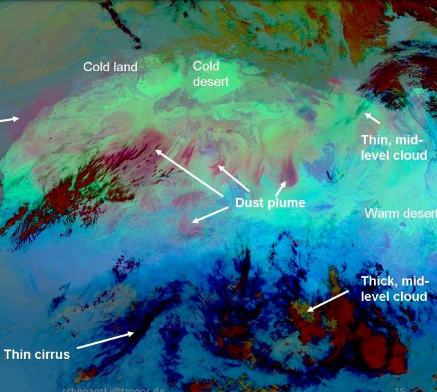
Author: Kerstin Schepanski (TROPOS)
Dust sources are mostly located in remote areas and satellite observations are very suitable for their identification. Different methods inferring active dust sources have been developed in the recent past, which roughly can be separated into direct (e.g., back-tracking of dust plumes to their place of origin) and indirect methods (e.g., frequency of high atmospheric dust loading). Thereby, the accuracy of the identification methods varies with the temporal and spatial resolutions and the ambiguities of the satellite dust retrieval used. In concert with satellite-based dust source characterization, model simulations allow for a holistic assessment on dust sources and their controlling mechanism - ultimately providing insight into the multifaceted nature of the atmospheric dust life-cycle.