Chapter III: The Mesoscale Convective System
Table of Contents
- Chapter I: The Mesoscale Convective System
- Introduction
- Before the MCS
- During the MCS
- After the MCS
The Mesoscale Convective System
If one analyzes the convective activity around the island one can identify the formation of an organized convective system at 6-7 UTC to the southwest of the island (Figure 8). This system (that included individual cells as referred above) moved towards the island, being over land between 10 and 12:30 UTC and dissipating after 13 UTC. Therefore, from the 6 to 7 hours of its activity, 2.5 h happened over Madeira Island.
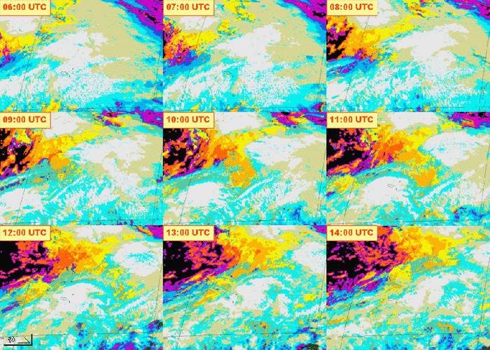
Figure 8: Cloud type product from meteosat 9 on 20/06/2010, from 06:00 to 14:00 UTC (every hour).
Regarding the extension of the system, the area of cloud top temperature below -35°C extends for around 350 km in the axis of maximum extent (Figure 9). This fits the criteria for a mesoscale convective system (MCS) which, for oval-like systems, sets a threshold of 200 km for the maximum extension of the area with cloud top temperature below -32°C (eg, AEMET, 1999). Despite there is no known climatology of MCS over this region of the North Atlantic, the time length of this system is in line with the 5.5 hours duration that Morel and Senesi (2002) found for an average MCS detected by satellite in Europe.
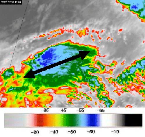
Figure 9: Meteosat 9 Infrared 10.8 on 20/02/2010 at 11 UTC, overlaid with two-end arrow for MCS extension.
Before the MCS
Before 10 UTC, precipitation was not related to the MCS, but at some instants some heavy convective precipitation could be identified (Figure 10). Namely at 06:00 and 07:45 UTC maximum values of Convective Rainfall Rate (CRR) between 10 and 20 mm/h exist over the island. The highest amounts of AWS precipitation in Funchal (between 9 and 10 UTC) are not particularly related to high CRR values, suggesting heavy precipitation with lower cloud tops, accounting for high precipitation efficiency. To be noted also is that maximum values apparently tend to exist over the island (and not so much in the surrounding), suggesting here a signature for orographic intensification.

Figure 10: Convective Rainfall Rate (CRR, in mm/h) from Meteosat 9 at some instants between 06:00 and 10:15 UTC on 20/02/2010.
During the MCS
The analysis of the MCS by satellite imagery between 10 and 12:30 UTC, also suggest strong activity to the west and northwest of the island, where rain could not naturally be measured at the surface. Beside the information from severe storm RGB referred above (Figure 6), the difference between WV6.2 and IR10.8 channels provide an indication of possible overshootings over the ocean (in yellow and red in Figures 11 and 13, at 10:15 and 11 UTC, respectively). It should be noted though, that the High Resolution Visible (HRV) does not show such an irregular topography of cloud tops as very often can be detected with lower solar angles as in this case (Figure 12, at 10:15UTC). It also should be stressed that the suggested area of overshootings is not related to the highest amounts of CRR, which is a derived product and believed to be more informative (Figure 14, at 11:00 UTC).

Figure 11: Meteosat 9 Difference WV6.2 - IR 10.8 on 20/02/2010 at 10:15 UTC. Positive values in yellow and red, depicting overshooting tops.

Figure 12: Meteosat 9 High Resolution Visible on 20/02/2010 at 10:15 UTC.

Figure 13: Meteosat 9 Difference WV6.2 - IR 10.8 on 20/02/2010 at 11 UTC. Positive values in yellow and red, depicting overshooting tops.

Figure 14: Meteosat 9 Convective Rainfall Rate (CRR, in mm/h) from Meteosat 9 on 20/02/2010 at 11:00 UTC.
After the MCS
After the MCS left the island of Madeira, there were still relative maxima of CRR over the island at 12:45, 13:15 and 14:00 UTC, again suggesting orographic influence on the precipitation regime (Figure 15). In this period the mountain station of Areeiro is still having precipitation between 5 and 10 mm in 10 minutes, therefore, still loading water into the (already overloaded) channeled rivers that flow to city of Funchal.

Figure 15: Convective Rainfall Rate (CRR, in mm/h) from Meteosat 9 at some instants between 12:30 and 14:00 UTC on 20/02/2010.