Introduction
During early morning and morning on 20th February 2010 an extreme and rare flash flood event has occurred in the Portuguese island of Madeira in the North Atlantic, causing 42 casualties, 600 homeless and an estimated loss of around 1000 million euros.
In the coastal city of Funchal an amount of 111.5 mm (05:10-11:10 UTC) occurred in a 6-hour period (with a 24h amount of 144.3 mm). Higher amounts were recorded in the mountainous weather station Pico do Areeiro, at 1510 meters, with a 6-hour peak of 272.1 mm (08:50-14:50UTC). This mountain area is right upstream of Funchal, therefore, the precipitation in the mountain simply flowed downslope along rivers that are usually small, summing up to an already high amount of water in lower altitudes. A precipitation time-lag between Funchal and Areeiro is clearly depicted in the temporal evolution of 10 minutes precipitation (Figure 1). Note values in excess of 10 mm/10 minutes in Funchal and 15mm/10 minutes in Areeiro during the most intense time periods. The Portuguese met. service followed this extreme event issuing gradually higher levels of precipitation warnings since the day before: yellow warning at 19:27 UTC on 19th, orange warning at 08:53 UTC on the 20th and red warning one hour later, at 10:03 UTC.
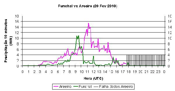
Figure 1: 10 minute precipitation in Funchal and Areeiro weather stations on 20th February 2010. After 17:30 UTC no data was recorded in Areeiro due to cut in the energy supply of the station during morning as a consequence of the devastation on the island (vertical black lines).