Benefits and limitations
The benefits of the Night Microphysics RGB
- At low and mid-latitudes the Night Microphysics RGB provides the best nighttime colour contrast between water clouds and the surface.
- Provides full cloud analysis at night.
- In some special conditions it provides nighttime snow detection - only if the temperature is very low and the snow is deep enough to cover completely the vegetation.
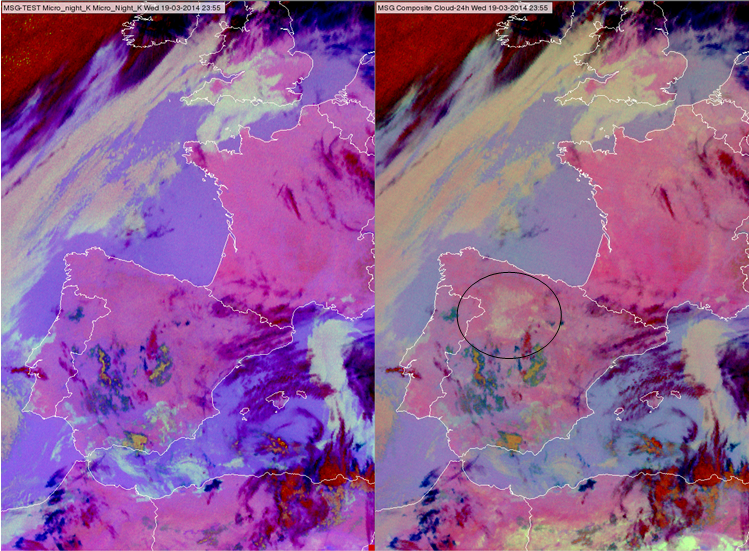
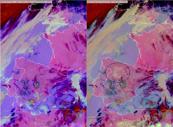
At low and mid-latitudes the Night Microphysics RGB provides the best nighttime colour contrast between water clouds and the surface. The 24 hour Microphysics RGB is also used for the same purpose. The big advantage of 24 hour Microphysics is that it is usable throughout the day, not just nighttime. However, the contrast between the surface and water clouds is less pronounced in the 24 hour Microphysics RGB images. Figs. 9a and b show comparisons between Night Microphysics and 24 hour Microphysics RGB images. Another limitation of the 24 hour Microphysics RGB is that the colour of bare soil (or desert) is close to the colour of the water clouds, see the encircled area in Fig 9a. Such bare soil area might be interpreted as low cloud in the 24 hour Microphysics RGB, but not in the Night Microphysics RGB. Note that at high latitudes the 24 hour Microphysics RGB is more useful.
|
Figure 9a: Night Microphysics RGB (left) and 24 hour Microphysics RGB (right) for 19 March 2014 at 23:55 UTC
|
|
|
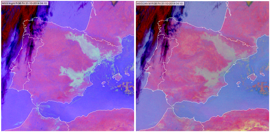
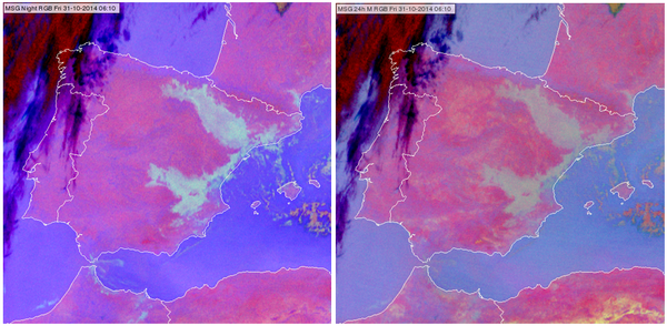
Figure 9b: Night Microphysics RGB (left) and 24 hour Microphysics RGB (right) for 31 October 2014 at 06:10 UTC
|
|
The fog formation on the Iberian Peninsula shown in Fig. 9b can be follow in Animation 2.
|
Animation 2: Time sequence of fog formation on the Iberian Peninsula created from Night Microphysics RGB images (30 October 2014 22:10 - 31 October 2014 07:10 UTC)
|
|
|
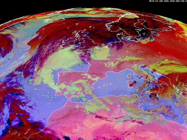
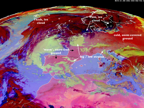
There is little to no information in IR images to help detect snow, unless it is very cold and vegetation is completely covered by a thick layer of snow. Fig. 10 shows an example for nighttime snow detection. The intense red colour in Eastern Europe indicates cold, snow-covered surfaces, while the pink colour in Western Europe indicates warmer, snow-free surfaces. This intense red colour is a combined effect of lower surface temperature (less blue) and lower (IR10.8-IR3.9) brightness temperature difference (less green) of the cold, snow-covered ground. The (IR10.8-IR3.9) brightness temperature difference depends on the emissivity of the ground at these two wavelengths. This night the minimum temperatures on these areas were below -20 °C.
Limitations
- If there are thin, semitransparent cirrus clouds above water clouds, the Night Microphysics RGB might not detect the water clouds
- Extremely thin water cloud or fog might not be detected by the Night Microphysics RGB.
The IR3.9 channel is the key channel in the nighttime fog/low cloud detection. However, it causes also several problems in case the IR3.9 channel contains solar radiation
- The Night Microphysics RGB is not usable at daytime
- The solar radiation causes problems in low cloud detection at dawn /dusk as well.
- Around solar equinox the IR3.9 channel may contain some solar radiation around midnight, spoiling this RGB at some area.
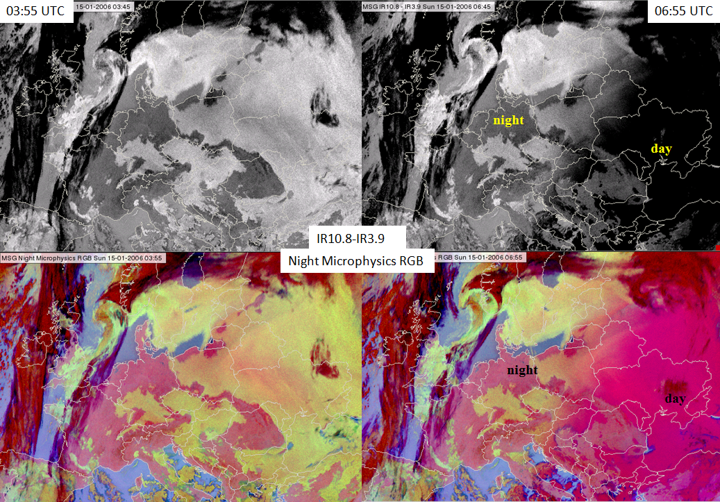
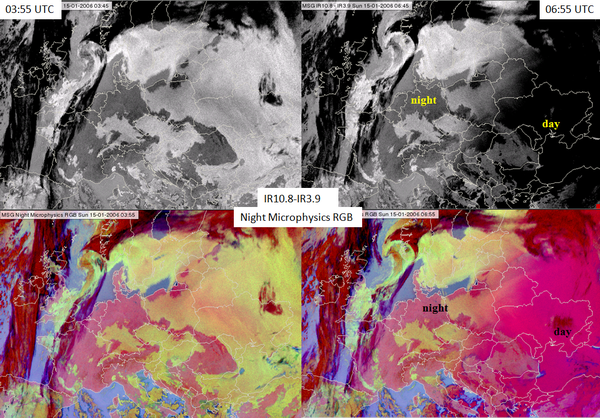
Fig. 11 shows the (IR10.8-IR3.9) difference image (up) and the Night Microphysics RGB image (bottom) at night (left panels) and at 06:55 UTC (right panels) when the sun is already up in the east, while in the western areas it is still night. There is a pronounced difference between the day and night parts of the images.
|
Figure 11: The (IR10.8 - IR3.9) difference image (top) and the Night Microphysics RGB image (bottom) for 15 January 2006 at 03:55 UTC (left) and 06:55 UTC (right)
|
|
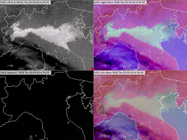
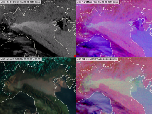
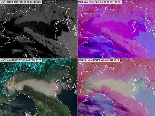
At dawn and dusk (twilight) the fog or water clouds 'disappear' from the Night Microphysics RGB. This happens because the (IR10.8-IR3.9) difference is positive at night and negative in the day, while at a low solar elevation angle it is around zero, like for a cloud-free surface (see Figs. 12 a, b and c).
|
Figure 12a: (IR10.8 - IR3.9) difference image (upper left), Night Microphysics RGB (upper right), Natural Colours RGB (bottom left) and 24 hour Microphysics RGB (bottom right) images for 20 March 2014 at 04:55 UTC
|
|
|
Figure 12b: (IR10.8-IR3.9) difference image (upper left), Night Microphysics RGB (upper right), Natural Colours RGB (bottom left) and 24 hour Microphysics RGB (bottom right) images for 20 March 2014 at 05:55 UTC
|
|
|
Figure 12c: (IR10.8-IR3.9) difference image (upper left), Night Microphysics RGB (upper right), Natural Colours RGB (bottom left) and 24 hour Microphysics RGB (bottom right) images for 20 March 2014 at 06:25 UTC
|
|
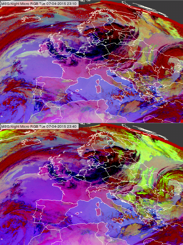
Around solar equinox the IR3.9 channel may contain some solar radiation (stray light) around midnight, spoiling the Night Microphysics RGB in some areas. The bottom panel of Fig. 13 shows such a situation. The upper panel shows the area half an hour earlier, without stray light. The stray light effect appears only on few images (see Animation 3).
|
Figure 13: Night Microphysics RGB images for 7 April 2015 at 23:10 and 23:40 UTC. The bottom panel shows the stray light effect.
|

|
|
Animation 3: 30-minute Night Microphysics RGB images (27 August 2006 at 22:00 UTC - 28 August 2006 at 02:00 UTC) some with stray light. (Source: Jochen Kerkmann, MSG Interpretation Guide, EUMETSAT)
|
|
|
Due to the limitations of Night Microphysics, such as the problem caused by the presence of the solar radiation, the 24 hour Microphysics RGB is officially recommended for operational fog/low stratus detection. It is usable the whole day, and works well also over Scandinavia. However, the parallel use of Night Microphysics RGB images might be beneficial because of the better colour contrast.