This chapter contains the radiosounding measurements in 1000, 925, 850, 700 and 500 hPa. This shows us the vertical wind shear, especially the wind's turn with increasing height yielding different temperature advections. When we observe right turning in the lowest levels and almost no or even left turning above we get hints to increasing potential instability.
measurements in 1000 hPa are only available in flat areas. The radiosoundings reveal over France and South Germany right turning between 1000 and 850 hPa. Whereas over France we observe the right turn also in higher levels the measurements reveal over Germany partly left turning. This indicates in creasing potential instability over South England and Germany. Over France we have warm air advection in low and middle levels.
The radiosoundings reveal over France and South Germany right turning between 1000 and 850 hPa. Whereas over France we observe the right turn also in higher levels the measurements reveal over Germany partly left turning. This indicates in creasing potential instability over South England and Germany. Over France we have warm air advection in low and middle levels.
The radiosoundings reveal over France and South Germany right turning between 1000 and 850 hPa. Whereas over France we observe the right turn also in higher levels the measurements reveal over Germany partly left turning. This indicates in creasing potential instability over South England and Germany. Over France we have warm air advection in low and middle levels.
The radiosoundings reveal over France and South Germany right turning between 1000 and 850 hPa. Whereas over France we observe the right turn also in higher levels the measurements reveal over Germany partly left turning. This indicates in creasing potential instability over South England and Germany. Over France we have warm air advection in low and middle levels.
The radiosoundings reveal over France and South Germany right turning between 1000 and 850 hPa. Whereas over France we observe the right turn also in higher levels the measurements reveal over Germany partly left turning. This indicates in creasing potential instability over South England and Germany. Over France we have warm air advection in low and middle levels.
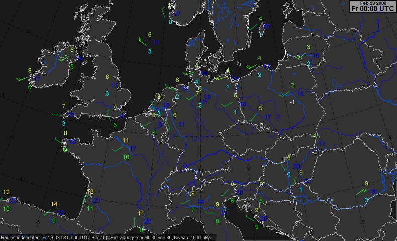
The radiosoundings reveal over France and South Germany and the Chech Republic right turning between 1000 and 850 hPa. Over France and England we observe the right turn also in higher levels. This indicates increasing potential instability over South Germany. Over France and England we have warm air advection in low and middle levels.
The radiosoundings reveal over France and South Germany and the Chech Republic right turning between 1000 and 850 hPa. Over France and England we observe the right turn also in higher levels. This indicates increasing potential instability over South Germany. Over France and England we have warm air advection in low and middle levels.
The radiosoundings reveal over France and South Germany and the Chech Republic right turning between 1000 and 850 hPa. Over France and England we observe the right turn also in higher levels. This indicates increasing potential instability over South Germany. Over France and England we have warm air advection in low and middle levels.
The radiosoundings reveal over France and South Germany and the Chech Republic right turning between 1000 and 850 hPa. Over France and England we observe the right turn also in higher levels. This indicates increasing potential instability over South Germany. Over France and England we have warm air advection in low and middle levels.
The radiosoundings reveal over France and South Germany and the Chech Republic right turning between 1000 and 850 hPa. Over France and England we observe the right turn also in higher levels. This indicates increasing potential instability over South Germany. Over France and England we have warm air advection in low and middle levels.
In many parts of this images' sequence we observe right turning of wind indicating warm air advection and a strong increase of wind speed with increasing height in the lowest about 2 km. This is a clear hint to convection's development because we observe this strong wind shear near the cold front. Such high vertical windshears are also an indication for possible tornados, especially during the colder seasons. The high wind speeds in 850 and 700 hPa are also a hint to severe gusts (50 to 70 knots even in flat countries) because the air is potential unstable which fits rather well with corresponding wind measurements in 10 m.
In many parts of this images' sequence we oberve right turning of wind indicating warm air advection and a strong increase of wind speed with increasing height in the lowest about 2 km. This is a clear hint to convection's development because we observe this strong wind shear near the cold front. Such high vertical windshears are also an indication for possibly tornados, especially during the colder seasons. The high wind speeds in 850 and 700 hPa are also a hint to severe gusts (50 to 70 knots even in flat countries) because the air is potential unstable which fits rather well with corresponding wind measurements in 10 m.
In many parts of this images' sequence we oberve right turning of wind indicating warm air advection and a strong increase of wind speed with increasing height in the lowest about 2 km. This is a clear hint to convection's development because we observe this strong wind shear near the cold front. Such high vertical windshears are also an indication for possibly tornados, especially during the colder seasons. The high wind speeds in 850 and 700 hPa are also a hint to severe gusts (50 to 70 knots even in flat countries) because the air is potential unstable which fits rather well with corresponding wind measurements in 10 m.
In many parts of this images' sequence we oberve right turning of wind indicating warm air advection and a strong increase of wind speed with increasing height in the lowest about 2 km. This is a clear hint to convection's development because we observe this strong wind shear near the cold front. Such high vertical windshears are also an indication for possibly tornados, especially during the colder seasons. The high wind speeds in 850 and 700 hPa are also a hint to severe gusts (50 to 70 knots even in flat countries) because the air is potential unstable which fits rather well with corresponding wind measurements in 10 m.
In many parts of this images' sequence we oberve right turning of wind indicating warm air advection and a strong increase of wind speed with increasing height in the lowest about 2 km. This is a clear hint to convection's development because we observe this strong wind shear near the cold front. Such high vertical windshears are also an indication for possibly tornados, especially during the colder seasons. The high wind speeds in 850 and 700 hPa are also a hint to severe gusts (50 to 70 knots even in flat countries) because the air is potential unstable which fits rather well with corresponding wind measurements in 10 m.
Over Chech Republic, Austria, Slovakian Republic, Hungary, Slovenia, Croatia we observe a right turn of wind in low levels and in upper levels no or even left turning yielding increasing potential instability in the forefield. Over parts of Germany weak right turning in the lower levels (till 700 hPa) can be observed.
Between the low mountains of Germany and the Alps the strong vertical wind shear between 0 and 2 to 3 km still existed.