Radar RX (national composite) Time Sequence 15-30 Min: 29 February to 01 March 2008
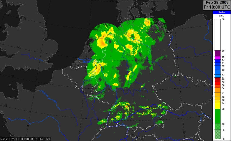
29 February 2008, 18.00 UTC - DWD-national-composite: reflectivities
Radar reflectivites (DWD-national-composite)
The reflectivites (legend: click upon the key-symbol, above) in the images of 18 to 23 UTC are related to partly heavy rain over North France, Benelux-Countries and the western parts of Germany. (The blueish pixels over Northwest Germany, e.g., at 21:15 are probably due to sleet because the radar measurments were taken in 1 km height.). When we consider the IR-enhanced from 21 UTC we see that intense rain over Northwest Germany can be observed at a split front.
The sequence between 23:00 and 01:45 shows convective line during its movement from the Dutch coast to North Germany. Reflectivities up to 50 dBz (probably graupel/hail, sleet?) were detected.
The images from 2:00 to 8:30 are zoomed. However, due to the fast convective line's movement the considered domain had to be shifted from time to time.The images reveal the formation and the continous extension of the convective line. A small and very long band that extended temporarely from the west edge to the east edge of the DWD-national composite moved fast to the Southeast without major changes. High reflectivites (up to about 50 dBz) were measured. We find several bow structures indicating areas of possibly severe gusts. The round-shaped and blueish area around Dresden from 7:15 to 7:45 was probably due to the so-called Bright-band-effect (high reflectivities due to sleet and attenuation of structures that were farer away from Dresden).
Especially from these images it becomes obvious that radar images reveal more information about precipitation intensity and type than satellite images.
After 8:30 UTC the convective line weakened. We still have to use zoomed images. This happened first at the west parts later on also at the east part.
")