
The Airmass RGB images below show the different air masses in relation to the cyclone. During 29th February we recognise stratospheric air that overun the frontal cloud band (pinkish clouds, southeast of low's centre, yielding split front). The cold front and convective line were in the left exit of the jet streak. From the violet to purple colouring we see that both systems were superimposed by high potential vorticity which indicates its intensification.
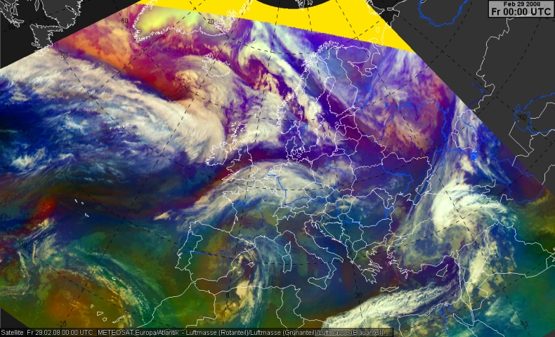
29 February 2008, 00.00 UTC - Meteosat Airmass RGB
|
Satellite Overview
Meteosat IR10.8 Enhanced and significant weather, time sequence [3h]
The first chapter dealing with the synoptic situation describes the development seen with infrared imagery. A time sequence of the IR10.8 channel is presented with enhanced colours. This enhancement enables us to study the different cloud top temperatures more in detail yielding most relevant parts.
RGB Composites
Airmass RGB: Meteosat-8; 6.2-7.3, 9.7-10.8, 6.2i: time sequence [3h]
In this chapter the convective processes are studied using the Airmass RGB. This composite gives information about different airmasses in relation to cloud structures. Additionaly, it contains hints to relevant dynamical processes (e.g., PV maxima). An 3h time sequence is pictured.
Severe Storms RGB: Meteosat-8; 6.2-7.3, 3.9-10.8, 1.6-0.6: time sequence [30min]
This RGB is available only during daylight. In this chapter the convective development in relation to the convective is studied. The rapid development stages will be observed in a 30 minutes time sequence.
RGB HRV, HRV, IR 10.8: time sequence [30min]
This composite is available only during daylight, too. In this chapter we will consider more in detail the cloud structures which will be better detected by the HRV channel and we will concentrate only upon the most relevant time (1st March 2008).
Basic Synoptic Parameters
Surface observations, wind barbs, T2m: time sequence [3h]
Surface observations in combination with the wind barbs and temperatures in 2 m are given for indentifying the significangt weather, different airmasses and surface fronts.
Geopotential height 300 hPa, Airmass RGB: time sequence [3h]
In the following chapter the cloud configurations in airmass composites are related to the basic fields of the geopotential in 300 hPa.
Wind in 300 hPa, Airmass RGB: time sequence [3h]
In the following chapter the cloud configurations in airmass composites are related to the basic fields of the upper level wind in 300 hPa near the level of the polar jet.
Surface pressure, Airmass RGB: time sequence [3h]
In the following chapter the cloud configurations in airmass composites are related to the basic fields of surface pressure (reduced to NN) in oder to see for example the relative position of the surface low to the areas of relatively high potential vorticity.
Surface pressure and T850 hPa: time sequence [3h]
In the following chapter model fields of surface pressure (reduced to NN) and the temperature in 850 hPa are considered. This combination gives hints to the position of the cold front, thermal advection and of areas with high surface pressure gradients.
Surface pressure tendencies, gusts, IR10.8: time sequence [3h]
In this chapter the pressure tendencies and gusts in relation to the IR 10.8 image are shown in order to investigate mesoscale structures more carefully.
Additional remote sensing data
Lightning and airmass composite: time sequence [1h]
In this chapter we discuss the combination of the airmass composite and the lightning detections during the last hour. We will consider in to what extend different airmasses and dynamical forcings caused the partly severe thunderstorms.
DWD RX (national composite): animation [15-30min]
This chapter offers the radar reflectances over Germany. The RX product (national radar composite, 1x1 km resolution in 1km height) by the Deutscher Wetterdienst (DWD) is used. We will only consider the passage of the convective line over Germany. Because 64 images will be used only an anmination with one text with the most relevant features will be presented.
1h-precipitation (radar and measurements): time sequence [1h]
This chapter contains the precipitation amounts during 1 hour (surface ,measurements and derived from radar in order to fill the gaps). As in the chapter before, we will only consider the passage of the cold front and of the convective line over Germany.
Doppler radar of Frankfurt: Radial winds, time sequence [15 Min]
You should consider this chapter if you have already experience in interpretating Doppler images. Otherwise you may skip this chapter. We will discuss the radial winds of the Doppler radar near Frankfurt. However, we will only concentrate upon the convective line's passage and therefore only a time period of 3 hours. The Doppler images are available every 15 minutes and covers a distance of 120 km from the radar station with a horizontal resolution of 1 km. These images represent the radial wind speeds in 2 km height.
Conditions over the Netherlands and Austria
Material from the Netherlands (Rob Groenland, KNMI)
In this chapter the conditions over the Neherlands will be investigated. We will only concentrate upon the 1 March from 00 to 03 UTC. Corresponding airmass-RGBs, the radiosoundings and hodogramme from De Bilt, NWP and radar images will be discussed.