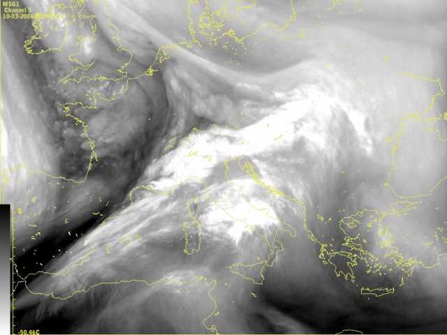
10 March 2006, 00 UTC
The most characteristic features in this image are the sharp rear
cloud edges and the black stripe of dry air parallel to the cloud band (pronounced contrast from white to black).
10 March 2006, 02 UTC
The situation is similar to the one two hours before. From the image it is
clearly recognizable where the front is situated. The brightest areas are
the ones with the most humid air in the upper troposphere. At the rear, especially southern part of the frontal cloud band, a dark stripe can be seen,
indicating the
intrusion of dry startospheric air into the lower parts of the atmosphere.
10 March 2006, 04 UTC
The sharp edge from white to black at the back side of the cold front is
revealing the position of the jet stream.
Over the northern Italy a developed wave can already be seen, having a form of
the cloud bulge. Another interesting thing in this image is the cloudiness
between Balearic islands and Corsica. It is a new wave that will build up in few hours.
10 March 2006, 06 UTC
The situation is very similar to the one two hours before. The only difference is that the cloud bulge already exhibits some spiral structure and the new wave is further
developing.
10 March 2006, 08 UTC
Development goes on. The form of the cloudiness and the wave over the north Italy is strongly influenced by
the strong upper level winds.
At this point in time one could see the double structure of the wave. Slightly brighter cloudiness
is located over Corsica then in the southern region of
the wave. For comparison see further examples in the Satmanu in the chapter "Conceptual Models-Wave-Special
Investigations-Waves with double structure".
10 March 2006, 10 UTC
The double structure of a wave is still recognizable but as the dry air overruns this part of
the wave it causes the cloud dissipation.
10 March 2006, 12 UTC
At this point in time the wave is strongly developed and it is placed over the north Adriatic. The cloudiness is more pronounced and very bright. Also, the dark stripe
intensified in the last few hours and now there is a very sharp boundary between frontal cloud band and dry stratospheric air.
10 March 2006, 14 UTC
The system moved more easterly and the dark stripe behind the cold front is very
pronounced.
10 March 2006, 16 UTC
At this moment the dark area is cleary visible at the southern rear part of
the cold front whereas the sharp boundary in the northern part is not present
any more.
10 March 2006, 18 UTC
The frontal cloud band of our interest moves further to the east and the influence of
the jet stream is further weakening.
.
10 March 2006, 20 UTC
Two features are strongly noticable in this image; the second wave on the cold
front that is further developing into the cloud spiral and the new system that
is approaching from the north-west.
10 March 2006, 22 UTC
The wave developed into a cloud spiral and strongly influences the weather in eastern part of Europe. The extensive surface low can be seen in chapter
'IR images and Geopotential height at 1000 hPa'.
10 March 2006, 23 UTC
The image and its content is very similar to the one 1 hour earlier. The only
difference is that the cloud system shows a small dissipation and the whole
feature is weakening.