Satellite Overview and Synoptic Situation
13 February 2005, 12 UTC
|
|
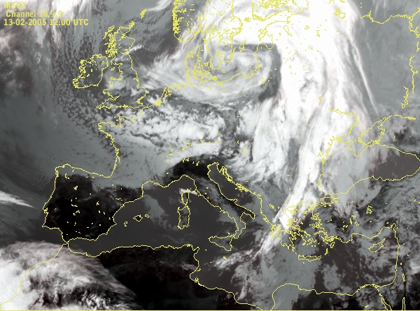
This case study presents cyclogenesis in the Genoa Bay, one of the most common cyclogenesis in the Mediterranean. The most significant feature that followed this development was a very strong mistral wind on south coast of France and on sea between the Baleares and Sardinia.
Satellite overview Development of the cyclone can be followed by the loop of IR imagery, whereas more detailed features are found in the HRVIS images but only during daytime. Air masses that took part in the development are analized by means of Aimass RGB images.
Meteosat 8 IR 10.8 µm : time sequence
Meteosat 8 high resolution visible images : time sequence
Meteosat 8 combined satellite imagery (Airmass RGB) : time sequence
Basic synoptic parameters
Meteosat 8 IR 10.8 µm and Geopotential Height 1000 hPa
Cloud configurations in satellite images combined with the basic field of surface pressure represented by geopotential height in 1000 hPa are shown here in 6-hourly sequence.Meteosat 8 IR 10.8 µm and Geopotential Height 500 hPa
The upper level situation is shown by 500 hPa height in 6-hourly sequence.Meteosat 8 IR 10.8 µm and Wind at 1000 hPa
The cyclogenesis and developement of the Mistral at the low level can nice be followed by the wind field at 1000 hPa in the 6-hourly sequence.Meteosat 8 IR 10.8 µm and Surface wind in Gulf of Lyon
In the folowing chapter the comparison of the surface wind field produced by the model and the wind observations are shown in 6-hourly sequence. The nice correspondance can be seen between the model field and the measurements.Meteosat 8 IR 10.8 µm and Wind at 300 hPa
The distribution of the wind speed in the upper level and the position of the jet plays an important role in the development of the cyclon. In this chapter isotachs at 300 hPa are displayed and described in a 6-hourly sequence.
Summary In this chapter the overwiev of the process of cyclogenesis in the Genoa Bay was given through satellite imagery and basic meteorological parameters. The origin of the Mistral and more detailed analysis of the wind field was given in the Vertical Cross Section chapter.
Satellite images showed that cyclogenesis in Genoa Bay started in the evening on 13th February. The similar, but smaller process soon started over Adriatic, and after some time, at the end of 15th February, also over land (Hungary). The center of cyclone moved from the West Mediterranean to the south and south east and development was triggered by intrusion of cold stratospheric air. The airmasses which was included in the process can nice be seen in the Airmass RGB satellite images.
We also noticed that the jet streak and surrounding sinking dry air played an important role in the cyclogenesis in the Mediterranean.
The surface and upper level low are quite intensive during the mature phase of the cyclogenesis. The upper level trough and later the upper level low is just in the beginning of the process behind the surface low. From the 00 UTC 15th February a thick, intensive low system from the surface up to high levels was present.