Authors
Meteorological and Hydrological Service of Croatia - DHMZ
Dunja Placko-Vrsnak
Natasa Strelec Mahovic
Dunja Drvar
Introduction
The Mediterranean Sea is a region that possesses a high frequency of cyclones - due to some authors, it is one of the most cyclogenetic regions in the world. Many of cyclones are lee depressions, mesoscale and weak, but others are strong and cover a wide area.
The path of the cyclones shown here (Figure 1) are the most common tracks in the Mediterranean during the winter season. The physical reason for the changes in the cyclonic routes from month to month
may be found in the changing land-sea contrast in association with the complex topography of the region.
In general the three winter months are similar in that the major route is in the northen section of the Mediterranean, but some feature are different. First, the
cyclones do not leave the Mediterranean by the same routes. From the Gulf of Genoa down to the Tyrrhenian Sea three different route can be noticed. The red one,
which may or may not start in the Gulf of Genoa (marked with 5) through the Aegean Sea to the Black Sea appears mostly in December. The cyan track (4) correspond to cyclones which moves
toward the Black Sea more to the north. That route is most common in the February. A third route (white, marked with 3), leaving the western Mediterranean across the Italy to the north-east
appears only in February. The north African cyclonic routes (orange, 2) varies through the winter. In December-January the cyclones originate in the west near the Atlas
Mountains, and move to the north-east directly toward the western Mediterranean, but in the February they tend to move along the north African coast with most easterly track.
The path of the cyclones in the west Mediterranean (green, 1) goes from south coast of Spain toward the Gulf of Genoa. In general in the cold season (winter) the low pressure
centers are placed over sea.
Fig 1. Schematic of the tracks of the cyclones in the Mediterranean during the winter season
Because of such cyclonic activity the Western Mediterranean is the region on which is payed attention in the past, especially during the ALPEX-SOP (The Special Observation Period of the Alpine Experiment). Investigetion of many cases of orographically induced cyclones in the western Mediterranean showed that at least two types of cyclogenesis can be distinguished : the so-called "Ueberstroemungs"-type and "Vorderseiten"-type. The first takes place below a north to northwesterly, the second below a southwesterly upperlevel flow.
In this case the development started in the Genoa Bay triggered by the strong north upperlevel flow. In the first phase of cyclogenesis the blocking and flow splitting of the cold air due to the Alps and the canalization between the Alps and Massif Central are important. That lead us to put this case of cyclogenesis under "Ueberstroemungs" type.Very soon the second minimum appeard in the Adriatic sea (Figure 2) and than the centers moved to the south-east and became deeper. High gradient in the pressure field accros the west Europe suggests very strong wind with gusts up to 85 knots - Mistral, which was spreading from France and Switzerland over the Western Mediterranean.
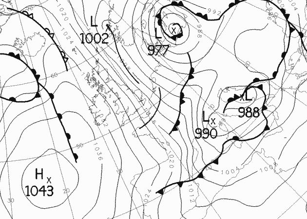
Fig 2. Surface chart analyse for 14 February 2005, 00 UTC
The Mistral is a kind of foehn wind, too. When a high-pressure system grips the plateau of the Massif Central, and a low-pressure area squast over the Mediterranean, the cold mountain air can begin to flow downhill, accelerating dramatically as it roars through the gap of the Rhone valley, before it turns and breaks eastward up the coast.
The sheer strength of the Mistral winds is well documented by the case of the cruise ship "Voyager", with 480 passengers and 296 crew, which got into serious difficulties in the Mediterranean, close to Menorca (Figure 3). A heavy sea with mountainous waves smashed windows on the bridge and knocked out the ship's power supply. The ship was taking on water and was adrift for about 4 hours. Luckily, the "Voyager" eventually managed to get 2 of its 4 engines started and arrived savely at Cagliari in Sardinia.
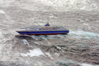
Fig 3. The damage of the cruise ship "Voyager" coused by Mistral
Strong wind persisted throughout the whole day on 14 February both on the coast as well on sea, which is well documented in synop measurements. The gusts were reaching 85 knots :
References
Alpert, P., Neeman, B.U., Shay-El, Y., 1990: Intermonthly Variability of Cyclone Tracks in the Mediterranean. Journal of Climate, Vol. 3, 1474-1478.
Campins, J., Genoves, A., Jansa, A., Guijarro, J.A., Ramis, C., 2000: A Catalogue and a Classification of Surface Cyclones for the Western Mediterranean. International Journal of Climatology, 20, 969-984.
Pichler, H., Steinacker, R., Lanzinger, A., 1990: Cyclogenesis Induced by the Alps. Meteorology and Atmospheric Physics, 43, 21-29.
Pichler, H., Steinacker, R., Hagenauer, E., Jager, A., 1995: ALPEX-Simulation. Meteorology and Atmospheric Physics, 56, 197-208.