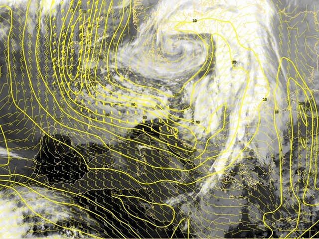
In this case, there was very dominant jet streak over the Atlantic reaching Ireland and West Britain from the north and curves across France.
The jet streak from the north spreading down to the Bay of Biscay. It curves over France and becomes the huge, very intensive west-east oriented jet. The cloud band over Italy and Adriatic are parallel to the jet.
The situation similar like a six hours before with maximum of wind over West Mediterranean. The clouds are located at the cyclonic side of the jet.
There is a relation between the cloud bulge area and the left exit region of a huge jet streak.
The jet streak and surrounding sinking dry air play important roles in the cyclogenesis in the Mediterranean. The emerging cloud head appears in the left exit region of a jet streak which is spreading from north to south down to Mediterranean.
The north-south oriented jet is connected with the west side of the deep upper level trouhg. The developing cyclone is oriented at the left-exit region of this branch and at the right entrance region of a south-west/north-east oriented jet-streak at the other side of the troughnean.
The situation in the wind field is similar like a six hours before. The cloud spiral over South Italy in the satellite image is less visible. The cloud band over Eastern Mediterranean moved further to the north-east.
The cloud intensification and the further development over South Italy and Adriatic happenes in the right entrance region of the jet oriented from south to the north-east.
The new intensification of the huge jet streak over Britain, France, South Mediterranea and North Africa goes on. The south branch of that circulation still plays a role in the development.
At this time step the cyclonic circulation over Genoa Bay can be noticed also at this level.
Similar situation like 6 hours before.
The new development over Hungary which can be followed in the IR imagery, also can be seen in the wind field at 300 hPa.
The position of the huge jet streaks, one from Baltic Sea over North France, down to Spain, and the other over North Africa over Mediterranean up to Balcan penninsula can be recognized also in the Airmass RGB imagery like a reddish stripe.
The system is dissipating but in the upper level it is still a strong cyclonic circulation almost all over West, Central and South Europe.