Mistral is a cold, northerly or northwesterly katabatic wind flowing into the Gulf of Lion from the southern coast of France. Although strongest in the Gulf of Lions, with sustained winds often exceeding 40 kt, and gusts sometimes to 100 kt, its effects are often felt past Sicily into the eastern portion of the Mediterranean basin. Wave heights associated with the mistral are commonly 4.5-6.0 m and have sometimes reached a maximum height about 9 m.
The mistral is most common in winter and in spring, with the strongest episodes tending to occur in the transition between those
two seasons. Duration of effects with winds exceeding 30 kt for over 65 hours
have been reported at some locations. Although gale-force events can occur
year-round.
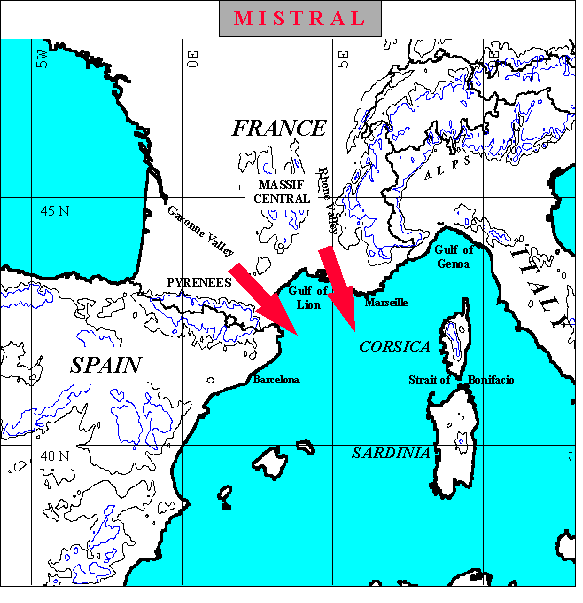
The wind is characterized by the sinking of cold air generated over the mountains and then funneled through the Garone Valley between the Pyrennes and the Massif Central and through the Rhone Valley farther east between the Massif Central and the Alps. In the winter, wind speeds can reach over 100 knots off the southern coast of France. Gale-force Mistrals often develop when cyclogenesis occurs over the Gulf of Genoa with the passage of the 500 mb trough through eastern France. The effects of gale-force Mistrals can extend into the western and central Mediterranean, creating high sea states throughout the entire region, especially blowing through the Strait of Bonifacio between the islands of Corsica and Sardinia. Mistrals are considered the most dangerous of all Mediterranean winds because of their high speeds and persistence.
A favored sequence for mistral development is passage of a cold front into the Gulf in advance of a short wave trough at upper levels. The upper- level trough produces southwesterly flow aloft and positive vorticity advection over the position of the cold front in the Gulf. This pattern leads to cyclogenesis in the Gulf of Genoa. As the upper level trough advances so that northerly winds aloft are in phase with the northerly surface flow over Southern France, strong mistral winds occur (Fett, et al, 1981).
Mistral winds have been well documented in literature, as in the previous reference, with satellite visible and infrared data, and conventional weather reports. With the advent of Special Sensor Microwave Imager (SSM/I) data in the late 1980's it was possible to directly measure wind speed effects and changes in total integrated water vapor associated with a mistral.
| Map of Mistral | Caption |
References
- Manual of Synoptic Satellite Meteorology
Fett, R. W. et al., 1981, Navy Tactical Applications Guide (NTAG), Vol. 3, North Atlantic and Mediterranean, Naval Research Laboratory, Monterey, CA, pp200.