Sometimes its effects are felt even past Sicily into the
eastern portion of the Mediterranean basin.
Wave heights associated with the
mistral are commonly 4.5-6.0 m and have sometimes reached a maximum
height about 9 m.
The mistral is most common in winter and in spring, with the strongest episodes tending to occur in the transition between those two seasons, although gale-force events can occur year-round. It often builds up in the night, after midnight, or early in the morning, especially in the summer. It very rarely appears on a summer afternoon. Once established, the Mistral generally peaks in the afternoon and weakens in the evening. Most Mistrals last one to three days, sometimes extending to a full week. Duration of effects with winds exceeding 30 kt for over 65 hours have been reported at some locations. Mistral is considered the most dangerous of all Mediterranean winds because of its high speed and persistence.
PROCESS OF DEVELOPMENT
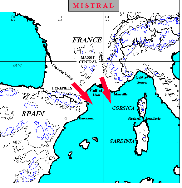
Mistral wind is characterized by the sinking of cold air generated over
the mountains and then funneled through the Garone Valley between the Pyrennes
and the Massif Central and through the Rhone Valley farther east between the
Massif Central and the Alps.
Gale-force Mistral often
develops when cyclogenesis occurs over the Gulf of Genoa with the passage of the
500 mb trough through eastern France.
A favored sequence for mistral development is passage of a cold front into the Gulf in advance of a short wave trough at upper levels. The upper- level trough produces southwesterly flow aloft and positive vorticity advection over the position of the cold front in the Gulf. This pattern leads to cyclogenesis in the Gulf of Genoa. As the upper level trough advances so that northerly winds aloft are in phase with the northerly surface flow over Southern France, strong mistral winds occur (Fett, et al, 1981). For the Mistral to blow, it is also necessary to have a pressure gradient along the coast, from higher pressure in the Pyrenees to lower pressure in the Appennines.
Mistral effects on the coast can be amplified if the air is much cooler than the sea.
References
-
Fett, R. W. et al., 1981, Navy Tactical Applications Guide (NTAG), Vol. 3, North Atlantic
and Mediterranean, Naval Research Laboratory, Monterey, CA, pp200.