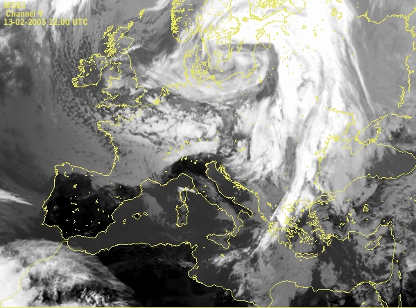
Cloud spiral over Baltic sea is connected with deep low. Cloud structure west of Great Britain indicates cold advection from north down to the South-west England and North-west France. In the Mediterranean some low clouds are present, and the Genoa Bay and North Italy are almost cloudfree zone.
Some cloud appear in the Genoa Bay as indication of development.
The intensification of the cloud band over Italy, Adriatic and Croatia goes on.
The indication of the cyclogenesis in the Genoa Bay and also the indication of similar process in the Adriatic can be seen.
The cloudiness over Croatia, Adriatic and Bosnia and Hercegovina indicate that some cyclonic developement will happen in Mid-Adriatc. From the other hand, the significant development in the Genova Bay will happen a few hours later.
The cyclogenesis was going on.
Notice the significant development in the Genoa Bay - cloud bulge west of Corsica. The similar structure can be seen over Croatia with small center over Mid-Adriatic.
The cloud bulge start to rotate and cyclonic development over Mediterranean can be seen. Over West Croatia the similar but smallest proces goes on.
In this time step also notice the thin cloud band coming from the South France down to the Gulf of Lyon. This cloudiness is directly
the consenquence of the mistral which was very strong during 14th of February. This very strong wind, over France down to the Mediterranean and the upper
level flow from the north, playing an important role in the cyclogenesis in the West Mediterranean.
The center of the cyclone (in the West Mediterranean) moves to the south and cyclogenesis goes on. The center over mid-Adriatic (Croatia) cant be seen properly but there is a cloud area which is connecting with warm front.
The cloud street over Mediterranean (Gulf of Lyon) can nicely be seen, too.
The center of the cyclone moves to the south-east. The Genoa Bay and the coast of France is mostly without the clouds and over Adriatic is warm front cloud band.
Cloud spiral north of Sicily is nicely developed. The cloudiness of the cold front (over South Italy and Mediterranean down to the coast of Africa) and the warm front cloud band (over Adriatic toward north-east) can be noticed. Cloud structure over West Mediterranean indicates on cold advection.
Situation is similar like 3 hours before.
The center of the cyclone moved further to the east. Notice the cloudfree zone along the south coast of France.
The development of the system continued.
Convective cloudiness on the west and south part of the cyclonic system (in the mid-Mediterranean and over South Italy) shows the cold air till the cloudiness over land is connected with the warmer air.
The difference in the temperature can be seen also in the temperature field at 500 hPa.
Convective cloudiness intesified over Sardinia. The center of the deep low now is over South Italy and South Adriatic.
Convective development in the mid-Mediteranean is still present. At this time step the new one, in the middle of the Adriatic, appear.
The situation similar like 3 hours before, but in the cyclonic circulation is an indication of new development over Hungary.
Further intesification - convectiv development over sea and cyclonic development over land.
The development of the systems continued.
Convective development in the West Mediterranean indicate still strong cold advection. Cloud head over Slovenia, Austria and Hungary indicates the further development of the low.
The cyclona over Mediterranean became stationary, in the both, low and upper level. The development of the low over Hungary can be seen just in the field of geopotential at 1000 hPa, till the upper level low is misleading.
The cloudiness over Austria and Hungary was spreading to the North-east was connected with the warmer air. That can be also seen from the temperature field in the upper level. The major cyclone slowly weaking, but was still present accompanied with convective development.
Similar situation like 3 hours before.
Cloudiness over land became lower, with warmer tops.
The decay of the system continued.
The surface low became weaker but there was still some convection over South Italy.
The weak cyclonic circulation was still present over mid-Mediterranean. The high pressure over Atlatic becames stronger and was spread over Central Europe and West Mediterranean.