
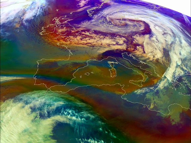
The first image of the time sequence shows the reddish area north of, and over Ireland and the Great Britain. It indicates dry, descending stratospheric air related with a jet stream.
More to the west, the bluish colour is releted with cold airmass with low tropopause, and greenish colour over South Italy and South Adriatic is releted with warmer air. The cold air is also present over Scandinavia, but it is connected with cyclonic flow over the Baltic Sea. The white and whitish colour indicates high and mid-levels clouds.
Note. You can always click on the to bring up the RGB-key.
The cold air continues to flow from north toward the east accros the West England and North France. The cold air (cold front) can be recognised as the low level cloudiness pictured in blue south of the Alps.
The intrusion of cold and dry air from north is also the region where the maximum wind speed were observed. The jet is evident also over Slovenia and Croatia with cloud band on the left side of the jet.
Dry descending stratospheric air, which appears in reddish colours, moves further to the south. The cloudiness in the Genoa Bay is an indication of cyclogenesis.
From now, in the one hour time sequence, developement of cyclone can be follow.
The strong upper level flow comes from north to south. Dry descending stratospheric air related to an advection jet appears in reddish colours goes over North Sea down to the France and Mediterranean. This is a process which triggers or enhances cyclogenesis - in this case cyclogenesis in Genoa Bay. The similar structure start to form over North Adriatic.
The mid-level clouds (light ocher) over West Mediterranean and Adriatic is an indication of cyclogenesis.
The mid-level clouds (light ocher) over West Mediterranean and Adriatic is an indication of cyclogenesis.
The reddish colour south of France, in the Gulf of Lion indicates the upper level PV anomaly that caused the cyclogenesis over the Gulf of Genoa. From the mid-level clouds (white, light ocher colours) we can assume a cyclonic formation in the next times steps.
The development of the systems countinued.
The development of the systems countinued.
We can now see significant development in the Genoa Bay. The similar structure can be seen over Croatia with small center over Mid-Adriatic. The upper level trough extended and sharpened.
The cloud bulge over West Mediterranean rotates and moves to the south-east. The second one, smallest, over Croatia also moves toward the east.
The cloud bulge over West Mediterranean rotates and moves to the south-east. The second one, smallest, over Croatia also moves toward the east.
The development goes on. The cloud spiral can nicely be seen west of Italy, over Corse and Sardinia. At the reare side of the frontal cloud band the dry descending air (reddish colours) still flowed from the north over France, west of the Alps, down to the West Mediterranean.
The development goes on. The cloud spiral can nicely be seen west of Italy, over Corse and Sardinia. At the rear side of the frontal cloud band the dry descending air (reddish colours) still flowed from the north over France, west of the Alps, down to the West Mediterranean.
The development in the Mediterranean goes on, and the smallest over Croatia dissipating. The cloud spiral can nicely be seen west of Italy, over Corse and Sardinia. At the rear side of the frontal cloud band the dry descending air (reddish colours) still flowed from the north over France, west of the Alps, down to the West Mediterranean.
The reddish colours over Great Britain and west part of Scandinavia and the North Sea which shows dry descending stratospheric air is related with two wind maxima at 300 hPa.
The development of cyclone continued trigerred by intrusion of stratospheric air down to the Mediterrain.
The same structure can also be seen in the water vapor imagery
(WV6.2)
where the dark stripes indicates the intrusion of the cold and dry stratosferic air.
The center of the cyclone moves to the south. Cold air mass spreading over Central Europe and the reddish stripe of the dry, stratospheric air is still present from North Italy over Croatia and Hungary.
The center of the cyclone moves to the south. Cold air mass spreading over Central Europe and the reddish stripe of the dry, stratospheric air is still present from North Italy over Croatia and Hungary.
The center of the cyclone moves to the south. Cold air mass spreading over Central Europe and the reddish stripe of the dry, stratospheric air is still present from North Italy over Croatia and Hungary.
The system moves toward the east and the cold airmass protrudening down to the Genoa Bay.
The system moves toward the east and the cold airmass protrudening down to the Genoa Bay.
As the cloudspiral develops and moves farther to the south-east, a strong signal in PV , which is connected with reddish colour, can be observed.
The system moves further to the east.
The system moves further to the east.
The system moves further to the east with some convective development in the cold air over West Mediterranean.
The system moves further to the east with some convective development in the cold air over West Mediterranean.
Similar situation like one hour before.
The well developed cyclone with centre over South Italy with two interesting features in this case - the intrusion of dry stratospheric air (reddish colour) at the rear side of the frontal cloud band and the cold airmass over North Italy and Mediterranean (bluish colour).
Cyclonic activity over South Italy goes on.
In the cold and dry air which flow down to the Mediterranean cellular cloudines indicates the convective development.
In the cold and dry air (reddish colour over huge area) which flow down to the Mediterranean cellular cloudines indicates the convective development.
The big and deep cyclone is still present over Italy and Mid-Mediterranean, at the low and upper level. The convective development is still present west of Corse but also in the Mid-Adriatic.
The cold airmass is over Mediterranean. Notice the cloud structure along the west coast of Italy - it may be triggered by orographic lifting.
In the cold airmass more convective development over West and Mid-Mediterranean. The cloudiness over land (Central Europe) indicates a new development.
In the cold airmass more convective development over West and Mid-Mediterranean. The cloudiness over land (Central Europe) indicates new development.
The developement of new cyclone can be seen over Hungary.
Notice that all convective cells over Mediterranean develop on WV boundaries (appears here as purple colour).
The developement of new cyclone can be seen over Hungary.
Notice that all convective cells over Mediterranean develop on WV boundaries (appears here as purple colour).
The circulation of the cold and dry air goes on and the secondary weak cyclone was still present.
The similar situation like 3 hours before.
The big reddish stripe is conected with dry descending air which can be seen again in the WV imagery. Inside that, the cold air mass is still present. The secondary cyclone is dissipating.
Notice the cold airmass (bluish colours) over Mediterranean.
The reddish stripe almost all over Europe and Mediterranean is related with dark stripe in WV image and maxima of wind at 300 hPa - this is the position of jet and the descending of dry stratospheric air.
The system was dissipating.
The system was dissipating.