Chapter VI: Main features of daytime AVHRR RGBs
Table of Contents
- Chapter VI: Main features of daytime AVHRR RGBs
- Main features of daytime AVHRR RGBs
Main features of daytime AVHRR RGBs
Day Microphysics RGBs are the best at cloud analysis in both scientific and forecast applications. They provide the best and more complete cloud-related information. The color contrasts between different cloud types and surface objects are clear (see Figs. 1-3). They contain information related to both microphysics and temperature. The other two daytime RGBs contain either temperature or microphysics information, but not both.
Natural Colours RGB images are the best source of information on vegetation. Cloud RGB also provides vegetation information but it combines it with temperature information, not with 1.6 reflectivity. The color contrast of vegetated area against bare soil is much better and stable in the Natural Color RGB (and bare soil is closer to its natural color, see Figs. 4 and 5).
For the public Cloud RGBs (in the convective season) and Natural Colour RGBs are the best. They are simple to interpret, and their colors are close to the natural ones.
The 'traditional' Cloud RGB is useful for high clouds. Thick and thin high-level clouds (e.g. the storm core and the anvil) are easy to distinguish (see Fig. 1). However, it is less informative during the winter, as it shows almost no color contrast between snow-covered land and water clouds/fog (see Figs. 2, 3 and the Alps in Fig. 5).
Fig. 1 shows a comparison of the three daytime AVHRR RGB types in a convective situation. Water and ice clouds are separated in all three images, but the color contrast is strongest in the Day Microphysics RGB image. Note that the contrast between thick and thin high-level clouds is the highest in the Cloud RGB.
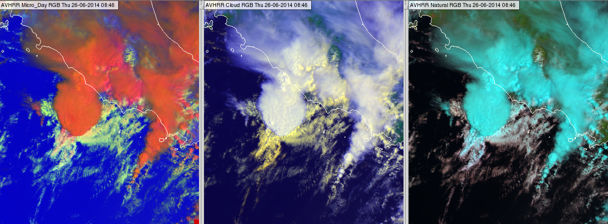
Figure 1: AVHRR Day Microphysics RGB (left), Cloud RGB (middle) and Natural Colour RGB (right) images off the coast of Italy on 26 June 2014 at 08:46 UTC
Figs. 2 and 3 show clouds over snow in northern Europe. Fig. 2 shows Greenland and Iceland. The water cloud (fog) over Iceland is much more visible in the Day Microphysics RGB than in the Natural Colour RGB. In the Cloud RGB it is hardly recognizable. The thin fog along the southern coast of Greenland shows best in the Day Microphysics RGB image. High level wave clouds consisting of small ice crystals are seen over Greenland (see the orange patterns in the Day Microphysics RGB). The thicker cirrus clouds are easily recognizable in the Day Microphysics and Cloud RGB images, while the thinner cirrus clouds show best in the Cloud and Day Microphysics RGB images.
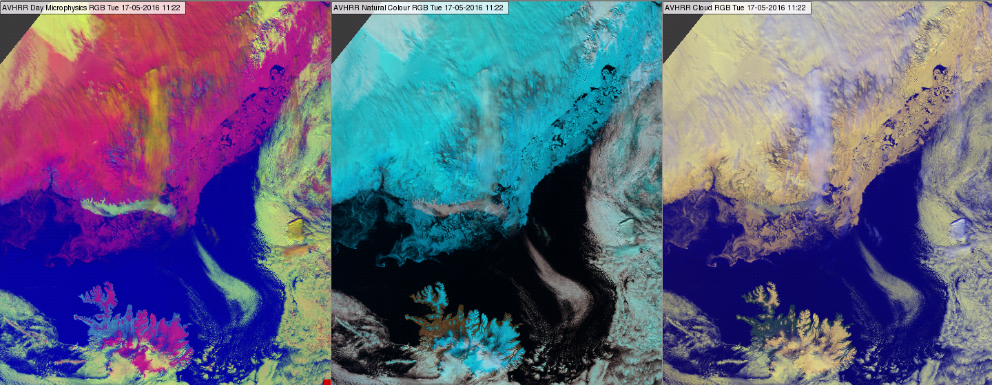
Figure 2: AVHRR Day Microphysics RGB (left), Natural Colour RGB (middle) and Cloud RGB (right) images of Greenland and Iceland on 17 May 2016 at 11:22 UTC
The encircled area in Fig. 3 is partly covered by (thin) water cloud. These water clouds are seen only in the Day Microphysics RGB image.
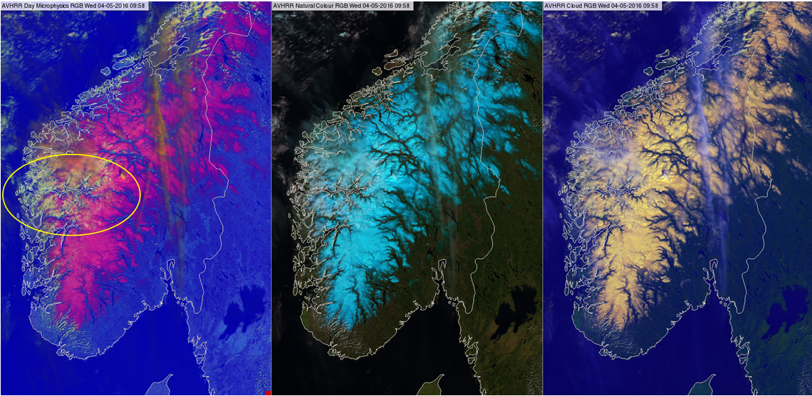
Figure 3: AVHRR Day Microphysics RGB (left), Natural Colour RGB (middle) and Cloud RGB (right) images on 4 May 2016 at 09:58 UTC
Figs. 4 and 5 show Cloud and Natural Color RGBs of a mostly cloud-free area. The contrast between vegetation and bare soil or desert is better in the Natural Color RGB, and the bare soil matches its natural color better.
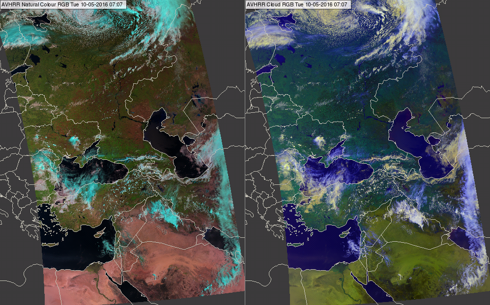
Figure 4: Figure 4: AVHRR Natural Colour (left) and Cloud (right) RGBs on 10 May 2016 at 07:07 UTC
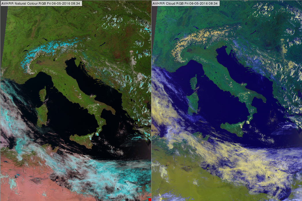
Figure 5: AVHRR Natural Colour (left) and Cloud (right) RGBs on 6 May 2016 at 08:34 UTC