Typical colors
The main purpose of this RGB type is to provide complex cloud analysis with good color contrast between cloud types and against the surface.
Fig. 7 shows the typical colors of METOP AVHRR Day Microphysics RGB images. These are only examples and do not display every color and tone available to the RGB type. Note that the brightness and shades of the colors may vary across the swath; for more about this see the chapter 'Effects of the scanning geometry'.
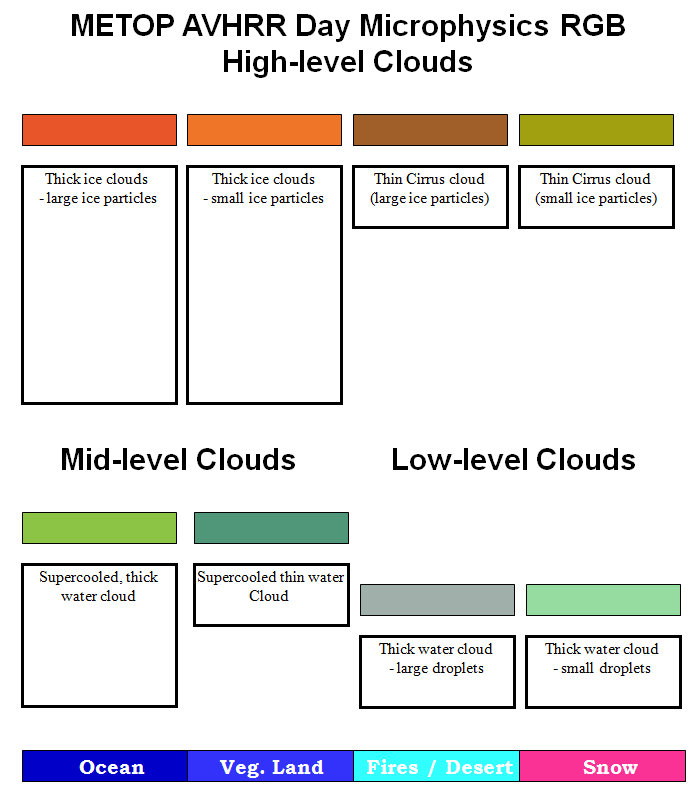
Figure 7: Typical colors of METOP AVHRR Day Microphysics RGB images
Typical colors of the clouds:
The Day Microphysics RGB type contains information on cloud thickness, cloud top phase, particle size and cloud top temperature.
- Thick ice clouds are magenta, red-orange or orange;
- relatively warm thick ice clouds appear magenta,
- cold, thick ice clouds with large particles are red-orange,
- cold, thick ice clouds with small ice crystals on their tops appear orange.
- Thin ice clouds are
- 'dirty' orange (brownish),
- dirty orange with green shades in the case of small ice crystals (see Fig. 9a),
- bright green in cases with extremely small ice crystals (see Fig. 9b).
- Thick mid-level supercooled water clouds are bright medium green.
- Thin mid-level supercooled water clouds appear medium green with a tint of the color of the underlying surface.
- Thick, low-level water clouds with large droplets are gray.
- Thick, low-level water clouds with small droplets are light green.
The color of a semi-transparent cloud depends on the color of that cloud type, its transparency and the color of the underlying surface.
Typical colors of cloud-free regions:
- open water surfaces (ocean, sea, big deep lakes) are medium blue, except for increased aerosol content (like dust clouds) or sunglint,
- snow-free land is bluish or purple - the tones may vary depending on temperature and surface type,
- desert appears light cyan,
- snow-covered land is magenta.
Open water surfaces are usually medium blue in AVHRR Day Microphysics RGB images. Areas with sunglint are an exception. Sunglint is the mirror-like reflection of sunlight off a water surface. Sunglint occurs at a given geometry between the sun and satellite viewing directions. In areas of sunglint an increased amount of solar energy is reflected from the water surface. Smooth ocean water becomes a 'silvery mirror', while rougher surface waters (with big waves) appear less bright. As seas are nearly never perfectly smooth or calm, the Sun's reflection gets blurred giving the water surface a washed-out appearance. Since the reflection is more intense in the NIR1.61 channel than in NIR0.87, and since there is no reflection in the IR10.8 channel, the sunglint appears greenish cyan in Day Microphysics RGB images. Fig. 8 shows examples of weaker and stronger sunglint cases. Note that in Metop AVHRR images (morning orbit), the sunglint area is typically on the eastern side of the satellite ground track.

Figure 8: Sunglint over the Mediterranean in AVHRR Day Microphysics RGB images on 6 May 2016 at 09:19 UTC (left) and 24 May 2016 at 08:58 UTC (right)
The following two examples show cirrus clouds with small particles. Fig. 9a shows a case where the front cloudiness is polluted by dust from the Sahara. The left panel shows an AVHRR Day Microphysics RGB image. The right panel is the best matching Meteosat SEVIRI Dust RGB image, included here to confirm that the front cloudiness really is polluted by Sahara dust. (The pink color in SEVIRI Dust RGBs indicates a dust cloud.) In the AVHRR Day Microphysics RGB image the cirrus shield is greener than usual due to the presence of small ice crystals.

Figure 9a: METOP-B AVHRR Day Microphysics RGB (left) and MSG SEVIRI Dust RGB (right) images of the Mediterranean Sea region on 8 April 2016 at 08:10 UTC
Fig. 9b shows high-level lee clouds south and southwest of the Alps. They appear bright green in the AVHRR Day Microphysics RGB image (upper panel) because they consist of extremely small ice crystals. A SEVIRI Day Microphysics RGB is shown in the bottom panel for comparison. (This link shows what such cirrus cloud with small ice crystals looks like from the ground.)
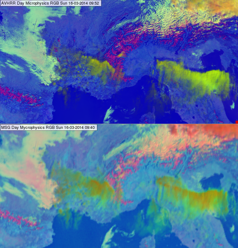
Figure 9b: AVHRR Day Microphysics RGB (top) and SEVIRI Day Microphysics RGB (bottom) images of the Alps region on 16 March 2014 at 09:52 and 09:40 UTC