Urban Heat Islands
The Urban Heat Islands effect has been a topic of increasing concern over the last decades. By replacing plants (which cool their surroundings by evaporating water) with impervious surfaces, heat is trapped, leading to city centers warmer than surrounding rural areas by several degrees. A variety of factors are involved in the phenomenon, but overall bigger cities tend to have stronger heat-trapping capacities than smaller ones and cities surrounded by forest have more pronounced heat islands than cities in arid environments. Figure 36 shows how big cities are easily identified in the LST map from 26 May 2012 at 13:00 UTC in the UK.
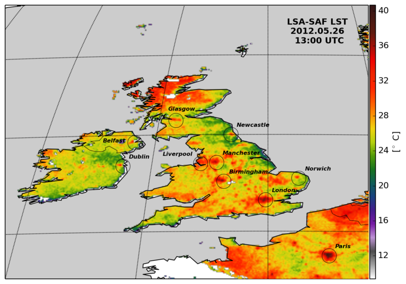
Fig. 37: Identification of large cities in the UK and Ireland using LST map product from LSA SAF on the 26 May 2012 at 13:00 UTC.
The UHI effect can be particularly dangerous during heat waves. This has actually been causing an increasing number of casualties among the elderly - particularly in southern Europe (http://www.urbanheatisland.info/). In light of this, ESA has funded a project (2008-2011) in which UHI trends over 10 European cities (Athens, Bari, Brussels, Budapest, Lisbon, London, Madrid, Paris, Seville, Thessaloniki) were analyzed over a period of ten years , using a multi-sensor approach in order to make the best use of all satellite missions that carry TIR sensors (SEVIRI, AVHRR, AATSR, MODIS, LANDSAT, ASTER). The purpose was to aid decision and policy makers in mitigating the effects of UHIs through appropriate alert systems and, in terms of reducing risk, through improved urban planning (http://www.urbanheatisland.info/).