Potential temperature - meteorological explanation
Potential temperature can be used to compare the temperature of air parcels that are at different levels in the troposphere. Since temperature tends to decrease with height, it is difficult to note which regions in the troposphere are experiencing warm and which cold advection. Bringing air parcels adiabatically to a standard level (1000 hPa) allows comparisons to be made between air parcels at different elevations. If the potential temperature of an air parcel at one pressure level is lower than that of air parcels at other pressure levels, a forecaster can conclude that cold air advection exists at the pressure level with the lowest potential temperature.
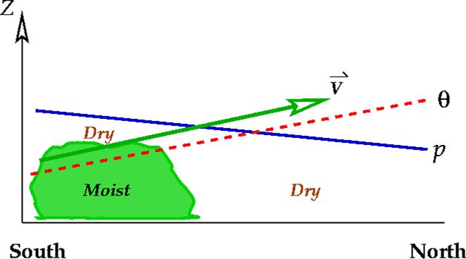
Moist air from low levels on the left (south) is transported upward and to the right (north) along the isentropic surface (adapted from Bluestein, 1992).
Air parcels tend to travel along constant potential temperature surfaces. This makes sense because constant θ surfaces represent "constant density" surfaces. The path of least resistance on an air parcel that is advecting is for it to remain at the same density as its environment. If a parcel is subjected only to adiabatic transformation as it moves through the atmosphere its θ remains constant. The term that describes this process is isentropic lifting / descent. Isentropic lifting / descent occurs whenever warm advection, cold advection or flow of one air mass over another occurs. Less dense air will tend to glide up and over more dense air (thus low level warm advection leads to rising air) when less dense air advects toward more dense air. The trajectories that wind vectors take over θ surfaces determine how much lifting or sinking will take place due to advection. Key points to remember are that
(1) air parcels in a convectively stable environment tend to advect along constant θ surfaces and
(2) low level warm advection produces isentropic lifting and uplift while cold advection produces isentropic downglide and sinking.
While potential temperature can be used to compare temperatures at different elevations and the trajectory air parcels will take (rising or sinking), equivalent potential temperature(θe) can be used to compare both moisture content and temperature of the air. The equivalent potential temperature is found by lowering an air parcel to the 1000 hPa level AND releasing the latent heat in the parcel. The lifting of a parcel from its original pressure level to the upper levels of the troposphere will release the latent heat of condensation and freezing in that parcel. The more moisture the parcel contains the more latent heat that can be released. θe is used operationally to map out which regions have the most unstable and thus positively buoyant air. The θe of an air parcel increases with increasing temperature and increasing moisture content. Therefore, in a region with adequate instability, areas of relatively high equivalent potential temperature (called θe ridges) are often the burst points for thermodynamically induced thunderstorms and MCS's. θe ridges can often be found in those areas experiencing the greatest warm air advection and moisture advection.