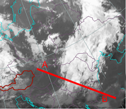
Vertical Cross Section Wave B: 3rd July 2004:06UTC
Isentropes
There is a very steeply downward inclined zone of higher gradients of isentropes leading into a bulge in the lowest layers. Therefore this is a very unstable frontal zone. Also the thickness ridge in front shows this instability.
The pixel values if IR show very distinct high values and the WV values are cleary lower. It is the area where the dry, probably stratospheric air is superimposed on the cloud band.
The VCS was laid from position A to B.
Temperature Advection
At this point of time, there is only cold advection in and in front of the area of the front. A very small maximum of WA at very high levels cannot be explained satisfactorily in the framework of the frontal system
Convergence
There is a large field of convergence in front of the frontal surface but also a maximum of convergence within the frontal surface.
Vertical Motion (Omega)
There is a maximum of downward motion in the lowest layer immediately in front of the frontal surface and distinct upward motion in the middle part of the troposphere. Bith features are not easily explainable as one would expect upward motion in lower layers in front of the frontal surface and fitting into the picture of low cloud tops downward motion above. In any case the strong upward motion in middle layers do not lead to condensation as the air is very dry.
Vorticity
There are some smaller values of vorticity within the frontal surface but the main cyclonic maximum can be found in high levels behind the frontal cloud band and could be connected to the jet streak.
Vorticity Advection
An intensive PVA maximum is in font of the vorticity maximum superimposed on the rearward side of the frontal cloudband.
PV
The PV = 1 isoline is relatively low down at about 500 hPa. But at the time being there is not yet a mesoscale PV anomaly recognisable.