- Development of a Front (known as frontogenesis).
- A Wave develops on the front.
- A cyclonic circulation (area of low pressure) becomes established.
- The cold front overtakes the warm front, initial stage of an occlusion.
- The development of the occluded front continues and the cyclone reaches its mature stage.
- The lifetime of a cyclone is about 3 to 5 days from the initial wave to the dissipating stage.
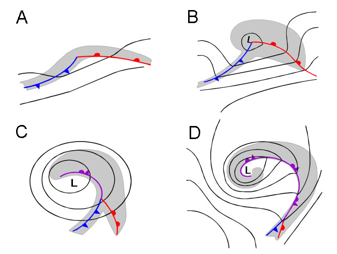
Fig 1. The lifecycle of a cyclone
In the above Figure 1 this lifecycle is graphically represented with the development of the Wave (A). Second the cyclonic circulation and the establishment of a low pressure area (B). In the third image (C) the cold front overtakes the warm front and an occlusion-front is formed. Lastly, the development of the occlusion continues and the cyclone has reached its mature stage (D).
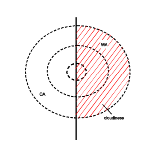
On the front of two airmasses (one Polar and one of Tropical origin; Fig 2.) a large horizontal temperature gradient exists. Due to this strong baroclinicty a transverse circulation is triggered causing disturbances. The transverse circulation is released by frontogenesis in the horizontal wind field and causes, besides a decrease in surface pressure, also an increase in upward motion and an increase of vorticity. The consequence of this disturbance is that cold air moves south-eastward and warm air moves north-westward and a Wave forms. This process continues and more warm air will protrude in the area which was formerly occupied by colder air (Fig 3.). The change in direction of the flow causes the surface pressure to decrease, with the lowest pressure found at the apex of the wave. In the following timesteps the cold front will advance faster and catches up on the the warm front and lifting the warm front. This last process is called occlusion and creates an occluded front.
Looking only at the kinematic processes a very simple description of the development of the S-shape cloudiness as well as of the typical distribution of the temperature advection field can be given. The cyclonic vorticity deforms the cloud band edge and transports cold and warm air, leading to typical positions of WA and CA maxima (see Key parameters ). The WA maximum within the cloud bulge as well as PVA, indicating the deepening of the low, contributes to the increase of cloudiness in the Wave area.
 |
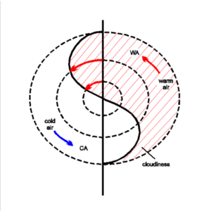 |
Fig 2. The initial stage where the front seperates the cold polar airmass and the warm tropical airmass. | Fig 3. Warm air invading the formerly polar area. The onset of a cyclone. |
References