- An atmosphere which is conditionally unstable.
- An external trigger mechanism that can start the convection.
A situation in which a "loaded gun" develops the absence of an external triggers causes the atmopshere to become very unstable. During such a situation the model often shows a region where all the ingredients for potential convective development are well present, making it tricky for a forecaster. The area is usually characterised by a Showalterindex of –3, Theta-E values are high and even convergence is found near the surface. Still the IR image reveals no (indication of) convective cells. The most likely cause that hampers the development of these cells are is because of a strong "cap".
Through the processes of diurnal heating the boundary layer becomes warm and moist. Under the assumption that a large difference in temperature between the boundary layer and the cold and dry upper troposphere exist, the boundary layer will become buoyant and its warm, moist air will attempts to rise. It is this convection that makes the atmosphere unstable. It does however happen that this upward motion is stopped by a capped inversion (short cap). This layer of inversion, where warm air is found over cold air, often exists because a layer of warm/dry air has become entrained in the airflow of some source. The capped inversion can not really be recognised from satellite image. An indication may be the non-existance of clouds in the unstable area. Without a cap the sensible and latent heat would continously be released as small clouds, preventing sufficient energy to build up and drive strong convection. The capped inversion can however easily be identified when studying radiosonde data.
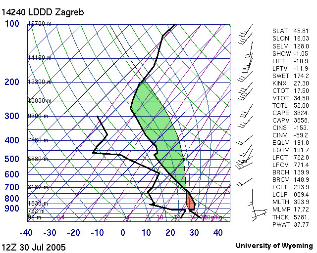
Figure 1 – Radio Sounding Plotted sounding from Zagreb, Croatia at 30 July 2005 at 12UTC. Horizontal lines represent height in pressure (hPa); diagonal lines represent temperature. Heavy solid lines show the vertical profile of observed temperature (right) and dew point (left). The thin black line shows the temperature that an unsaturated parcel of surface air would have if it would become buoyant and rise. The temperature of this parcel would first follow the dry adiabat. The dew point follow the constant mixing ratio. Where the dry adiabat crosses the constant mixing ration condensation would commence and the Lifted Condensation Level (LCL) is found. The rising air parcel will then follow the moist adiabat as long as the ascending path is warmer than the environment.
This is a typical loaded gun sounding. A temperature inversion exists near 900 hPa; the cap is represented by the warm layer above it, wherein the parcel would be cooler than the surrounding air (red area). Above the cap, the parcel would be warmer than the surrounding air and thus would accelerate upward (i.e., instability). At these levels, (above about 690 hPa), positive area is seen as the green area. This area is related directly to the convective available potential energy or CAPE. The CAPE in this convective event indicates a value of 3624 which indicates an extremely unstable situation.
The Lifted Index (LIFT) is shown by the temperature difference at 500 mb; in this case, it would be about -10.9. This means that the air parcel is still buoyant and will further increase to rise. Positive values for Lifted Index will indicate negative buoyancy and descending motions and stability. The convective temperature is found using the green lines; surface air would have to heat of about 45 °C(!) to rise above the cap in order to trigger the convection.
If the cap is strong enough (as in this case) it will function like the "lid" to a pressure cooker. Air below the cap continues to become warm and moist, and the atmosphere will become even more unstable as the air can not rise further to stabilise itself. A "loaded gun" situation has now set. Such a situation is hard to detect in plain satellite imagery, the absence of clouds in an unstable region might be indicative. The trigger that sets it off can however well be seen in satellite images. Often the release of upper level potential instability will lift the whole column releasing all the the energy in a sudden burst. Once this capped inversion is broken the explosive release of the latent energy, set free during the condensation, produces a deep convection. This convection usually manifests itself as a large scale convective cell where at low-level strong veering occurs. The convective cell is usually associated with large hailstones, heavy rainshowers, strong winds, intense lightning.
The trigger which is the upper level cyclogenesis is well seen in the WV and Airmass images as the dark and red stripes, respectively. Often the convective cells develop on the tip of these dark stripes.
Especially during summer season, as thunderstorms arise because of increased thermodynamics, "loaded gun" situations occur.
References
- Manual of Synoptic Satellite Meteorology
- Meteorology Bracknell
- Stormwarn
- NOAA - Severe weather
- Stull, R.B., 2000: Meteorology for Scientists and Engineers. 2nd ed. Brooks and Cole