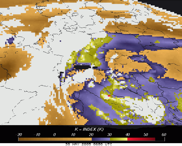
30th May 2005: 0600UTC
The K-index derived using the algorithms of GII developed at EUMETSAT, is presented in a resolution of 5 x 5 pixels in these set of images. In the contrast to the satellite pictures we have seen before the GII should give you a better insight in where potential TS may develop as also ECMWF model data is used as input.
Over Western Europe the frontal system can be seen. The interesting part is just found at the leading edge where Upper Austria, Bavaria and parts of the Czech Republic and Poland show high potential for thunderstorms (pictured in blue). It is also this area in which in a few hours the serious convection will start.
For the Alps, which are pictured in black, no K-index can be computed due to the height (e.g. no existance of dewpoint temperature at 1000 hPa.).
K-index
TS probablity
<20
Thunderstorms unlikely
20 to 25
Isolated thunderstorms
26 to 30
Widely scattered thunderstorms
31 to 35
Numerous thunderstorms
Above 35
Thunderstorms very likely
30th May 2005: 0630UTC
30th May 2005: 0700UTC
Ahead of the front over Upper Austria, Bavaria, the Czech Republic and Poland the situation is still critical with K-index over 30 indicating a high potential for thunderstorms.
30th May 2005: 0730UTC
30th May 2005: 0800UTC
30th May 2005: 0830UTC
On the northside of the Alps an increase in K-index was seen. In two hours this will be the area where the first MCS pops up.
30th May 2005: 0845UTC
30th May 2005: 0930UTC
The first convection is about to start. Over Austria a small cell is pictured in white (GII only works for cloudfree areas!). This cell is flanked by red pixels leading to the assumption that it will further develop and expand.
30th May 2005: 1000UTC
30th May 2005: 1030UTC
The cell previously seen has increased significant. It still is flanked by high K-index values (also compare with 30 minutes before!).
30th May 2005: 1100UTC
Also over the Czech Republic and Poland clouds are recognised. Flanked by high K-index values further development of these convective cells is also expected and witnessed in the future timesteps.