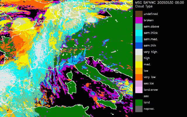
30 May 2005/06.00 UTC - Cloud Type
The main objective of the Cloud Type product is to distinguish between thin and opaque clouds and provide a rough estimate of the cloud top height, and try to distinguish between water particle clouds and ice particle clouds. In addition to this the aim is to be able to delineate stratiform and cumuliform clouds. The highest priority is given to the reliable identification of the major cloud categories: low, medium, high, and semi-transparent cirrus. The product which prototype was developed using the spectral information from AVHRR data is adapted in the NWCSAF using several SEVIRI channels.
Over northern Poland still a convective cell is recognised. The cell itself is characterised as high clouds where the anvil, or cirrus shield, is pictured in blue representing a thin cloudshield. In the following timestep the cell over Poland slowly decays.
Around 11UTC the first cells just north of the Alps emerge. The updraft in these cells may be assumed as severe as these cells are immediately recognised as high reaching. A conclusion we could also assume after studying the severe convection RGB.
The CT classification algorithm is based on the following approach:
- Main cloud types are separable within two sets: the fractional and high semitransparent clouds, from the low/medium/high clouds. These two systems are distinguished using spectral features: IR10.8μm-IR12.0μm, NIR3.9μm-IR10.8μm (in night-time conditions only!), VIS0.6μm (in day-time conditions only!), and textural features (variance IR10.8μm coupled to variance VIS0.6μm in daytime conditions).
- Within the first set, the fractional and high semitransparent are separated using either their IR8.7μm-IR10.8μm brightness temperature differences, but also the VIS0.6μm visible reflectance (in daytime conditions only).
- The remaining categories are distinguished through the comparison of their IR10.8μm to NWP forecast temperatures at several pressure levels, IR10.8μm-WV7.3μm being used to make sure that low clouds are not wrongly classified as medium cloud in case strong low level thermal inversion.
- No separation between cumuliform and stratiform clouds is performed in the current version of CT.
Over northern Poland still a convective cell is recognised. The cell itself is characterised as high clouds where the anvil, or cirrus shield, is pictured in blue representing a thin cloudshield. In the following timestep the cell over Poland slowly decays.
Around 11UTC the first cells just north of the Alps emerge. The updraft in these cells may be assumed as severe as these cells are immediately recognised as high reaching. A conclusion we could also assume after studying the severe convection RGB.