Synoptic Situation
To aid in the analysis of a transitioning system we have broken the life cycle into three sub-sections. Each of these stages are identifable within satellite imagery and the use of particular RGB's in addition to water vapour/ Infrared and visible channels are used.
In the following sections we will review these three phases of Extra Tropical Transition which are:-
Within this section we will examine the factors which lead to the development of Alex, including WV, RGB and Sea surface temperatures.
This section will concentrate on the physical aspects of the transformation of the hurricane, including satellite imagery and satellite derived wind fields (Quickscat).
Many of the characteristics of cyclogenesis are then a familiar feature of mid-latitude development. During this section we will use the satellite imagery, in particular the "Airmass" RGB to distinguish features in the imagery.
Below is an abstract from the NOAA tropical cyclone report which describes the life cycle of Alex from initial developments through to transition.
Storm Track: This section shows the daily position of Hurricane Alex as it formed just off the east coast of the USA. It then engaged with the strong westerly flow aloft and accelerated eastwards across the Atlantic Ocean.
Tropical Cyclone Report
Hurricane Alex
31 July - 6 August 2004
James L. Franklin
National Hurricane Center
26 October 2004
Alex brought category 1 hurricane conditions to the North Carolina Outer Banks as its center passed just offshore, and later strengthened to a category 3 hurricane while near 38°N latitude. Only one other hurricane (Ellen of 1973) reached major hurricane status farther north than Alex.
Three distinct weather systems may have played a role in the genesis of Alex. On 26 July, shower activity increased several hundred miles to the east of the northwestern Bahamas. This activity was associated with a weak surface trough, likely of mid-latitude origin. Disorganized showers persisted just to the east of the Bahamas, in the diffluent region to the east of an upper-level low, for the next couple of days. On 28 July, when a tropical wave reached the area, the extent and organization of the convection began to increase. Analyses show that a broad area of surface low pressure formed early on 30 July just northeast of the central Bahamas. The low moved northwestward and over the next 36 hours the circulation slowly became better defined. By 1800 UTC 31 July, when the low center was located about 175 n mi east of Jacksonville, the system had enough convective organization to be classified as a tropical depression.
The "best track" chart of the tropical cyclone's path is given in Figure 1, with the wind and pressure histories shown in Figure 2 and Figure 3, respectively. The best track positions and intensities are listed in Table 1. As the depression approached a break in the subtropical ridge early on 1 August, its forward motion slowed, and the cyclone remained nearly stationary for the next day or so about 115 n mi east-southeast of Savannah. The depression remained poorly organized initially, due to northeasterly shear and an environment characterized by subsidence and dry air. However, an upper-level trough was approaching from the west, and in advance of this trough the northeasterly flow over the cyclone began to relax. During this transition the depression was able to strengthen, and it became a tropical storm at 1800 UTC 1 August.
Alex began to move northeastward early on 2 August, taking a track that would slowly approach the coastline of the Carolinas over the next 36 hours. The northeasterly shear continued to diminish during the day as upper-level southwesterlies approached. The deep convection, which had previously been confined to the southwest quadrant of the circulation, was now able to organize in bands to the east of the center. Alex strengthened, becoming a hurricane near 0600 UTC 3 August, when it was centered about 65 n mi south-southeast of Cape Fear.
Aided by warm Gulf Stream waters and light shear, Alex continued to strengthen on 3 August as it neared the North Carolina Outer Banks. The hurricane's maximum sustained winds reached 85 KT (category 2 on the Saffir-Simpson Hurricane Scale) at 1200 UTC, and the minimum pressure fell to 972 mb at 1800 UTC. Alex made its closest approach to land near 1700 UTC, with its center located about 9 n mi southeast of Cape Hatteras, while the western eyewall of the hurricane raked the Outer Banks with sustained Category 1 hurricane force winds.
After passing the Outer Banks, Alex turned away from land and accelerated as it became embedded in a deep layer of west-southwesterly flow. Alex strengthened and became a major hurricane (Category 3) at 0000 UTC 5 August, with winds of 105 KT and a minimum pressure of 957 mb. At this time Alex was at 38.5° N (385 n mi south-southwest of Halifax, Nova Scotia), moving east-northeastward at 20-25 KT, and over waters just above 26°C - not factors normally associated with major hurricanes. Only Hurricane Ellen of 1973 attained major hurricane status farther north. While the basic environmental current surrounding Alex was low in shear, the cause of this unexpected strengthening remains unknown.
By late on 5 August Alex had moved north of the Gulf Stream over sub-20°C waters and was weakening rapidly. Moving at 40-45 KT, Alex weakened to a tropical storm after 0600 UTC 6 August and became extratropical a few hours later about 830 NMi east of Cape Race Newfoundland. The circulation of Alex was absorbed into a larger extratropical low by 0000 UTC 7 August.
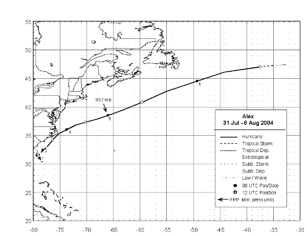
Figure 1: Best track positions for Hurricane Alex, 31 July - 6 August.
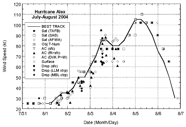
Figure 2: Selected wind observations and best track maximum sustained surface wind speed curve for Hurricane Alex, 31 July - 6 August. Aircraft observations have been adjusted for elevation using 90%, 80%, and 80% reduction factors for observations from 700 mb, 850 mb, and 1500 ft, respectively. Dropwindsonde observations include actual 10 m winds (sfc), as well as surface estimates derived from the mean wind over the lowest 150 m of the wind sounding (LLM), and from the sounding boundary layer mean (MBL). Objective Dvorak estimates represent linear averages over a three-hour period centered on the nominal observation time.
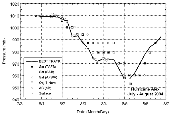
Figure 3: Selected pressure observations and best track minimum central pressure curve for Hurricane Alex, 31 July - 6 August. Objective Dvorak estimates represent linear averages over a three-hour period centered on the nominal observation time.
| Date/Time (UTC) | Position | Pressure (mb) | Wind Speed (kt) | Stage | |
|---|---|---|---|---|---|
| Lat. (°N) | Lon. (°W) |
||||
| 31 / 1800 | 30.3 | 78.3 | 1010 | 25 | tropical depression |
| 01 / 0000 | 31.0 | 78.8 | 1009 | 25 | " |
| 01 / 0600 | 31.5 | 79.0 | 1009 | 25 | " |
| 01 / 1200 | 31.6 | 79.1 | 1009 | 30 | " |
| 01 / 1800 | 31.6 | 79.2 | 1009 | 35 | tropical storm |
| 02 / 0000 | 31.5 | 79.3 | 1007 | 35 | " |
| 02 / 0600 | 31.4 | 79.4 | 1005 | 40 | " |
| 02 / 1200 | 31.3 | 79.0 | 992 | 50 | " |
| 02 / 1800 | 31.8 | 78.7 | 993 | 50 | " |
| 03 / 0000 | 32.4 | 78.2 | 987 | 60 | " |
| 03 / 0600 | 33.0 | 77.4 | 983 | 70 | hurricane |
| 03 / 1200 | 34.2 | 76.4 | 974 | 85 | " |
| 03 / 1800 | 35.3 | 75.2 | 972 | 85 | " |
| 04 / 0000 | 36.0 | 73.7 | 974 | 80 | " |
| 04 / 0600 | 36.8 | 72.1 | 973 | 80 | " |
| 04 / 1200 | 37.3 | 70.2 | 973 | 85 | " |
| 04 / 1800 | 37.8 | 68.3 | 965 | 95 | " |
| 05 / 0000 | 38.5 | 66.0 | 957 | 105 | " |
| 05 / 0600 | 39.5 | 63.1 | 957 | 105 | " |
| 05 / 1200 | 40.8 | 59.6 | 962 | 100 | " |
| 05 / 1800 | 42.7 | 55.0 | 970 | 90 | " |
| 06 / 0000 | 44.5 | 49.3 | 978 | 75 | " |
| 06 / 0600 | 46.1 | 44.2 | 984 | 65 | " |
| 06 / 1200 | 47.0 | 37.5 | 987 | 50 | tropical storm |
| 06 / 1800 | 47.4 | 32.7 | 992 | 30 | extratropical |
| 07 / 0000 | absorbed | ||||
| 05 / 0000 | 38.5 | 66.0 | 957 | 105 | minimum pressure |
NOAA/ National Weather Service